Download

1 / 38
380 likes | 462 Views
WHAT ARE THE TROPICS?. And, how do they work? 2-10-08. TROPICAL HABITATS . Tropical lowland rainforest (=jungle, hylaea) - >100 inches of rain per year Non-seasonal forest Biodiversity is very high Broad-leaved plants Lianas and epiphytes abundant Abundant and constant rainfall

E N D
WHAT ARE THE TROPICS? And, how do they work?2-10-08
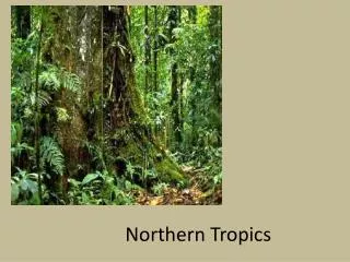
TROPICAL HABITATS • Tropical lowland rainforest (=jungle, hylaea) - >100 inches of rain per year • Non-seasonal forest • Biodiversity is very high • Broad-leaved plants • Lianas and epiphytes abundant • Abundant and constant rainfall • Components: • Floodplain – where rivers swell then drop (2% of the Amazon Basin) • Varzeas – seasonally flooded with white water (2% of the Amazon Basin) • Terre firme – high ground that does not flood (this is ca. 96% of the Amazon Basin) • Tropical higher-ground rainforest (Chocó of Colombia, 360 inches of rain per year) • Tropical moist forests • Deciduous forests • Dry forests • Cloud forests – relatively high, cloud enshrouded (thus moist) forests • Páramos – high, cold moist plateau
As one moves north or south from the tropics, there is a latitudinal change in biomes: tropical rainforest, temperate forests, taiga, tundra, polar ice. As one moves up mountains, one may see the same progression (depending on the height and location of the mountain). Rule-of-thumb: for every 1000m one ascends in elevation, average temperature drops 6ºC.
Humbolt’s Law Each 300 ft ascent up a mountain in the tropics has the same average temperature change as if moving 67 miles toward the pole.
TYPES OF RIVERS • White water rivers – sediment (from the Andes) rich rivers that are turbid (usually reddish) • Black water rivers – drain ancient soils with little mineral content; clear, but usually dark due to organic materials • Igapó – forests that line these rivers • Clear water rivers – low levels of sediment and/or decomposing vegetation
WHAT DETERMINES SEASONS IN THE TEMPERATE ZONES? The arrival of cold weather.
WHAT DETERMINES SEASONS IN THE TROPICS? Rainfall: wet season vs. dry season.
WHAT ARE BELIZE’S RAINY SEASONS? • Belize has two – sort of. • The real rainy season begins end of May/beginning of June, and peaks Sept-Nov. It is characterized as short rains that fall “in buckets.” • It can start in Toledo in May/June (average rainfall is 190 inches) • But in Corozal to the north it may start in July/August (average rainfall is 30 inches) • The other rainy season is caused by “northers” – the remnants of U.S. winter storms that drift south. • Usually last a couple of days as off and on long drizzly rains. • May start in November and end in April, but the norm is January & February and affect the whole country the same.
WHY DOES IT RAIN IN THE TROPICS? • Humid forests, hot weather – so, lots of humidity in the air. • The warm, humid air rises (convection) and forms clouds. • The higher the air goes, the cooler it gets. Cool air can’t hold as much moisture as warm air. • The clouds get higher, darker, then they drop their water as rain. • The next day, the cycle repeats itself.
WHY ELSE DOES IT RAIN IN THE TROPICS? • The waters of the tropics are warm. • Prevailing winds are consistently from the same direction. • They pick up moisture as they sweep across the water. • Either the moisture laden winds get caught up in the convection when they hit land and ultimately drop their water, or • They hit mountains, are forced up to cooler levels, then drop their water.
Huge amounts of rain are not required if there is constant/frequent cloud cover that supplies humidity to the plants.Ex: cloud forests
TRANSPIRATION • Plants suck water from the soil • When there is too much water in their circulatory system, it evaporates via mesophyll tissue on the underside of the leaves • As the water evaporates, its loss pulls water up the plant from the soil.
CLIMATE: 64.4ºF IS THE KEY • Tropical: January average of >64.4°F. • Subtropical: January average fall between 32°F and 64.4°F. • Temperate: January average at least sometimes falls below 32°F.
LOCATION: The tropics are located between the Tropics of Cancer (23.5°N) and Capricorn (23.5°S).
The Permian World – 225 million years before present (mybp). We call the single continent Pangea. From Strahler. Physical Geography. 4th Ed.
The Late Triassic world – 180 mybp. Note the northern continent – Laurasia, and the southern continent – Gondwana (or Gondawanaland). From Strahler. Physical Geography. 4th Ed.
The Late Jurassic world – 135 mybp. Gondwana has broken up into proto-India and a single land mass that will break into proto-Antarctica and proto-Australia. South America and Africa are beginning to separate. From Strahler. Physical Geography. 4th Ed.
The Late Cretaceous world – 65 mybp. Note proto-India headed toward Asia. When it collides, it will create the Himalayan Mountains. From Strahler. Physical Geography. 4th Ed.
The world as we know it today, showing the location of tectonic plates. From Strahler. Physical Geography. 4th Ed.
What happens along the edges of the tectonic plates? Why, subduction, of course. From Strahler. Physical Geography. 4th Ed.
The molten upper mantle oozes out along an undersea rift and the continental crust spreads outward. From E.M.E. Plate Techtonics Slide Series. 1978.
New ocean floor is made as the rift widens and the crust moves away. From E.M.E. Plate Techtonics Slide Series. 1978.
You can see here the various plates that make up our world and the relative positions of our existing continents.
The plates still move, so if you live for 70 or so million years, you may see France coalesced with the U.S.
This figure may be a little clearer. From E.M.E. Plate Techtonics Slide Series. 1978.
The bottom-line is that continents are constantly being made, recycled via subduction, and certainly always on the move. Understanding these movements helps one understand the present-day distribution of flora & fauna.
An application of our knowledge of continental drift: The distribution of mangroves about 66 million ybp & today.
ECOTONEA place where two habitats merge (ex.: the zone along the margins of a forest and open field).
EDGE EFFECTIn an ecotone, there is often more species diversity along the “edges” of the two habitats than there is in either habitat. This is because the edge shares aspects of each habitat and thus offers habitat to a greater variety of critters.
FORESTS ALONG THE EDGES OF RIVERS • Gallery forests – forests that line waterways • Riparian forests – “riparian” means along the edges of waterways, so this is a synonym of gallery forests • Igapó – this type of forest along black water rivers