Download

1 / 62
710 likes | 1.05k Views
Airport Surveying-GIS Program. David Perry Contractor for FAA, Airport Engineering Division (AAS-100). Overview. History of the Program Benefits of the program to the FAA and our airport sponsors Why implement such a process? Questions. History of the Program.

E N D
Airport Surveying-GIS Program David Perry Contractor for FAA, Airport Engineering Division (AAS-100)
Overview • History of the Program • Benefits of the program to the FAA and our airport sponsors • Why implement such a process? • Questions
History of the Program • Conceived to address the airport data problems the FAA was experiencing agency wide • It was recognized that there had to be a better way of collecting, storing managing, and sharing the data about our airports • Adopted as a FAA Flight Plan goal in 2006
What Is The Length Of This Runway? The answer depends on who you ask !!!!
Which Data Is Correct? NFDC NASR Data NFPG Data iOEAAA
How The Program Is Designed To Help The Airport Surveying-GIS program provides a single portal for the collection and dissemination of standards based verified source data to support future design, mapping, surveying, and construction activities from a known good (independent verification and validation) and maintained data set. Airports-GIS provides the foundation for connecting the airports, FAA, and other agencies A central database for storing survey, charting, analysis, and planning data
Airport Surveying/GIS Program Vision “All I need to know about airport data … I learned in kindergarten.” In other words … data sharing Provide an interoperable web-based system for the collection, management, maintenance and sharing of airport data addressing the needs of the FAA lines of business and the individual airports collectively rather than individually.
Greater Productivity Submission and processing of electronic Airport Layout Plans Data is collected once and then managed through the system ensuring the most current data is readily available Dependable Electronic management and processing of all airport data … one stop shop for managing and updating an airports data Connected GIS is a scalable and interoperable technology allowing others to use and share data without recollecting, because the metadata provides the source, accuracy, collection methodology, etc. of the dataset. Each entity builds on the base data set to meet its own requirements Best Economics Program Benefits
Airport Sponsor Benefits • Provides a single point of entry for the submission and maintenance of AIRPORT DATA and to communicate the changes electronically to the FAA • Provides non-GIS Equipped Airports with a GIS Foundation for: • Airport Layout Plans, • Obstruction Charts, • Construction plans, and other airport mapping products • Planning • Zoning • Improves Response to Airport Changes • Provides On-line Access to Electronic Obstruction Charts and Airport Layout Plan Data to FAA, Airports, and Consultants • Provides the sponsor access to FAA data • Speeds Production and Currency of FAA Charts and publications
Why Implement Such A Process? • To meet the challenges of the changing role of aeronautical data in the system, the FAA needed to rethink the way it collects, stores, and maintains the data about airports. • We need to focus on managing our airport and aeronautical data.
Why Implement Such A Process? • The role and importance of airport and aeronautical data in meeting the safety, regularity and efficiency of air navigation changed significantly with the implementation of area navigation (RNAV), required navigation performance (RNP) and airborne computer based navigation systems.
Answer … • To provide a common platform for the collection, maintenance, and dissemination of airport and aeronautical information and sharing of the data for improved efficiency of airport operations for both the sponsor and the FAA.
The rest of the story … • Current initiatives within aviation industry and the FAA require a data centric airport environment, as opposed to the traditional product based environment. • Airports GIS • D-NOTAMS • D-TAXI
Why Change? • UDDF (Universal Data Delivery Format) delivered data … it was an outline, it did not tell the whole story! • This runway entry only shows the geographic position (latitude/longitude, true bearing, touchdown zone elevation, and four (4) elevation points on an 11,500 foot runway.
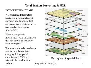
The answer … a richer data set • Geospatial data identifies the geographic location and characteristics of natural or man-made features • Moving to a geospatial environment allows us to not only know the geographic location but also, and sometimes more importantly the characteristics of a feature. • In the example (left) of a runway … • We not only have the coordinates (1) • We also have the characteristics (2) • Width • Length • Surface Type • Surface Material • Surface Condition • A much richer data set …all together in a single place! 1 2
Airport Surveying-GIS Program Timothy Roe, Program Manager, Airport and Airspace Programs FAA, Air Traffic Organization, System Operations, AIM and Airspace Aeronautical Information Management (AJR-32) Architecture and Planning Team
FAA Advisory Circulars • AC 150/5300-16 • Establishes the requirements for and how to install geodetic control • AC 150/5300-17 • Identifies the requirements for and how to collect the required imagery • AC 150/5300-18 • Identifies what to collect, required accuracy and how to provide the data
What is Geodetic Control? • A network of carefully measured points used as a reference for other surveys or to establish or measure accuracy in map making whose precise positions and/or heights are known and take into account the shape and size of the Earth.
At airports we call them PACS/SACS • PACS = Primary Airport Control Station • SACS = Secondary Airport Control Station • A stainless steel rod three-dimensional (3-D) drivable survey monument is the recommended survey marker producing the stability required for most conditions.
ARP Policy on Permanent Geodetic Control (PACS/SACS) AC 150/5300-16, paragraph 2.2 Airports Requiring Geodetic Control Monumentation • Permanent Control. FAA Regional Airports Divisions will determine which airports require permanent geodetic control monumentation in the form of PACS or SACS based on the activity (operational or proposed future construction) at the airport. However, for all airports in the National Plan of Integrated Airport Systems (NPIAS), we strongly recommend that at least the PACS be established.
PACS and SACS considerations for Airports • Permanency with appropriate geographic location and spacing. • Ease of recovery, location should allow efficient use by surveying community. • Accessible by public. Public property should be utilized where feasible. • Minimal multi-path. • No known potential conflict with future development. • Aerial-photo identifiable. • Protect the monuments … they are important and expensive!
Geodetic Control Required Deliverables • Use the FAA Deliverable Checklist to guide the production and delivery or project deliverables. • Survey Work Plan (Prior to starting … more later) • Quality Control Plan (Prior to starting … more later) • Project Status Reports (more later) • Final Project Report
Final Project Report • Used by NGS to verify the information provided by the surveyor • Contains such things as … • Description of the Project • Copies of Field Logs • Original Data • Descriptions of PACS and SACS location • Photographs of PACS and SACS • All required elements are listed in the FAA deliverables checklist! • Submitted through Airports GIS web site
FAA Advisory Circulars • AC 150/5300-16 • Establishes the requirements for and how to install geodetic control • AC 150/5300-17 • Identifies the requirements for collecting the required imagery • AC 150/5300-18 • Identifies what to collect, required accuracy and how to provide the data
Why Do We Require Imagery? • The role and importance of airport and aeronautical data in meeting the safety, regularity and efficiency of air navigation changed significantly with the implementation of area navigation (RNAV), required navigation performance (RNP) and airborne computer based navigation systems. • There are 2 reasons we require imagery. • The primary reason we require imagery for projects involving safety critical data is to ensure the quality of the aeronautical information collected. • Secondly, we feel that the use of imagery is an accurate and potentially cost saving method of collecting this type of data. • Current initiatives within aviation industry (moving maps, electronic flight information, advanced avionics) require a data centric airport environment, as opposed to the traditional product based environment.
“leaving footsteps …” Others should (read as must) be able to retrace the original surveying or mapping product (without having to contact the person who created it!)
Required Deliverables (for NGS) • The airport sponsor must provide NGS with digital stereo imagery of the area of analysis. The dimensions of this area depend on the type of survey the contractor is requested to perform. • Acquire the imagery within at most 6 months prior to the ground survey (AC 150/5300-18 survey). • Submit the imagery well in advance of the survey deliverables for NGS review and approval. • Upon imagery approval, the final survey deliverables may be submitted. • Submit the imagery and associated deliverables directly to NGS for review.
Required Deliverables (for FAA) • Provide the FAA with digital orthoimagery of the area(s) flown. • Develop the orthoimagery using the specifications defined by the Federal Geographic Data Committee in FGDC-STD-008-1999, except the imagery should not be resampled, they should be developed at the resolution of the original imagery used for analysis. • Provide metadata for the orthoimagery as described in the FGDC standard. Submit the digital orthoimagery to the FAA on similar media as hat uses to provide the imagery to NGS. Include on the delivery media FGDC compliant metadata for the orthoimagery.
FAA Advisory Circulars • AC 150/5300-16 • Establishes the requirements for and how to install geodetic control • AC 150/5300-17 • Identifies the requirements for collecting the required imagery • AC 150/5300-18 • Identifies what to collect, required accuracy and how to provide the data
Organization of AC 150/5300-18B • Though it looks daunting from the outside … it’s not really that bad! • The AC has five (5) chapters and appendices • Chapter 1 discusses general survey guidance and specifications • Chapter 2 discusses specific survey specifications and standards • Chapter 3 discusses geospatial standard and specifications (GIS rules) • Chapter 4 discusses data translation and existing data • Chapter 5 discusses specific about the airport features • Chapter 1 – 4 cover about 100 pages the rest is chapter 5!
Types of Surveys • Surveys are on completed on airports for many different reasons • Boundary • Construction • Utilities • Obstruction • Each served a single purpose, each was not coordinated sometimes collecting similar or the exact same data • Some even happening at the same time!
New Philosophy on Airport Surveys • AC 150/5300-18 is designed to collect data about the airport as a whole rather than as a group of individual projects. • Since most everything on an airport is interconnected or has a relationship to other things and these relationships should be preserved. • Data collection projects should build on one another. • Data provided as part of a design should be incorporated into the airport data set and later verified rather than collected new.
Obstruction Surveys Alphabet Soup Eye Chart or Survey Requirements ??? • ANA-LPV • ANAPC • PIR • CGR • BV • NP-D • AV • C • D
Airport Airspace Analysis • Under the previous standard (FAA 405) there were as many different types of surveys • These multiple types did not always provide the information required and most were incorrectly based on 14 CFR 77 • AC 150/5300-18B has only two types of “obstruction surveys” … it is a single multifaceted surface not individual pieces • Vertically Guided • Non-Vertically Guided
Vertically Guided Airport Airspace Analysis Surface • These specifications support the airport’s planning and design activities for the development of vertically guided instrument approaches such as ILS, PAR, MLS, LPV, TLS, RNP and Baro/VNAV
Non-Vertically Guided Airport Airspace Analysis Surface • Use the following specifications and associated figures to complete object identification on and surrounding airports to runways designed for visual or non-vertically guided (NVG) operations (Lateral Navigation (LNAV), Localizer Performance (LP), VOR, NDB, Localizer, Localizer Directional Aid (LDA), etc.)
Other Types of Surveys • AC 150/5300-18B for the first time discusses standards for other types of surveys relating to or happening on Airports, most of which you are familiar with • Boundary/Land Use • Sub Surface Utility Engineering • Topographic • Airport Mapping Database • Construction • Airport Pavement
Acceptable Datum's • With regard to spatial data, a datum is a reference to an approximation of the earth’s surface or a Datum. Use the following Datum's for spatial data submitted in compliance with this standard: • All horizontal data must be submitted referenced to the North American Datum of 1983 • All vertical data must be referenced to the North American Vertical Datum of 1988 (NAVD88).
Data Translation and the Use of Existing Data • Many airports have developed and collected data over the years through different projects or planning efforts. This data exists in many forms from drawings in a CADD system, to individual records in databases or through a hardcopy management system. • Since the 1980’s the form of the data has evolved from a totally paper-based product to where many airports have some if not all the data available electronically. As the tools and technology changed from linen to Mylar and finally to digital CADD and GIS formats, only a few airports made the effort to ensure the quality of the data set. • In some cases, the user performed data transformations from one datum to another without regard to the actual accuracy of the data. With the availability of more digital data and its associated detail, the expectations of those charged with maintaining this information also increased.
Data Translation and Use of Existing Data • However, no real effort or process related the data values to the true value and associated data accuracy by tracing the data back to its source. When considering the reuse of this data in a current or future project, the quality of the data is the first and most important factor determining its usability. • ICAO) defines data quality as, “A degree or level of confidence that the data provided meets the requirements of the data user in terms of accuracy, resolution and integrity”. One of the first steps in determining the quality of a data set is determining its origin • What is the data source, and is it traceable to the time and point of collection? If the data is not traceable to the source, then the data provider should implement a defined and repeatable process to determine the spatial accuracy and reliability of the data before the data is used.
Maintenance of Data • Purpose is to ensure the data quality remains at an acceptable level. • Make updates to airport object and obstacle data as soon as practical with sufficient lead-time to ensure the information is available when required to meet the AIRAC cycle amendment schedule. • Terrain and obstacle require updating to account for uncovered errors as well as to change appropriate data (e.g. due to construction activities or vegetation growth).
GIS Data Features • The bulk of AC 150/5300-18B details the airport feature descriptions defining the specifications for each feature group and class. • Utilize the specifications defined to ensure the data delivered is accurate and meets standards. • Each feature is described by … • Feature group • Geometry type, • Sensitivity, requirements, • Positional accuracy • Data capture rule, • Attributes required to provide the data to the FAA.
Airport Features • There are eleven feature groups in the standard • Airfield Navigational Aids • Airspace Sea Plane • Cadastral Security • Environmental Surface Transportation • Geospatial Utilities • Manmade Structures • In each Feature Group are the individual features.
What Attributes are required and Which are Optional? • Airport Surveying-GIS program looks at the airport as a whole rather a group of disconnected individual parts…so it should be attributed as a whole. The SOW determines who does what .
What Attributes Are Required and Which Are Optional? • All attributes and features located on the airport are required … • Some are required from the surveyor • Others are required of the sponsor or their consultant • The SOW determines who does what
Data Sharing Data Sharing e- NASR Integrating Airports GIS into Our Business Processes Airport Sponsor Data collection, planning, design, development, or analysis activities FAA Data Region/ADO review, analysis or processing Airports GIS Database Safety Critical Non-Safety Critical Data NGS Airports GIS is being designed to provide the data and tools airports and the FAA need to accomplish their work collaboratively in an all digital format.
What is the purpose of a SOW? • “A narrative description of products, services, or results to be supplied.” • The SOW should indicate … • A business need • Document the product or service requirements that they project is undertaken to create • All projects should support the organization’s strategic goal • Get a new approach procedure • Improve access to larger aircraft • Plan for future improvements • Citation: A Guide to the Project Management Body of Knowledge, Third Edition, 2004
What Elements Should A Good SOW Contain? • A good SOW should detail … • What is needed … why are we doing the project • What standards should be applied • What deliverables are required • What audits can or will be conducted • When the deliverables are required. • What scope verification will be used