Download
1 / 8
80 likes | 203 Views
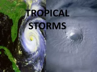
Naval Oceanography: Enabling Decisions through Excellence in Tropical Cyclone Forecasting. CAPT Michael Angove Commanding Officer, NMFC/JTWC Presented to Interdepartmental Hurricane Conference Miami, FL 28 Feb 2011. Western Pacific: Active Battlespace.

E N D
Naval Oceanography: Enabling Decisions through Excellence in Tropical Cyclone Forecasting CAPT Michael Angove Commanding Officer, NMFC/JTWC Presented to Interdepartmental Hurricane Conference Miami, FL 28 Feb 2011
Western Pacific: Active Battlespace 1.4M sq miles of area lost to error swath at 72 hours. A 50% reduction in error would add up to 21M sq miles of sea maneuver per year. Current uncertainty Proposed uncertainty PACOM Goal: Increase US/Coalition Sea Maneuver Space
EXPERIMENTAL TC-COR SETTINGS SITE TC-COR Agrihan 2 Alamagan 2 Anatahan 2 Pagan 2 Saipan 3 Tinian 4 Battlespace on Demand:“Reclaiming Enemy Territory” • Tier 3 – Decision Layer • Strike Probability • Condition of Readiness • Sortie Options • Tier 2 – Performance • TC Warnings • Surge/inundation ~ $1-2M/yr • Tier 1 – Modeling • NUOPC/HFIP • COAMPS - TC • ESPC • Tier 0 – Environment • Remote Sensing • In situ Obs ~ $9M/yr
Environment TierRemote Sensing and Observations • The Navy is heavily dependent/leveraged upon partnerships for satellite based observational data. • Advocate access to/expanded use of existing data streams v. building new sensors. • Support NOAA/NESDIS access to OSCAT • Navy programmed investments targeted at oceanographic applications (e.g., GFO 2, UUVs) • Key Capability Gaps • OSVW • Scatterometer/WindSAT • Vector capable MIS/DWSS • Imagers • WindSAT • AMSR-E • TRMM
Modeling TierTrack and Intensity forecasts Track continues to be a top priority. The Navy views improvements to global modeling capability as best means to improve track forecasts. Navy/NOAA/USAF Partnership is key enabler NUOPC HFIP (NHC / JTWC) Earth System Prediction Capability (long term) Structure and Intensity: Storm Scale modeling initiatives HWRF/HFIP COAMPS-TC • Improvements in structure and intensity forecasts dependent on first improving track forecasts 5
Performance and Decision Tiers TC warnings Planned ATCF Improvements Wave Heights Matching TC tracks to WW3 Surge and inundation Naval Oceanographic Office RTP FY01 Improvement to TC Model Forecasts FY02 Modeling TC Structure and Track FY06 4DVAR for Global Atmospheric Weather Prediction FY09 Prediction of TC Track and intensity Using COAMPS-TC FY11+ enhanced JHT participation Probability Based Decision Tools TCCOR/Sortie • Quantifying Uncertainty Reduces Uncertainty 7
WSP and Hurricane Earl Sortie This depiction is for OFFICIAL USE ONLY! Not for public release (Norfolk, VA KNGU) Greatest chance for 34 kt wind: (72hr Incremental period) 12z Thu to 12z Fri (Norfolk, VA KNGU) Greatest chance for 50 kt wind: (72 hr Incremental period) 12z Thu to 12z Fri 72 hr Cumulative Probability for 50 kt winds 5-9% 10-19% 20-29% 72 hr Cumulative Probability 50 kt winds24 hrs ago Norfolk, VA 7% 6% 34 kt winds24 hrs ago Norfolk, VA 28% 19% *Experimental Threshold Probability: Norfolk, VA (KNGU) 50 kt Forecast = NO 34 kt Forecast = YES Based on 15Z 31 Aug statistical and dynamical model data and Monte Carlo Wind Speed Probabilities
SummaryPartnerships = Success • Navy supportive of and dependent on “Federal Solution” (to include DWSS) for remote sensing needs—OSVW key capability gap. High-resolution imagers nearing end of life. • Accurate track forecasts key to enabling naval operations—global modeling improvements best investment • Significant IA investment : NUOPC and next-generation modeling in cooperation with NOAA and USAF • Research on intensity and structure needed • Support OFCM WG/TCR • Storm-scale modeling initiatives • Operational Center (JTWC/NHC/CPHC) Collaboration • Expanded JHT partnering/leveraging