Download
1 / 40
780 likes | 1.94k Views
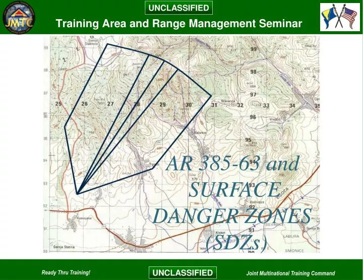
AR 385-63 and. SURFACE. DANGER ZONES. (SDZs). Agenda. AR 385-63 overview, Chapter 1 Ranges and Range Safety. SDZ Breakdown. AR 385-63. Safety – Policies and Procedures for Firing Ammunition for Training, Target Practice, and Combat, 15 November 1983.

E N D
AR 385-63 and SURFACE DANGER ZONES (SDZs)
Agenda AR 385-63 overview, Chapter 1 Ranges and Range Safety SDZ Breakdown
AR 385-63 Safety – Policies and Procedures for Firing Ammunition for Training, Target Practice, and Combat, 15 November 1983 Clarifies requirements on ranges for: Officers in Charge Range Safety Officers Revised ballistic data for Surface Danger Zones Incorporates new standardized range designs Clarifies combined arms live fire exercises
AR 385-63 Purpose “To prescribe general safety precautions necessary to minimize the possibility of accidents in the firing and other uses of ammunition and explosives by troops in training, target practice, and as much as possible, combat and range operations…”
Surface Danger Zones Instructions and dimensions for SDZ's will be developed and specific danger areas will be indicated. The depicted surface danger zones are the minimum requirements. The SDZ dimensions listed are only adequate when employed with properly functioning safety equipment and devices, and when trained and competent personnel follow firing procedures.
What if the SDZ doesn’t fit? General firing requirements will be followed. Under certain conditions, specific types of firings may be conducted at locations having less land or air area than required. Units will be directed to employ additional controls and will be limited in the type of firings. Waivers must be requested.
Waivers A departure from regulatory requirements in accordance with AR 385-63.
Waiver Authority The following persons may waive safety criteria of AR 385-63 if it is acceptably safe and is in the best interest of the United States: MACOM Commander Superintendent, USMA Chief, National Guard Bureau Commanding General, Fleet Marine Force, Atlantic and Pacific
Waive Only What You Own The Waiver Authority can only waive what he or she owns: Airspace requirements may be waived by the Federal Aviation Administration (FAA) or comparable host nation agency Water traffic requirements, as they apply to firing over navigable waters are waived by the U.S. Army Corps of Engineers or comparable host nation agency If in a host nation, the more stringent regulations must be followed
Delegated Waiver Authority Can reduce the dimensions of surface danger areas when the terrain, artificial barriers, or other controlling factors make smaller areas safe Can modify prescribed firing procedures appropriate to the training of participating troops to increase realism inn training.
SDZ Waiver Bottom Line Projectiles or debris caused by firing ammunition or explosives must be contained within the boundaries of the surface danger zone. Only personnel thoroughly trained and qualified in firing ammunition…will take part in combat firing and combined arms exercises.
Assistance with Waiver Minimum Requirements A statement citing the paragraph of the regulation to be waived. Description of conditions, scaled maps showing distances to internal and external exposures, topographical maps of the area, personnel involved, and facilities exposed. The type of ammunition and weapons as identified in proper technical manuals. Map coordinates of the firing position and quadrant elevation of fire. The firing position and direction of fire will be plotted on the scaled map and a scaled surface danger zone will be shown in meters.
Assistance with Waiver Minimum Requirements An SOP for firing and range control. Other precautions that will be taken to achieve safety in operations to fully compensate for the lack of compliance with this regulation. Profiles through the gun-target-line showing the relative elevation of the piece to be fired, the target, and earthen backstop, if any. Also, furnish profiles from the firing position through the right and left limits of fire. A MACOM position statement recommending approval or disapproval or modification of the basic request for training.
Range Safety Installation commanders will establish a range safety program. Appoint qualified range control personnel to monitor and enforce range safety and operational requirements. Installations will publish local SOPs for the safe operation and use of ranges and training facilities. Coordinate and schedule all firing. Notify installation personnel and the public of firing and exercises involving possible hazards to the public.
Range Safety Continued Establish procedures for controlling and coordinating use of airspace. Survey and post range boundaries and off- limit areas to prevent trespass and entry by unauthorized personnel into surface danger zones and impact areas. Post range guards, barriers, limit of fire markers, and signals. Investigate incidents or accidents involving weapons or ammunition with firingg units.
Range Records Maintain detailed records that – Describe the range area, including detailed permanent charts and overlays. Provide information on the types and amounts of ammunition fired into the range areas. Record known or estimated number of duds located in range impact areas.
Airspace Safety Requirements Airspace control measures and coordination required for any range where the maximum ordinate of any ammunition will exceed 45 meters above ground level. Establish a vertical danger zone for firing operations when maximum ordinate exceeds 45 meters above ground level.
Notice of Firing Before firing involving possible hazard to the public, the commander will issue a warning order through the public news media. Date and time of firing, and describe the boundaries of the range area. Commander will enforce all closed danger areas involving possible hazard to the public. A warning order will be published and issued to the entire population of the installation at least 24 hours in advance.
Trespassing on Range Areas Precautions will be taken to prevent – All unauthorized persons from entering the surface danger zone before firing. Trespassing on target ranges during firing. Handling or removal of unexploded ammunition (dud) by unauthorized personnel. Livestock may be excluded unless agreements have been made in writing with the owner or owners.
Warning Signals and Signs Persons approaching a firing area in use will be warned. Scarlet danger flags and, when necessary, warning signs will be displayed at appropriate points. Scarlet streamer will be used during daylight hours, and a blinking red light during night hours will be displayed from a prominent point for a range complex at all times during firing. No firing will take place unless these conditions are met.
Warning Signals and Signs Continued Limit of fire markers both external (outer) and internal (inner) will be emplaced to denote right and left limits of fire.
Warning Signals and Signs Continued The boundaries of all range areas adjacent to roadways and points of entry, or along the outside limits of ricochet areas will be posted with permanent signs. The signs will be placed at 200 meter intervals or less, or in a way that will insure that a person cannot enter the range without seeing at least one sign within a legible distance. Hilly or wooded terrain may require more signs than would flat, open terrain. The design, color, and size will conform to guidance in AR 385-30.
Education Commanders will place special emphasis on aggressive educational programs. Local news media will be used periodically to warn the nearby communities of the hazards in trespassing on range areas and in handling unexploded ammunition.
Ammunition and Weapons Current Field and Technical Manuals for the ammunition and weapons to be fired must be on the range during firing. No new production discarding sabot rounds will be fired over the head of unprotected troops. When any round or item of ammunition or explosives (or their components) has malfunctioned, further use of rounds or items will be locally suspended.
Small Arms and Machine Guns Surface Danger Zone building basics Batwing or New Methodology Single firing point to a single stationary target Step by Step batwing building
SDZ Angles, Areas, Distances and Lines Drawing Data Distance X Distance Y Distance W Area A Area B Cap Firing point Target Gun Target Line (GTL) Dispersion area Angle P Angle Q Ricochet area
Drawing Data Drawing by: Scale: Drawing by: Scale: Weapon: Ammunition caliber: Ammunition type: Distance X: Date drawn: Verified by: Weapon: Ammunition caliber: Ammunition type: Distance X: Date drawn: Verified by: Other data may be added as necessary to clarify the drawing
Firing Position Distance X Firing Position – the firing position is where a weapon system will engage a target from. Initially, we will start with only one firing position and build from there in later slides throughout the class. Gun Target Line (GTL) Target Firing Point
Target Location Distance X Target Location – the point or location within the surface danger zone where a target is emplaced for weapon system engagement. The target is identified along the gun target line at the scaled range to target. Gun Target Line (GTL) Target Firing Point
Gun Target Line (GTL) Distance X Gun Target Line (GTL) – is drawn from the firing position through the target area. Its length is equal to Distance X (next slide). Gun Target Line (GTL) Target Firing Point
Distance X Distance X Distance X – The maximum distance a projectile will travel when fired or launched at a given quadrant elevation with a given charge or propulsion system. Typically, plan 10o for super elevation Gun Target Line (GTL) Target Firing Point
Cap Cap Distance X Cap – the cap is drawn with a compass where the point of the compass is placed on the firing position and the radius is set to Distance X. It is drawn across the top or end of the Gun Target Line, and creates the downrange end of the Gun Target Line (GTL) Target dispersion area. Firing Point
Dispersion Area Distance X Dispersion Area – the area within the surface danger zone located between the gun target line and the ricochet area. This area accounts for human error, gun/cannon tube wear, propellant temperature, etc. Unless otherwise directed, Dispersion Area Gun Target Line (GTL) Target dispersion area will be 5o on either side of the Gun Target Line (GTL) Firing Point
Distance Y Distance X Distance Y – the maximum distance downrange at which a Distance Y Target Firing Point lateral ricochet is expected to occur when a projectile is fired at a given quadrant elevation. Gun Target Line (GTL)
Angle P Distance X Angle P – is the beginning angle for the ricochet area measured from the firing point downrange along the edge of the dispersion area. It is only used on Gun Target Line (GTL) the Batwing Surface Danger Zone. Target Angle P Firing Point Angle P
Angle Q Distance X Angle Q – this is the angle measurement downrange, beginning at Angle Q Angle Q the end of Distance Y along the edge of the dispersion area. It is measured along Gun Target Line (GTL) distance Y outward from the dispersion area on Batwing Surface Danger Target Zones. Firing Point
Distance W Distance X Distance W – is the distance between the outside edge or border of the ricochet area and the outside edge or border of the dispersion area on Batwing Surface Danger Zones. It is drawn parallel to the outside edge of the dispersion area between where the Distance W line crosses Angle P and Distance W Distance W Distance W Distance W Angle Q. All excess lines are erased. Firing Point
Ricochet Area Distance X Ricochet Area – the area located to the left and right of the dispersion area which contains projectiles after making initial contact with the target medium. For surface danger zones having angles P and Q, it is Ricochet Area Ricochet Area Gun Target Line (GTL) also the area located to the left and right of the dispersion area. The ricochet area is defined by Target Distance W. Firing Point