Download
1 / 40
400 likes | 407 Views
www.geotech.com. Gathering, Managing, and Displaying Soil Data Using Automated Tools. Dr. David W. Rich drdave@geotech.com. Atlanta, GA April 28, 2013. High Level View of the Process. Plan your sample events. Store in a robust repository. Analyze and display data.

E N D
www.geotech.com Gathering, Managing, and Displaying Soil Data Using Automated Tools Dr. David W. Rich drdave@geotech.com Atlanta, GA April 28, 2013
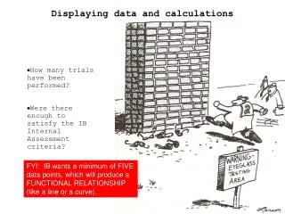
High Level View of the Process Plan your sample events Store in a robust repository Analyze and display data Manage field and lab activities Manage data and quality It’s all in one location www.geotech.com
Environmental Data and the “Cloud” www.geotech.com
Environmental Data and the “Cloud” www.geotech.com
Introduction www.geotech.com
Planning Your Sample Events Entering stations www.geotech.com
Container Labels www.geotech.com
Planning the sample event www.geotech.com
Gathering Field Results www.geotech.com
Cloud-based log data entry Gathering Boring Log Data Images courtesy of LogItEasy.com www.geotech.com
Gathering Continuous Data Gathering continuous downhole data Images courtesy of www.geotech.com
Gathering Soil Samples www.geotech.com
Specifying Import Options Import Wizard www.geotech.com
Quality Control - Consistency Checking www.geotech.com
Quality Control - Validation www.geotech.com
Quality Control - Validation Summary www.geotech.com
Bulk Data www.geotech.com
Storage and Retrieval - Selection and display www.geotech.com
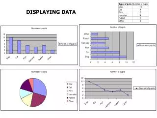
Display Options Determine How Your Results Are Displayed Example options: • Regulatory limits • Values and flags • Unit conversion • Date display • Calculated parameters • Non-detects • Significant figures • Graph display options • Custom queries www.geotech.com
Database OutputExamples - Graphs www.geotech.com
Report Examples Reports ** edited www.geotech.com
Database OutputExamples - Graphs www.geotech.com
Generating Output www.geotech.com
Excel Export www.geotech.com
Display Using GIS • You need a base map or image • Sample locations must have coordinates • And both have to match • GIS software like ArcGIS makes the maps • Specialized software can make environmental-specific displays • Integration between the EDMS and the GIS can save time and improve quality www.geotech.com
Add to the GIS as XY data Define display parameters Display Using ArcGIS www.geotech.com
See Results on the Screen Note non-detect exceedence www.geotech.com
Crosstab Callouts From the Database www.geotech.com
Soil Borings with Values from the Database Benzene (mg/kg) Lithology Benzene (ppm) www.geotech.com
Time Sequence Graphs on the Map www.geotech.com
Radar Plots and Contours on the Map www.geotech.com
Managing and DisplayingSite Geology • You might want to assign geology and lithology to each physical sample • This makes it easy to tie the geology to field and lab data • Or store formation “tops” by location independent of the samples • This probably better represents the actual site geology www.geotech.com
Voxler Example www.geotech.com
Benefits of better data management Decrease overhead - One industrial company was able to save $12,000 per year on just one project by moving the data management tasks to a much less expensive clerical person. Lower operating cost - Another used data management to get their regulator to approve less-frequent sampling intervals for about two of their wells per year, resulting in a savings of $9,000 each year, cumulative from year to year. Increase efficiency – For one organization, the time to process an electronic deliverable decreased from an average of 30 minutes to 5 minutes, resulting in an annual savings of $5,000 per year on each project. An Indian tribe needed to make nine graphs/year for their EPA PM. With Excel, it took 3 months. With a database with integrated graphing, it took 10 minutes. Increase revenue - A consulting company client was able to use their Enviro Data software and expertise to land a $300,000 data management task from one of their clients.
Conclusions • Environmental investigation and remediation projects are inherently complex • Efficient data management can reduce cost and improve quality • Implementing a centralized data management system makes sense for most environmental projects • Tools to do this are affordable and have a high return on investment • Is it time to retire your spreadsheet? www.geotech.com
Relational Management of Site Environmental Data Enviro Title Slide Display and Analysis of Site Environmental Data www.geotech.com
www.geotech.com Gathering, Managing, and Displaying Soil Data Using Automated Tools Dr. David W. Rich drdave@geotech.com Atlanta, GA April 28, 2015