Download
1 / 79
790 likes | 942 Views
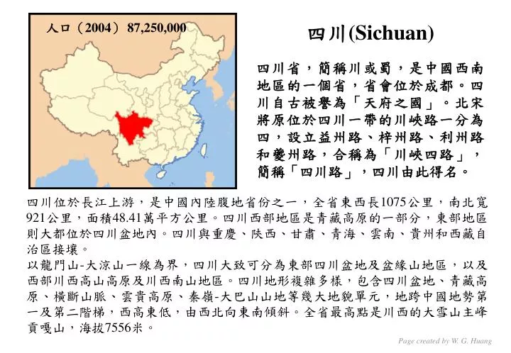
人口( 2004 ) 87,250,000. 四川 (Sichuan) 四川省,簡稱川或蜀,是中國西南地區的一個省,省會位於成都。四川自古被譽為「天府之國」。北宋將原位於四川一帶的川峽路一分為四,設立益州路、梓州路、利州路和夔州路,合稱為「川峽四路」,簡稱「四川路」,四川由此得名。. 四川位於長江上游,是中國內陸腹地省份之一,全省東西長 1075 公里,南北寬 921 公里,面積 48.41 萬平方公里。四川西部地區是青藏高原的一部分,東部地區則大都位於四川盆地內。四川與 重慶 、 陝西 、 甘肅 、 青海 、 雲南 、 貴州 和西藏自治區接壤。

E N D
人口(2004) 87,250,000 四川(Sichuan) 四川省,簡稱川或蜀,是中國西南地區的一個省,省會位於成都。四川自古被譽為「天府之國」。北宋將原位於四川一帶的川峽路一分為四,設立益州路、梓州路、利州路和夔州路,合稱為「川峽四路」,簡稱「四川路」,四川由此得名。 四川位於長江上游,是中國內陸腹地省份之一,全省東西長1075公里,南北寬921公里,面積48.41萬平方公里。四川西部地區是青藏高原的一部分,東部地區則大都位於四川盆地內。四川與重慶、陝西、甘肅、青海、雲南、貴州和西藏自治區接壤。 以龍門山-大涼山一線為界,四川大致可分為東部四川盆地及盆緣山地區,以及西部川西高山高原及川西南山地區。四川地形複雜多樣,包含四川盆地、青藏高原、橫斷山脈、雲貴高原、秦嶺-大巴山山地等幾大地貌單元,地跨中國地勢第一及第二階梯,西高東低,由西北向東南傾斜。全省最高點是川西的大雪山主峰貢嘎山,海拔7556米。 Page created by W. G. Huang
Earthquake Information European-Mediterranean Seismological Centre Summary: 200805120627 Mw=7.9, D=10 km Credit EMSC Page created by W. G. Huang
The rugged Sichuan Tarim Tibetan Plateau Sichuan Himalayan Mountain Range Credit DigitalGlobe Page created by W. G. Huang
Tibetan Plateau Himalayan Mountain Range The Himalayan Mountain Range runs a curving path from west to east in this true-color image. In this image, the Range separates southeastern China from India, and runs through (from left to right) northwestern India, Nepal, a small bit of northeastern India, and Bhutan. Credit NASA Page created by W. G. Huang
Tibetan Plateau Epicenter Sichuan India Burma Vietnam Laos Credit INGV
Epicenter Credit NASA Page created by W. G. Huang
Earthquake Near Chengdu, China (as of May 2008) This elevation map shows the region where the earthquake struck. Elevations—green indicating the lowest, and beige indicating the highest—are based on data collected by NASA’s Shuttle Radar Topography Mission (SRTM) flown in 2000. Credit NASA Page created by W. G. Huang
Regional seismicity before the main shock From 12/05/2006 to 12/05/2008 2 events with magnitude <=5.2 Credit EMSC Page created by W. G. Huang
Aftershocks distribution (From main shock to 15/05/2008) 72 events with magnitude M>=4.5; None with M>6 The aftershocks are distributed along an approx. 300 km long North-East direction which is consistent with the mechanisms reported by Harvard and the USGS as well as with the regional topography. As the main shock epicentre is located at the South-West end of the aftershock distribution, the main shock rupture propagated towards the North-East. MOMENT TENSORS SOLUTIONS Credit EMSC Credit EMSC Page created by W. G. Huang
Aftershock Animation 蘭州 九寨溝 汶川 綿陽 成都 都江堰 重慶 昆明 Page created by W. G. Huang Credit GFZ Potsdam
Affected Areas (受地震影響的範圍) 2008 Sichuan earthquake Page created by W. G. Huang
China: Mapping the earthquake zone 北川 汶川 綿竹 綿陽 映秀 德陽 什邡 都江堰 成都 Credit BBC Page created by W. G. Huang
川西鎖鑰 195 km Page created by W. G. Huang
臥龍保護區 Page created by W. G. Huang
8000 feared dead 20,000 injured China: Earthquake (as of 12 May 2008) - Situation Map Epicentre Mw=7.9 Time 2:28 (local time) 80% of houses destroyed • Communication facilities, roads, houses damaged • Areas unreachable • Landslides reported Beichuan Middle school collapsed And over 50 students Reported dead 900 student buried Wenchuan Credit ReliefWeb Page created by W. G. Huangc
15,000 dead 64,746 injured 25,000 buried 14,000 missing 80% of houses destroyed Beichuan Mianyang (7,395 dead) • Communication facilities, roads, houses damaged • Troops reached epicentre by parachute Wenchuan Chengdu Middle school collapsed And over 50 students Reported dead 900 student buried 959 dead Rescue teams tricking into worst hit area north of Chengduc China: Earthquake (as of 14 May 2008) - Situation Map Credit ReliefWeb Page created by W. G. Huangc
189 deads China: Earthquake (as of 16 May 2008) - Situation Map • Communication facilities, roads, houses damaged • Troops reached epicentre by parachute Wenchuan Chengdu 959 dead Rescue teams tricking into worst hit area north of Chengduc Credit ReliefWeb 21,500 dead 150,000 injured 14,000 buried 13,400 pulled out alive from debris 571,400 houses collapsed 279,900 houses destroyed 5.7 million people evaccuated Page created by W. G. Huangc
Credit ReliefWeb 67,183 dead 361,822 injured 20,790 missing 45.61 million affected 5.9 million homes damaged 5.46 million homes destroyed 15 million relocated Credit ReliefWeb Page created by W. G. Huangc
Detected radar anomalies (possible damages to buildings infrastructures) 都江堰 Credit ReliefWeb Page created by W. G. Huang
Landslide Road damaged by landslide Flooded area Buildings destoryed Buildings and roads destoryed Page created by W. G. Huang
Road damaged by landslide Buildings destoryed Buildings destoryed Flooded area Landslide Page created by W. G. Huang
Tectonics of the May 12 Sichuan earthquake Page created by W. G. Huang Credit GFZ
中評社香港5月17日電/台灣“中央大學”地球科學系教授王乾盈說,四川強震成因被認為“漸歸沉寂”的龍門山斷層“復活”發生錯動,這個斷層自明朝以來錄得震動的數據不多;本月12日的錯動使當地地殼抬升九公尺,“喜馬拉雅山也隨之長高好幾公尺”。中評社香港5月17日電/台灣“中央大學”地球科學系教授王乾盈說,四川強震成因被認為“漸歸沉寂”的龍門山斷層“復活”發生錯動,這個斷層自明朝以來錄得震動的數據不多;本月12日的錯動使當地地殼抬升九公尺,“喜馬拉雅山也隨之長高好幾公尺”。 王乾盈說,四川過去百年來發生的大小地震,只有少數跟龍門山斷層有關,規模不大,“以前長時間地震釋放的能量,幾乎都被同在四川的鮮水河斷層消耗掉”,地震專家都以為龍門山斷層的傷口癒合,不可能再動了。 每秒裂3公里 裂動一百秒 王乾盈分析,龍門斷層破裂面,從震央汶川縣往北東方向以每秒3公里速度裂向廣元,足足花一百秒裂完,震災範圍長240公里、寬30公里,尤其以破裂至北川縣時錯動得特別厲害。 三板塊夾擠 地殼抬升9米 王乾盈認為,四川地震是因夾在西藏地塊、崑崙地塊、揚子地塊,這三個地塊間的松潘甘孜地塊,向揚子地塊逆衝而上,“年輕的蓋在老的上面”,龍門山斷層要幾千年才會有這麼大的錯動,這次錯動使地殼抬升九公尺,“喜馬拉雅山至少因此長高幾公尺”。 Page created by W. G. Huang
POSTED BY KIM AT 8:27 PM KIM HANNULA I'm a forty-something tenured geology professor at a small public college in the Rockies. I love mountains - hiking in them, looking at them, studying them. You can reach me at shear sensibility at gmail dot com. My opinions are my own - not my employer's, not my students', not my spouse's, not my graduate advisor's... just mine. By KIM HANNULA Page created by W. G. Huang
MIT's tectonicist Clark Burchfield is quoted in the NY Times as being surprised that an earthquake of that magnitude (which requires a lot of fault to have moved at once) occurred in this particular spot. But although the size might be larger than one would expect, the type of earthquake isn't. This isn't a classic plate boundary earthquake, but it's part of the way that continents respond to continent-continent collisions. In the big picture, India is moving northward and colliding with Asia. That's what created the immense mountains of the Himalayas, and the highlands of the Tibetan Plateau, in the first place. This earthquake, however, was not on the plate boundary itself. It was off on the eastern edge of the Himalayas, on the boundary between the high country and the Sichuan basin. Here's the USGS earthquake location map. The pink lines represent the collisional plate boundaries - the boundary between India and geologic Asia runs along the southern end of the Himalayas. This earthquake was within Asia proper. By KIM HANNULA Page created by W. G. Huang
By KIM HANNULA Page created by W. G. Huang
But continents are... well, continents are kind of wimpy, actually, in terms of deformation. They're made of rock that's easier to break than oceanic crust is. And on top of that, they're thick. And when they run into one another, the continental crust gets even thicker. And that thick, weak crust can break within itself - it doesn't behave like the classic rigid plates that "plate tectonics" is named for. The crust of Asia breaks in a number of different ways. Parts of it are squeezed out, especially to the east, where it can run over the subducting Pacific plate like a semi over a squirrel. Parts of it actually stretch east-west, creating features like Lake Baikal up in Russia. Parts are pushed over each other, making the height of the Himalayas and Tibet possible. And parts are squeezed over other parts of Asia. And that's what's happening on the northwestern side of the Sichuan basin - the edge of the Tibetan Plateau is running over eastern Asia, in this case, along a classic thrust fault, sloping about 30 degrees down into the ground beneath the edge of the mountains. You can also see the movement of Tibet in this map of GPS velocities: By KIM HANNULA Page created by W. G. Huang
Each of the arrows represents the movement of a GPS monitoring site compared to the rest of Eurasia. The southern Himalayas are moving north; the Tien Shan mountains, north of the Tarim basin (white, north of the Himalayas) are moving much more slowly, and the eastern Himalayas... are moving east. Or even south. And at the Sichuan basin, that green blob east of the Himalayas, the GPS velocities drop. There's a change in movement. And that M 7.9 earthquake took place where the change occurs. The map of GPS velocities(From Gan, Zhang, Sun, and Sun, 2006) By KIM HANNULA Page created by W. G. Huang
The Google earth image (from the USGS Google earth KML) of the earthquake and its aftershocks shows the setting closer-up: It looks like the earthquake was on the basin-bounding fault. It looks like there are ridges in the basin running parallel to the fault, too - ridges that are cut by rivers. They are probably actively growing folds... which means there are probably active thrust faults running underneath the basin itself, not just under the mountains. Those faults, at least, don't seem to have moved. By KIM HANNULA Page created by W. G. Huang
PRESS RELEASE 16th May 2008 Scientists identified earthquake faults in Sichuan, China Only last summer research published by earth scientists in the international journal Tectonics concluded that geological faults in the Sichuan Basin, China“are sufficiently long to sustain a strong ground-shaking earthquake, making them potentially serious sources of regional seismic hazard." An international team of scientists including Dr. Alexander Densmore (Durham University), Dr. Mike Ellis (British Geological Survey) and colleagues from research institutes in Chengdu, carefully mapped and analysed a series of geologically young faults that cross Sichuan Province like recently healed scars. The team mapped the densely populated Sichuan Basin and adjacent mountains using what is known as ‘tectonic geomorphology’. This technique can demonstrate significant changes in ground movement over time, such as observations of offset river channels, disrupted floodplains, abnormally shaped valleys and uplifted landscape features. These subtle signals of deformation, when combined with the ability to measure the age of the disfigured landscapes (using cosmogenic nuclides that bombard the Earth from all corners of the universe), produced surprising results. Credit BGS Page created by W. G. Huang
The recent earthquake in Sichuan occurred under some of the steepest and most rugged mountains in the world, the Longmen Shan: the Dragon's Gate Mountains. This dramatic range, steeper than the Himalayas, is the upturned rim of the eastern edge of Tibet, a plateau that has risen to 5 km in response to the slow but unstoppable collision of India with Asia that began about 55 million years ago and which continues unabated today. Two long faults in particular, running almost the entire length of the Longmen Shan, showed clear evidence of slip during the last few thousands, and in some cases hundreds, of years. The rates of slip varied between fractions of mm per year to possibly many mm per year. Millimetre by millimetre, the Longmen Shan are being sliced and displaced much like salami. One of these faults is likely to be the one that gave rise to the 7.9 magnitude earthquake that has now caused 22,069 fatalities. Exactly why the Longmen Shan are here is a mystery. Unlike the Himalaya, which form the southern boundary of Tibet and whose faults chatter continuously with small earthquakes, faults in the Longmen Shan, remnants perhaps of geological events hundreds of millions of years ago, have historically only produced earthquakes up to magnitude 6. Geomorphological evidence suggests that the mapped faults are very steep with dominantly lateral or strike-slip displacements taking place over time scales of thousands to hundreds of thousands of years. This contrasts with shorter-term measurements using GPS which suggest a greater proportion of thrust or shortening displacement than lateral displacement. The observations of seismologists at the BGS suggest both things: more thrust in the SW, nearer the epicentre, and more strike-slip toward its direction of propagation, the NE. Credit BGS Page created by W. G. Huang
Map showing seismicity and faulting in the eastern Tibetan plateau region (magnitudes 7.0 and greater labelled). Credit BGS
1718 7.5 1654 8.0 1879 8.0 1976 7.2 1933 7.5 Credit BGS
Map showing the distribution of aftershocks following the magnitude 7.9 Mw in Eastern Sichuan on 12 May 2008 (magnitudes 4.5 and greater). Credit BGS
Coulomb Failure Stress variation & Vertical displacement by José A. Álvarez Gómez (Instituto Geografico Nacional, Madrid, Spain) Page created by W. G. Huang
Thanks to the finite fault model provided by the USGS, the author computed the Stress variations and the vertical deformation at the surface promoted by the fault rupture. The equations of Okada (1992), which describe the deformation in a homogeneous elastic half-space due to a rectangular dislocation, and Hooke's law were used to compute the stress tensor. The Coulomb Failure Stress variation (DCFS) was calculated on fault planes equal to the one of the main shock, at a depth of 10 km, that could rupture in the future and is defined as DCFS=T-m'(Sn), where T and Sn are the shear and normal stresses acting on the dislocation respectively, and m' is the assumed apparent friction coefficient of the fault plane (in this case 0.5). Page created by W. G. Huang by José A. Álvarez Gómez (Instituto Geografico Nacional, Madrid, Spain)
Rupture model of Mw=7.9 08/05/12 Sichuan earthquake Page created by W. G. Huang
Earthquake Research Institute, Univ. of Tokyo The Eastern Sichuan Earthquake (preliminary finite fault model) Teleseismic stations used in inversion. The star represents the epicenter of the main-shock Comparison of the observed waveform (Black) with the calculated waveform (Red). The numbers below the station code indicate maximum amplitude in microns. (Analyzed by KazutoHikima, Earthquake Research Institute, Univ. of Tokyo) Page created by W. G. Huang
Surface projection of the slip distribution (Analyzed by KazutoHikima, Earthquake Research Institute, Univ. of Tokyo) Page created by W. G. Huang
Slip distribution on the fault The largest slip occurred at 40 to 60 km north from the hypocenter, and some more asperities (i.e. local maxima of slip)can be also seen. The length and width of the fault are presumed to be 230 km and 40 km, respectively, according to the slip distribution. (For the analyses, we assumed 320 km and 40 km from the aftershock distribution.) The duration time (i.e. time to complete the rupture on the fault) is estimated to be 100 to 120 sec. (Analyzed by KazutoHikima, Earthquake Research Institute, Univ. of Tokyo) Page created by W. G. Huang
Kunlun earthquake in 2001 Longmenshan thrust zone Adapted from He and Tsukuda, 2003 Page created by W. G. Huang
The Longmenshan thrust zone is approximately 60 km wide, and constitutes the topographic boundary between the eastern Tibetan Plateau and the Sichuan basin. The total vertical slip rate is about 1-2 mm/yr, and thus the convergence rate across the thrust zone is inferred to be 4-6 mm/yr. The northward indentation of the Indian plate into the Tibetan crust after the collision between the Indian and Eurasian plates induced uplift and deformation of the Tibetan Plateau. The continental crust of China, thus, is highly active tectonic area. This continuing northward indentation resulted in three types of tectonic deformation: convergence zones surrounding the plateau, strike-slip fault zones associated with the laterally extruding crustal blocks in the eastern plateau (i.e. Kunlun earthquake in 2001), and extensional basins in the southern plateau on which the Longmenshan fault is located. (Analyzed by KazutoHikima, Earthquake Research Institute, Univ. of Tokyo) Page created by W. G. Huang
Waveforms Recorded at Taipei Basin Downhole Seismic Network The locations of the downhole arrays and their relationships to the faults around the Taipei metropolitan area. The accelerographic arrays with pink-square are in operation. The broadband arrays are triangulated. Page created by W. G. Huang
The particle velocities recorded at SNJB at level -100 meters. E N Z Installation of SNJB was completed in November 2007. 10 min. Page created by W. G. Huang
200805122008 Mw=5.5 200805120628 Mw=7.9 The particle velocities of EW component recorded at DANB at level -90 meters. 200805121111 mb=5.7
200805120628 Mw=7.9 P S