Download
1 / 28
300 likes | 404 Views
Global Precipitation Mission. Paul Joe Meteorological Service of Canada. Outline. Global Precipitation Mission European GPM Canadian GPM Retrievals and Validation. The GPM Mission Objectives.

E N D
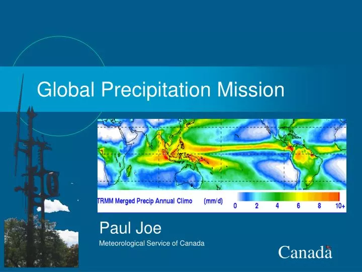
Global Precipitation Mission Paul Joe Meteorological Service of Canada
Outline • Global Precipitation Mission • European GPM • Canadian GPM • Retrievals and Validation
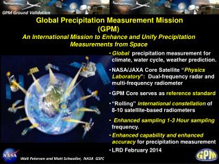
The GPM Mission Objectives • International Set of Cooperative Satellite Missions & Associated Scientific Research-Applications Programs • Better Understand Global Water & Energy Cycle • Obtain Improvements in Prediction of Significant Climate, Weather, & Hydro-meteorological Processes • Particularly Water Cycle Accelerations/Decelerations, • Tropical Cyclones & Severe Storms, • Flood Hazards, Seasonal Flood-Drought Conditions, • Stores of Fresh Water Resources
OBJECTIVES • Understand horizontal & vertical structure of rainfall, its macro- & micro-physical nature, & its associated latent heating • Train & calibrate retrieval algorithms for constellation radiometers • Provide sufficient global sampling to significantly reduce uncertainties in short-term rainfall accumulations • Extend scientific and societal applications The GPM Concept Core Constellation • Core Satellite • Non-sun-synchronous orbit • ~ 65° inclination • ~400 km altitude • Dual frequency radar (NASDA) • X-Ka Bands (13.6-35 GHz) • ~ 4 km horizontal resolution • ~250 m vertical resolution • ~ 18 dBZ MDS(CGPM 0 dBZ ?) • Multifrequency radiometer (NASA) • 10.7, 19, 22, 37, 85,(150/183 ?) • Constellation Satellites • Pre-existing operational-experimental & dedicated satellites with PMW radiometers • Revisit time • 3-hour goal at ~90% of time • Sun-synch & non-sun- synch orbits • 600-900 km altitudes • Precipitation Validation Sites for Error Characterization • Select/globally distributed ground validation “Super sites” (research quality radar, up looking radiometer-radar-profiler system, raingage-disdrometer network, & T-q soundings)(Snow) • Dense & frequently reporting regional rain gage networks (Snow, DSDs) • Microphysical aircraft measurements and field campaigns (ERAF, Cloudsat)
EGPM The EGPM mission goal is to retrieve precipitation with an emphasis on Europe and Canada. The EGPM mission will be an integral and essential component of the GPM constellation. • Improve the accuracy of global precipitation estimates with a focus on light rain and snowfall; • Improve global and regional NWP and climate modelforecasts; • Improve the near-real-timemonitoring of hazardous and flash-flood producing storms.
EGPM/CGPM • Focus on snow and light rain • Increased sensitivity requirements • High Sensitivity Radar • Sounding microwave channels • Ground Validation • Focus on solid precipitation
EGPM/GPM and Precipitation EGPM will extend precipitation observations to high latitudes
At higher latitudes: • larger fraction of precipitation is 'light' • percentage of solid • precipitation high CDF’s of Snowfall and Light RainDetection Requirements Snowfall Intensity Rainfall Intensity Occurrence Accumulation
EGPM instruments Needs Techniques Horizontal fields of precipitation Microwave imaging in 18 to 150 GHz windows Microwave radiometer Accuracy enhancement for light liquid and solid precipitation Microwave sounding in 50-60 GHz & 118 GHz bands High Sensitivity Profiles of precipitation Microwave backscattering at 36 GHz Precipitation Radar Observation Technique Active/passive microwave sensing well established Innovation: imaging + sounding + radar
Retrieval Simulation Error at surface 86% 61% 38% 13% 18, 23, 36 and 89 GHz: differentiation between rain and snow + 150 GHz: estimates of rain and snow + 50-60 and 118 GHz: quantitative retrievals + radar: accurate profile retrieval Reference
Ground Validation Objectives • To scientifically verify and continuously improve satellite retrieval algorithms. • To establish measurement uncertainties in precipitation retrievals. • To pursue precipitation validation research -- particularly of physical kind. • To advance GV measurement technologies. • To serve scientific clients who depend upon GV information in their research and applications, e.g.: • near-realtime retrieval error characteristics for data assimilation • error detection/reporting in instantaneous retrievals for algorithm developers
GPM Continental SupersiteRequirements & Concept • Provide physical validation and error statistics for algorithms; demand error statistics for all measurements at supersite. • Provide data so that algorithms can develop diagnostics to identify sources of error. • Perform basic science. Initial thrust would be to identify relationship between large scale variables and precipitation regime/precipitation structure. • Science thrust would relate large scale parameters (low-level wind direction, CAPE, etc.) to precipitation type (convective, stratiform, ice-based, warm rain, etc.). TRMM has taught us that biases in the satellite algorithms are not only due to systematic algorithm errors, but also by changing cloud properties. Need this information so that these types of errors can be minimized and serve as guidance for algorithms. • Provide motivation for field measurements to address specific algorithms problems,biases, etc.
Sodankylä Cabouw Chilbolton Bonn Oberpfaffenhofen Palaiseau Graz Cevennes-Vivarais Rome Catalunya An ExampleEurope • Various Precipitation Regimes • Various National Weather Services • Various Research Organizations • Various Radar Networks • Various Sites suited for Ground Validation ONE AIM: Ground Validation for GPM and EGPM
Potential GV Supersites Cabouw Chilbolton Palaiseau Oberpfaffenhofen Rome Catalunya Graz
Instrumentation of Supersites The proposed European supersites have excellent instrumentation and are well experienced in the development and operation of the systems and the organization of field campaigns. • Radar systems (S, C, X, Ka, W - Band) (Ku ?) co-located systems, some systems are mobile (airborne, truck) • Multi-frequency radiometer systems • Lidar systems, ceilometers • Windprofiler, RASS, Sodar • Surface observations • Disdrometers, rain gauges • Rain gauge networks • Operational radio sondes nearby • Lightning detection systems • Research aircraft • ...
Spatial RepresentativenessFundamental Measurement Validation Problem Radar Only Radar matched to rain gage Gage only What is the truth? Need for measurement AND physical validation of GPM!
Current Status of Potential GPM Ground Validation Site Network Finland U.K. Germany Japan -- CRL-North Wakkanai Canada Netherlands Austria South Korea U.S. -- NASA-Land DOE/ARM-SGP France Italy Greece China C Japan -- CRL-South Okinawa Spain-Catalunya Israel U.S. -- NASA-KSC Taiwan West Africa (AMMA) India U.S. -- NASA-Ocean Kawajalein/RMI Brazil South Africa Australia Existing or Potential Standard GV Site Existing or Potential GV Supersite
Snowfall Issues • In situ - Measurements – wind effects • Remote Sensing Technologies • Snowfall measurement in mountainous regions; • Snow bands off open water; • Measurement of low intensity solid precipitation events; • Solid precipitation over sea ice and ice covered Arctic Ocean; • Depth & Snow Water Equivalent (Z-S relationship); • Wind drift problem for snow.
Physical ValidationDrop Size Distributions DSD from POSS, JW and PMS
Cloudsat Linkages • Cloudsat Mission is CGPM Pre-launch • Algorithm development • Cal-val strategy development test-bed for GPM • Measurement and physical validation strategy testing • Cal-Val infrastructure the same (double the investment value) • Super sites, field campaigns, people • High sensitivity VPRs • Same radar technology • GPM Pre-Launch Activities – NAST-M
Summary • GPM ~2011 • Global precipitation measurements • 3 hour, various spatial resolutions • Constellation of radiometers, Core satellite with radar • 65o/87o latitude • EGPM/CGPM • Focus on snow and light rain • Not selected as part of Earth Explorer/Opportunity • Recommended for EarthWatch/part of GEO strategy • Cal/Val • Measurement and Physical Validation • Extensive instrumentation • Focus on error characterization • Little experience with snow