Download
1 / 1
10 likes | 181 Views
Selmin Burak 1 and Riad Meddeb 2 1 Istanbul University, Institute of Marine Sciences and Management, Muskule Sok. No:1 Vefa/Istanbul , Turkey e-mail: sburak@istanbul.edu.tr 2 UNDP , Senior Economic Advisor , Maison des Nations Unies , B.P: 648 Moroni Hamramba , Union des Comores

E N D
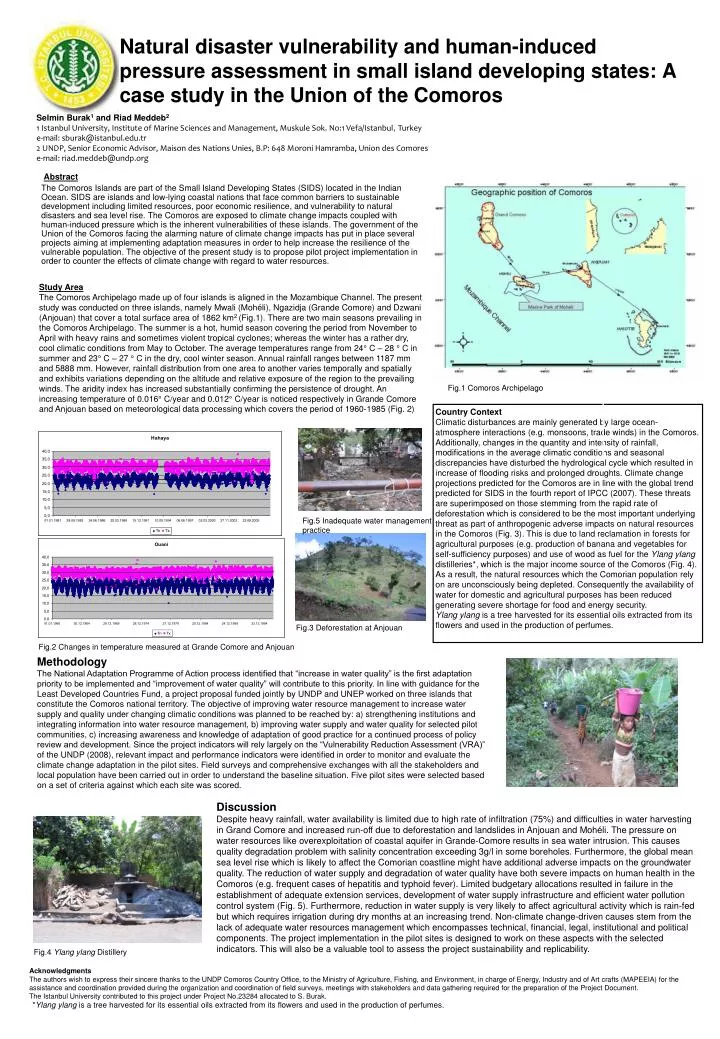
Selmin Burak1and Riad Meddeb21 Istanbul University, Institute of Marine Sciences and Management, Muskule Sok. No:1 Vefa/Istanbul, Turkey e-mail: sburak@istanbul.edu.tr2 UNDP, Senior Economic Advisor, Maison des Nations Unies, B.P: 648 Moroni Hamramba, Union des Comores e-mail: riad.meddeb@undp.org Study Area The Comoros Archipelago made up of four islands is aligned in the Mozambique Channel. The present study was conducted on three islands, namely Mwali (Mohéli), Ngazidja (Grande Comore) and Dzwani (Anjouan) that cover a total surface area of 1862 km2 (Fig.1). There are two main seasons prevailing in the Comoros Archipelago. The summer is a hot, humid season covering the period from November to April with heavy rains and sometimes violent tropical cyclones; whereas the winter has a rather dry, cool climatic conditions from May to October. The average temperatures range from 24° C – 28 ° C in summer and 23° C – 27 ° C in the dry, cool winter season. Annual rainfall ranges between 1187 mm and 5888 mm. However, rainfall distribution from one area to another varies temporally and spatially and exhibits variations depending on the altitude and relative exposure of the region to the prevailing winds. The aridity index has increased substantially confirming the persistence of drought. An increasing temperature of 0.016° C/year and 0.012° C/year is noticed respectively in Grande Comore and Anjouan based on meteorological data processing which covers the period of 1960-1985 (Fig. 2) Natural disaster vulnerability and human-induced pressure assessment in small island developing states: A case study in the Union of the Comoros Fig.1 Comoros Archipelago Country Context Climatic disturbances are mainly generated by large ocean-atmosphere interactions (e.g. monsoons, trade winds) in the Comoros. Additionally, changes in the quantity and intensity of rainfall, modifications in the average climatic conditions and seasonal discrepancies have disturbed the hydrological cycle which resulted in increase of flooding risks and prolonged droughts. Climate change projections predicted for the Comoros are in line with the global trend predicted for SIDS in the fourth report of IPCC (2007). These threats are superimposed on those stemming from the rapid rate of deforestation which is considered to be the most important underlying threat as part of anthropogenic adverse impacts on natural resources in the Comoros (Fig. 3). This is due to land reclamation in forests for agricultural purposes (e.g. production of banana and vegetables for self-sufficiency purposes) and use of wood as fuel for the Ylang ylang distilleries*, which is the major income source of the Comoros (Fig. 4). As a result, the natural resources which the Comorian population rely on are unconsciously being depleted. Consequently the availability of water for domestic and agricultural purposes has been reduced generating severe shortage for food and energy security. Ylang ylang is a tree harvested for its essential oils extracted from its flowers and used in the production of perfumes. Fig.5 Inadequate water management practice Abstract The Comoros Islands are part of the Small Island Developing States (SIDS) located in the Indian Ocean. SIDS are islands and low-lying coastal nations that face common barriers to sustainable development including limited resources, poor economic resilience, and vulnerability to natural disasters and sea level rise. The Comoros are exposed to climate change impacts coupled with human-induced pressure which is the inherent vulnerabilities of these islands. The government of the Union of the Comoros facing the alarming nature of climate change impacts has put in place several projects aiming at implementing adaptation measures in order to help increase the resilience of the vulnerable population. The objective of the present study is to propose pilot project implementation in order to counter the effects of climate change with regard to water resources. Fig.3 Deforestation at Anjouan Fig.2 Changes in temperature measured at Grande Comore and Anjouan Methodology The National Adaptation Programme of Action process identified that “increase in water quality” is the first adaptation priority to be implemented and “improvement of water quality” will contribute to this priority. In line with guidance for the Least Developed Countries Fund, a project proposal funded jointly by UNDP and UNEP worked on three islands that constitute the Comoros national territory. The objective of improving water resource management to increase water supply and quality under changing climatic conditions was planned to be reached by: a) strengthening institutions and integrating information into water resource management, b) improving water supply and water quality for selected pilot communities, c) increasing awareness and knowledge of adaptation of good practice for a continued process of policy review and development. Since the project indicators will rely largely on the “Vulnerability Reduction Assessment (VRA)” of the UNDP (2008), relevant impact and performance indicators were identified in order to monitor and evaluate the climate change adaptation in the pilot sites. Field surveys and comprehensive exchanges with all the stakeholders and local population have been carried out in order to understand the baseline situation. Five pilot sites were selected based on a set of criteria against which each site was scored. Discussion Despite heavy rainfall, water availability is limited due to high rate of infiltration (75%) and difficulties in water harvesting in Grand Comore and increased run-off due to deforestation and landslides in Anjouan and Mohéli. The pressure on water resources like overexploitation of coastal aquifer in Grande-Comore results in sea water intrusion. This causes quality degradation problem with salinity concentration exceeding 3g/l in some boreholes. Furthermore,the global mean sea level rise which is likely to affect the Comorian coastline might have additional adverse impacts on the groundwater quality. The reduction of water supply and degradation of water quality have both severe impacts on human health in the Comoros (e.g. frequent cases of hepatitis and typhoid fever). Limited budgetary allocations resulted in failure in the establishment of adequate extension services, development of water supply infrastructure and efficient water pollution control system (Fig. 5). Furthermore, reduction in water supply is very likely to affect agricultural activity which is rain-fed but which requires irrigation during dry months at an increasing trend. Non-climate change-driven causes stem from the lack of adequate water resources management which encompasses technical, financial, legal, institutional and political components. The project implementation in the pilot sites is designed to work on these aspects with the selected indicators. This will also be a valuable tool to assess the project sustainability and replicability. Fig.4 Ylang ylang Distillery Acknowledgments The authors wish to express their sincere thanks to the UNDP Comoros Country Office, to the Ministry of Agriculture, Fishing, and Environment, in charge of Energy, Industry and of Art crafts (MAPEEIA) for the assistance and coordination provided during the organization and coordination of field surveys, meetings with stakeholders and data gathering required for the preparation of the Project Document. The Istanbul University contributed to this project under Project No.23284 allocated to S. Burak. *Ylang ylang is a tree harvested for its essential oils extracted from its flowers and used in the production of perfumes.