Download
1 / 24
240 likes | 423 Views
WRF (near) Real-Time High-Resolution Forecast Using Bluesky. Wei Wang May 19, 2005 CISL User Forum. Outline. A brief introduction of WRF Purposes of doing high-resolution WRF real-time forecasting Forecast experiments on bluesky Forecast examples: BAMEX, RT2004, RT2005, and hurricanes

E N D
WRF (near) Real-Time High-Resolution Forecast Using Bluesky Wei Wang May 19, 2005 CISL User Forum
Outline • A brief introduction of WRF • Purposes of doing high-resolution WRF real-time forecasting • Forecast experiments on bluesky • Forecast examples: BAMEX, RT2004, RT2005, and hurricanes • Benefits of these forecast experiments • Future
WRF • WRF stands for Weather Research and Forecasting model. It has been in development in the past few years. • It supports a variety of weather research and forecasting capabilities, with a strong emphasis on the 1 – 10 km grid spacing range. • The current release is WRF Version 2.
Purposes • Evaluate and test the model on daily basis for the following: • Ability to predict convective weather, its initiation, evolution and, to some extend, severity. • Ability to forecast intensity of hurricanes. • Evaluate if there are any values to the forecasting community.
WRF Forecasts • 2003: May 15 – July 10, 4 km • In support of field program BAMEX • 2004: Spring/Summer, Apr 25 – July 31, 4 km • 2005: Spring/Summer, Apr 15 – July 31, 4 km • Partially in support NOAA/SPC Spring Program • 2003 – 2004 Hurricane season: 4 major hurricanes: Isabel (03), Frances, Ivan and Jeanne (04), 4 km • 2004 – 2005 Winter (DWFE): Dec 1 – Mar 31, 5 km
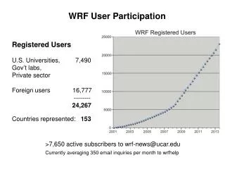
Computing Resources • IBM bluesky: • 128 – 256 processors, up to 6 wallclock hours per day • MSS: • up to 70 Gb per day
Forecast Domains 4km forecast domain, 2005
Convection Forecast Example Reflectivity, valid 5/30/03 23Z Composite NEXRAD Radar 23 h Reflectivity Forecast
Convection Forecast Example Reflectivity, valid 6/23/03 06Z Composite NEXRAD Radar 30 h Reflectivity Forecast
Convection Forecast Example Reflectivity, valid 5/25/03 06Z 30 h Reflectivity Forecast Composite NEXRAD Radar
Example: Radar reflectivity,24 h fcst vs obs, valid 0000 UTC May 13, 2005 WRF 4km NMM 4.5km WRF 2km observed http:// www.spc.noaa.gov/exper/Spring_2005
Values to Forecasting Community • For many forecasters, 2003 BAMEX data were the first convection-permitting forecasts in real-time they had used. • The success of the forecasts showed the operational community that there were definite values added by using these high-resolution forecasts.
Values to Forecasting Community Some forecasters’ statements: “.. This 4km WRF data has been very very useful to our operational forecasts, convective planning, and situation awareness.” “Overall, I found the 4km WRF output very valuable, especially the "dbz“ graphics. I more or less used it as a "quick look" for potential hazardous weather in my CWA. More often than not, the WRF outperformed the ETA20 and RUC with location and intensity of high plains thunderstorm activity.” “I would like to have the 4-km WRF running all year.”
WRF Hurricane Forecasts • Evaluate model’s ability to do tropical storm (TC) and hurricane forecast. • For example, tracks from 5-day forecasts • Can the use of high-resolution model improve the intensity forecast?
A Typical TC Forecast Domain 12 km 4 km
WRF Hurricane Forecasts Hurricane Ivan (2004): best track
Ivan at landfall: 0800 UTC, 16 Sep 2004 32 h forecast from 4 km WRF Mobile Radar
WRF Hurricane Forecasts Hurricane Isabel (2003): best track
Isabel at landfall: 1700 UTC Sept 18, 2003 WRF Obs 17 hr WRF WRF 41 hr 29 hr
Values to Developers • Strength and weakness of the model in any systematic way • Robustness of the model when doing various applications
Future • Larger grid, finer resolutions, and longer forecast • WRF 2 km, 30 h: produced by OU and done at the PSC, using 1100 processors • Can we do it here?
In the near Future • TCSP (Tropical Cloud Systems and Processes), July 2005 – to look at tropical storm genesis over Eastern Pacific • August / September, 2005: hurricane forecast • MIRAGE (Megacity Impacts on Regional and Global Environments): Spring 2006 Multiple domains with the finest one at 3 – 4 km
Acknowledgement Ginger Caldwell George Fuentes Marc Genty Siddhartha Ghosh Dick Valent
Relevant web pages WRF model: wrf-model.org Current WRF 4 km forecast: www.mmm.ucar.edu/projects/wrf_spring/ Current SPC Spring Program: www.spc.noaa.gov/exper/Spring_2005/