Download
1 / 23
230 likes | 364 Views
Registration of Geophysical Images. Alexandra A. Karamitrou Laboratory of Exploration Geophysics Aristotle University of Thessaloniki, Greece,. alexakara@geo.auth.gr. Maria Petrou Informatics & Telematics Institute, CERTH, Thessaloniki, Greece. petrou@iti.gr. Gregory N. Tsokas

E N D
Registration of Geophysical Images Alexandra A. Karamitrou Laboratory of Exploration Geophysics Aristotle University of Thessaloniki, Greece, alexakara@geo.auth.gr Maria Petrou Informatics & Telematics Institute, CERTH, Thessaloniki, Greece petrou@iti.gr Gregory N. Tsokas Laboratory of Exploration Geophysics Aristotle University of Thessaloniki, Greece gtsokas@geo.auth.gr ARISTOTLE UNIVERSITY OF THESSALONIKI FACULTY OF SCIENCES
Archaeology Geophysical methods Brizzolari et al., 1992a Garrison, 2003 Piro et al., 1998 Tsokas et al., 1994 The target is to increase the information obtained from the 2 original images independently.
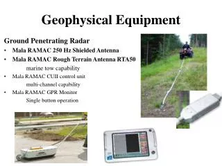
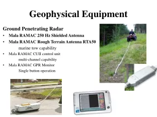
Magnetic method Instrument: Gradiometer sensors Detect magnetic anomalies produced by the existence of buried features
Electrical method Determines the underground resistivity anomalies Electrodes that measure the electric potential Electrodes that induce electric current
Archaeological area of Kampana (Maronia-NE Greece) Ceramic objects Ruins from the temple of Dionisos (323 - 146 B.C) Mosaic floor from an aristocratic house (323 - 146 B.C) Ancient Theater (323 - 146 B.C)
Archaeological area of Kampana (Maronia-NE Greece) Tsokas G. et al., 2004 Vertical Gradient of the local magnetic field Magnetic method Apparent Resistivity Electrical method
Archaeological area of Argos-Orestiko (West Greece) Aero photography by Κ. Κiriagos Ancient temple of Roman period (63 B.C – 476 A.D) and an old Christian church (450–600 A.D)
Archaeological area of Argos-Orestiko (West Greece) Tsokas et al., 2006 Vertical Gradient of the local magnetic field Magnetic method Apparent Resistivity Electrical method
Archaeological area of Argos-Orestiko (West Greece) Tsokas et al., 2006 Vertical Gradient of the local magnetic field Magnetic method Apparent Resistivity Electrical method
Need for Registration • GPS have accuracies up to 5m, depending on the quality of the receiver, number of satellites etc. • Measurements in fields with different obstacles • Hand held instruments • the data may have errors due to • inaccuracies during the measurements Electrical instrument Magnetic instrument
Image Preprocessing Original image Flagged image Flagging all the non-chartered pixels with a non realistic pixel value • No rectangular images • Unchartered patches in the interior due to obstacles
Training set Left column Vertical Gradient of the local magnetic field (magnetic method) Right column Apparent Resistivity (electrical method) Test data
Image Registration The geophysical images are from different modalities Mutual Information was used as a similarity measure We used a simplified version of the cost function (Kovalev V. A. and Petrou M., 1998), where exhaustive search is used to find the parameters of the global translation that would maximize the mutual information between the pairs of images as well as their overlapping area. Mutual Information 0.1204 Mutual Information 0.2234 Mutual Information 0.5431
Registration Results In all three cases the results agreed exactly with the known shift between the pairs of images from their geographical coordinates. Preliminary registration of training set Preliminary registration of test data
Affine Transformation Affine transformation is a linear 2-D geometric transformation which maps variables, through a linear combination of rotation, scaling and shearing followed by a translation, into new variables. Rotation Original Image Scaling Shearing
Proposed Methodology START Apply the affine transformation while we check the effect on the Mutual Information Randomly selected parameters for the affine transformation Registered Images (with the exhaustive search method) Randomly selected area Transformation is saved and the transformed image is updated Does the termination criterion has met ? STOP YES NO Is there improvement on the Mutual Information?
(2M+3)x(2M+3) Μ=1 (2M+1)x(2M+1) Μ=1 25 pixels 9pixels + + + + + + + o o o x x x o o o + + x x x + + x o o x o x + + + + + For the pixels at the places of the window with the maximum distortion, Parameter is calculated as, “continuity” parameter Selecting , the pixels at the periphery do not move much. The Delaunay triangulation method (Delaunay B., 1934) was used.
The randomly selected central pixel and the (2M+3)x(2M+3) window are selected with the condition that the whole window does not contain uncharted pixels.
Windows that succeed to increase the Mutual information Windows that fail to increase the Mutual information
Mutual Information Results Different values of mutual information for the training pair of images (Maronia). 0.5 0.98 The algorithm was run without any change of the parameters for the 2 testing pair of images Different values of mutual information for the two testing pair of images 0.57 0.76 0.8 1.46 Argos Orestiko 1st case Argos Orestiko 2nd case
Transformed Images Results Archaeological area of Kampana Archaeological area of Argos Orestiko
Conclusions Registration method with rigid body translations succeeded to register the geophysical images in agreement with the geographical coordinates. Local inaccuracies (offsets) during the measurements degrade the overall mutual information between the images. We introduced a new efficient and effective semi-stochastic optimization algorithm which applies randomly distortions with randomly selected parameters, and accepts the changes only when they help increase the mutual information between the images. We proposed a method that applies local distortion while preserves the continuity of the grid. We selected the parameters of the algorithm by using a training pair of images and then tested it, without changing these parameters on two other sets of images. In all cases the algorithm increased the mutual information between the images beyond the benchmark value of rigid body registration.
Thank you for your attention ! Alexandra A. Karamitrou Laboratory of Exploration Geophysics Aristotle University of Thessaloniki, Greece, alexakara@geo.auth.gr Maria Petrou Informatics & Telematics Institute, CERTH, Thessaloniki, Greece petrou@iti.gr Gregory N. Tsokas Laboratory of Exploration Geophysics Aristotle University of Thessaloniki, Greece gtsokas@geo.auth.gr