Download
1 / 14
140 likes | 277 Views
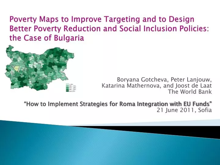
Poverty Maps to Improve Targeting and to Design Better Poverty Reduction and Social Inclusion Policies: the Case of Bulgaria. Boryana Gotcheva, Peter Lanjouw, Katarina Mathernova, and Joost de Laat The World Bank “How to Implement Strategies for Roma Integration with EU Funds”

E N D
Poverty Maps to Improve Targeting and to Design Better Poverty Reduction and Social Inclusion Policies: the Case of Bulgaria Boryana Gotcheva, Peter Lanjouw, Katarina Mathernova, and Joost de Laat The World Bank “How to Implement Strategies for Roma Integration with EU Funds” 21 June 2011, Sofia
Outline • The rationale for poverty maps in the context of Roma integration and use of EU funds • The emergence of poverty mapping • The poverty mapping experience in Bulgaria • The way forward: combining 2011 census information with EU-SILC survey information as a (potential) way to poverty mapping • Concluding remarks
More than a pretty picture… Poverty incidence in Bulgaria, LAU 1 level (‘nuts 4’) – 262 municipalities (2005)
Rationale for Poverty Maps • Not necessarily “maps”; rather, highly disaggregated databases of welfare indicators • Poverty and/or inequality • Average income/consumption • Calorie intake, under-nutrition • Other indicators (health outcomes, life-expectancy, education attainment) • Can be used for targeting, moreover disaggregation may, but need not, be spatial • Poverty of “statistically invisible” groups
Rationale for Poverty Maps • Poverty maps are an effective instrument for targeting of social inclusion interventions that go beyond cash social assistance • The cash social assistance beneficiaries are identified with a means test, however they usually experience multiple vulnerabilities, that can be reduced by combining cash transfers with enabling • Social care service • Employment services / active labor market programs • Housing projects • Regional development initiatives, etc. • Poverty maps allow geographic cross-check on enrollment to validate patterns in eligibility decisions
Emergence of Poverty Mapping • Program started late 1990s by the World Bank research department • “Small area estimation” methodology: a combination of highly disaggregated household-level micro data collected with HBS or LSMS, and all-encompassing census data • Methodological papers • Elbers, Lanjouw and Lanjouw (2003, Econometrica) • Hentschel et al. (2000) and ELL (2000, 2002) • Strong capacity building effort: poverty maps are now produced on a regular basis in all parts of the world • World Bank PovMap Software publicly available for small area estimation
The Case of Bulgaria: Poverty Incidence Maps (1) • Goals • Display spatial dimension of poverty and identify pockets of poverty • Serve a basis for targeting of disadvantaged municipalities for the purposes of poverty reduction • Implementation: Joint team (Data Users’ Group) • Leadership of the Ministry of Labor and Social Policy (MLSP) • Technical expertise of the National Statistical Institute (NSI) • Active involvement of leading Bulgarian academics • World Bank financing and technical assistance trough a Capacity Building Institutional Development Fund (IDF) grant • Outcomes • 2003 and 2005 poverty incidence maps • Book • Featured in “More than a Pretty Picture” book and conference
The Case of Bulgaria:Poverty Incidence Maps (2) • Methodology • Data sources: 2001 Census and 2001 and 2003 Bulgaria Integrated Household Surveys (BIHS), district level indicators • BIHS: 2,500-3,023 households, representative at NUTS 1 (Sofia, urban, rural level) • 30 common indicators between Census and BIHS • Standard “small-area estimation” procedure • Municipal level indicators estimated • Poverty rate, poverty depth, severity of poverty, and Gini coefficients
The Case of Bulgaria: Poverty Incidence Maps (3) Main Findings • Considerable variation in poverty levels across municipalities: 3%-40% of individuals • Considerable variation in poverty levels across municipalities within the same district • Poorest areas characterized by relatively higher shares of ethnic minorities (Roma and Turkish households) • Poorest areas characterized by lacking in: • human capital endowment (prevalence of people with low education attainment, or elderly pensioners), and • infrastructure
The Case of Bulgaria:Poverty Incidence Maps (4) • Policy use • Strategic poverty documents, e.g. • The National Plan for Poverty Reduction 2005-2006 • Strategy for Reduction of Poverty and Social Exclusion 2006-08 • District Development Strategies 2005-2015 • Targeting of antipoverty interventions • Program for Poverty Reduction in the (13) Poorest Municipalities • Targeting of Social Investment Fund (SIF) projects • included in a multi-dimensional continuous scoring formula applied for ranking of municipal proposals, along with other indicators • Social Investment and Employment Promotion Project (WB)
The Way Forward: New Poverty Incidence Maps • Combination of 2011 census and latest EU-SILC data • Household surveys like EU-SILC have breadthof indicators, but sample sizes too small to be representative for local area units • Population census doallow small areas calculations but frequently lack breadth of indicators necessary to calculate main poverty indicators
Small Area Estimation: CombineCensus and EU-SILC Information Step 1 Background characteristics unique to EU-SILC Common Household Background Characteristics EU-SILC or other detailed survey Household Welfare Indicator(s) such as at-risk-of-poverty in EU-SILC Step 0 Step 2 Household Welfare Indicator(s) such as at-risk-of-poverty not in census Common Household Background Characteristics National Population Census POVERTY MAP(S)
Concluding Remarks • Appropriate for targeting. Poverty maps can be very useful tool to target poorest areas with inclusion programs • Implementation history and available capacity. If data are available, production of poverty maps takes several months • Policy relevance and adoption of poverty maps are enhanced through considerable outreach and capacity building • A window of opportunity in Bulgaria and EU-wide: population censuses being implemented throughout the EU in 2011 and availability of annual EU-SILC survey data are promising
THANK YOU! bgotcheva@worldbank.org