Download
1 / 16
160 likes | 259 Views
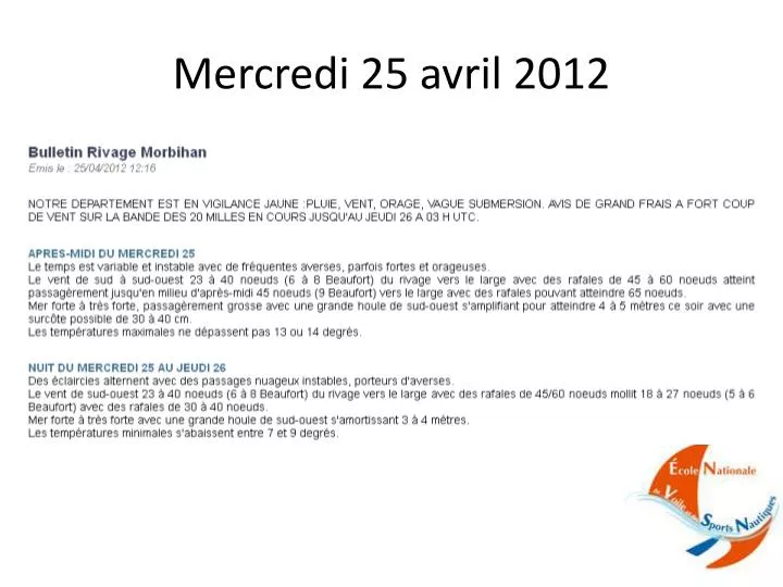
Mercredi 25 avril 2012. Mercredi 25 avril 2012. Mardi 24 avril à 20Hloc: - Arrivée du front chaud (voir carte iso mardi 24 avril18UTC et suivantes) Le vent continue sa rotation à gauche: 240° à 20H 160° à 01H, soit 16°/h, cad bonne rotation à gauche ( cf capteur de Groix)

E N D
Mercredi 25 avril 2012 Mardi 24 avril à 20Hloc: - Arrivée du front chaud (voir carte iso mardi 24 avril18UTC et suivantes) • Le vent continue sa rotation à gauche: 240° à 20H 160° à 01H, soit 16°/h, cadbonne rotation à gauche (cf capteur de Groix) • Le vent commence à forcir: 12nds à 20H 36nds à 03H, soit +24nds en 7H! • La pression commence à tomber à Lorient: 1004hPa à 20H 985hPa à 7H, soit une chute de près de 20hPa ds la nuit! soit 1,7hPa/h • Le ciel se couvre (cf cartes sat de mardi 24 à 16UTC et suivantes) • Mercredi 25 avril à 01Hloc: • Passage du front chaud au sol: secteur chaud (cf carte iso merc25 à 00UTC) • Le vent a fini sa rotation à gauche (cf capteur Groix) • Le vent continue de forcir (cf capteur Groix et carte iso) • La pression continue de baisser (cf capteur Lorient et cartes iso merc25 à 00UTC et 6UCT) • La température augmente légèrement (+2° entre 1H et 3H du matin !) • Mercredi 25 avril à 8Hloc: • Passage du front froid (voir carte iso mercredi 25 à 6UTC) • Le vent « mollit » brusquement pdt 2/3H à 28nds, puis forcit rapidement à 36nds moyen à 12H, raf45/50nds , jusqu’à 21Hloc (cf capteur de Groix et écartement isobarique) • Pas de brusque rotation à droite, légère droite sur la journée car pas de cassure isobarique, le front est quasi parallèle aux isobares (cf carte iso et capteur Groix) • Fin de la chute de la pression qui se stabilise avant de remonter vers 15hloc (cf capteur Lorient et cartes iso mercredi 25 à 12UTC et 18UCT) • Le ciel se dégage (cf cartes sat de merc25 à 6UTC)