Download
1 / 21
210 likes | 351 Views
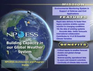
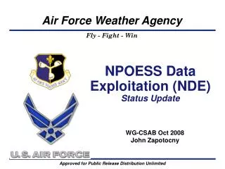
Environmental Monitoring System in Support of Defense and Civil Applications. Rapid data delivery 4x faster than legacy systems enables quicker reaction to changing conditions 10x the data of existing systems Accurate data - better forecasts International collaboration

E N D
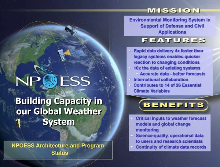
Environmental Monitoring System in Support of Defense and Civil Applications • Rapid data delivery 4x faster than legacy systems enables quicker reaction to changing conditions • 10x the data of existing systems • Accurate data - better forecasts • International collaboration • Contributes to 14 of 26 Essential Climate Variables Building Capacity in our Global Weather System • Critical inputs to weather forecast models and global change monitoring • Science-quality, operational data to users and research scientists • Continuity of climate data records • NPOESS Architecture and Program Status
NPOESS Environmental Monitoring Regimes Nowcasting, Forecasting • Routine weather, disasters, military ops Weather, Oceanography Clouds, temperature, wind, precipitation, currents, tides, land use Space Environment Auroral particles, high energy space radiation Climate Environment Chemistry, water, land use Space Environmental Monitoring • Anomaly resolution, human space flight safety Long Term Monitoring • Global change implications
NPOESS System Architecture Weather / Climate Products Supporting Space TDRSS GPS TDRSS Space Segment C11330 C21730 SARSAT LaunchSupportSegment NPOESSPreparatoryProject Offline Support • Algorithm Support • Integrated Support Facility • Calibration/Validation EELV A-DCS CLASS Weather Centrals SDS NAVO FNMOC AFWA NESDIS AlternateMMC Svalbard Primary T&C VAFB FNMOC Interface Data Processing Segment AFWA NESDIS Data Delivery Data Delivery Data Delivery Data Delivery NAVO DQM White SandsComplex LRD HRD MissionManagementCenter (MMC) Processing Processing Processing Processing Processing Field Terminal Segment DataManagement DataManagement DataManagement DataManagement 15 Globally Distributed Receptor sitesInterconnected by Commercial Fiber Ingest Ingest Ingest Ingest Mission Data Command, Control & Communication Segment TM Command & Telemetry NPOESS Mission Data NPP Mission Data
NPOESS Program Accomplishments: January – Apr 2009 NPOESS Preparatory Project (NPP) Payloads CrIS: environmental test completed, good performance results; Tiger Team reviewing impacts of parts issues on a circuit card VIIRS: proceeding into TVAC testing OMPS: Tiger Team reviewing disposition of screw torque issue Ground Successful end-to-end demo at AFWA Operations Completed NPP Mission Operations Readiness Review System Engineering Completed Early Engineering Space-to-Ground testing Sensor Performance analysis results - meets or exceeds KPPs and EDRs NPOESS Payloads OMPS F2: nadir spectrometers aligned VIRS F2: procurements in progress CrIS F2: procurements in progress SEM-N: SRR completed to deliver before C1 need date MIS: NRL on contract to deliver before C2 need date ADCS & SARSAT: in production and on track TSIS: sensor on contract with LASP Ground/Ops Operations & Sustainment Critical Design Audit - cleared to proceed to NPOESS System Critical Design Review (CDR) Space Segment Completed Space Segment CDA 23 Feb-6 March as planned at restructure 85 of 85 design reviews completed Delivered Spacecraft Control Processor (SCP) System Engineering Completed the Operations and Sustainment (O&S) Critical Design Audit (CDA) CERES Delivered OMPS Delivered CrIS TVAC Complete VIIRS EMI and Vibe Complete IDPS at NESDIS Complete IDPS AFWA Complete NPOESS SBC Eng model delivered
NPOESS Payload Development Status CrIS Instrument (ITT) VIIRS Instrument (Raytheon) OMPS Instrument (Ball) Cross-track Infrared Sounder • with ATMS provides atmospheric temperature, moisture, and pressure profiles • Flight 1 sensor completed environmental and performance testing • Performance meets or exceeds EDR requirements • Parts issues at ITT require rework of a single circuit board • Upcoming: Pre-Ship Review for NPP spacecraft planned for Jul 2009 Visible/Infrared Imager/ Radiometer Suite • provides 22 EDRs of atmospheric and surface environmental data • Flight 1 ambient, EMI and vibration testing completed • Proceeding into TVAC environmental test • Upcoming: VIIRS F1 in TVAC • Pre-Ship Review scheduled for this fall Ozone Mapping & Profiler Suite • provides ozone data • Flight 1 integrated on NPP spacecraft • Tiger Team reviewing disposition of screw torque issue
NPOESS Payload Development Status ATMS Instrument (NGES) CERES Instrument (NGST) TSIS Instrument (LASP) Advanced TechnologyMicrowave Sounder • with CrIS provides atmospheric temperature, moisture, and pressure profiles • Flight 1 integrated on NPP in 2005 Clouds and Earth’s Radiant Energy System provides data on incoming and outgoing radiant energy • Flight Module 5 integrated on the NPP spacecraft in Nov 08 Total Solar Irradiance Sensor provides data on the amount of energy emitted by the Sun incident on Earth • Approved by EXCOM for C1 satellite on 1 May 2008 • LASP on contract to delivery sensor in June 2012, within C1 need date
NPOESSPayload Development Status Tx Antennas Receive Antenna Energetic Particle Spectrometer (EPS) Medium-energy detector Special Sensor J5 (SSJ5-N) Low-energy detector SAR Repeater (DND) Receiver Processing Unit (RPU) Transmitter Unit (TXU) High Energy Sensor (HES) MIS Instrument (NRL) SEM Instrument (JHU/APL) A-DCS (CNES) & SARSAT (DND) Microwave Imager Sounder • provides soil moisture and sea surface winds • System Requirements Design Review in May • Flight 1 Critical Design Review in 2011 with delivery in 2014 providing adequate margin to the C2 satellite need date Space Environmental Monitor provides data on charged particles entering the Earth’s atmosphere • Systems Requirements Review successfully completed in Feb 2009 • On track to deliver by June 2012, within C1 need date • Advanced Data Collection System &Search and Rescue Satellite-Aided Tracking • monitors data from unmanned sites & relays distress signals from mariners and aviators in distress • SAR Processor unit complete • SAR Receiver unit CDR in 2009 • A-DCS 4 PDR completed in Mar (High heritage from A-DCS 3)
Data 1 Volume Spectral Capability Vertical Resolution Improvements Over Heritage Data Rate Encryption Heritage 1.5 Mbps 6.3 GB/Day Total 5 bands 40 bands NPOESS 20 Mbps 5.4 TB/Day Selective 22 bands 1300 bands Data Delivery DATA LATENCY – Delivery of Data to Users DMSP/POES NPP NPOESS 100 – 150 minutes 140 minutes 28 minutes 1 Data Volume per Satellite NPOESS improves robustness, accuracy, and timeliness of delivery of essential weather and climate data
NPOESS McMurdo Activity • “Off-Ice” Communications Infrastructure • Leverages OPTUS SATCOM link from Antarctica to Australia • Link has been active since December 2007 to support NSF • End state is 60 Mbps outbound/20 Mbps inbound service to support NSF, NPOESS • Final phase scheduled to complete in 2009-2010 work season • Installation of NPOESS Stored Mission Data (Ka-Band) Receptors • Antenna pad #1 completed 2008-2009 work season • Antenna pad #2 scheduled to complete in 2009-2010 work season • Antenna installations scheduled for 2011-2012 work season • Enhancement of NASA’s McMurdo Ground Station (MGS) • MGS is 10-meter antenna system with X/S-band receive/tracking capability • NASA upgrading MGS to support MetOp stored mission data (receive-only) • Upgrade scheduled for 2010-2011 work season • Implementation of Multi-Mission Communications and additional ground station capability • Contract award expected July 2009 • Baseline tasks are upgrades to support routing of MetOp data to Darmstadt • Scheduled to complete in 2010-2011 work season • Includes option to implement a DMSP data recovery and relay capability • Adds S-band receive capability to the NPOESS Stored Mission Data Receptors • BTR funding request submitted by USAF in Apr 09 • If exercised, capability in place by CY2012
Overhead view of McMurdo Station Ross Island, Antarctica MG2 SafetyNet 2 MG1 JSOC SafetyNet 1
Satellite Architecture Spacecraft designed for Earth observation missions • Large nadir platform for maximum payload accommodation on the EELV launch vehicle • Optical bench stability to ensure all sensors meet pointing requirements • Thermally optimized with large cold-side access for science payloads Overall Satellite • Orbit: 828 km • 13:30-C1 ascending node crossing • 05:30-C2 ascending node crossing • Capacity to transmit 5.4 Terabytes a day(half the library of Congress) • 7-year duration to ensure no operational gaps • Ka-Band downlink to SafetyNetTM enables downlink of all collected data with 4x improvement of data latency (95% of collected data delivered as EDRs in 28 min) • Large on-board recorder capacity and SafetyNetTM architecture provides 99.99% data availability • Leverages NASA’s Earth Observation Satellite (EOS) heritage and experience C1 1330 Satellite (note that C2 will have MIS) OMPS CrIS CERES SARSAT & A-DCS Tx Antennas ATMS L-Band LRD Link TSIS VIIRS X-Band HRD Link Ka-Band to Safety NetTM S-Band Link SARSAT & A-DCS Rx Antenna Velocity Direction (+XS/C axis) MIS Velocity Direction (+XS/C axis) CrIS & ATMS no longer manifested on C2 VIIRS ATMS CrIS TSIS S-Band Link X-Band HRD Link SARSAT & A-DCS Rx Antenna L-Band LRD Link SARSAT & A-DCS Tx Antennas C2 0530 Satellite Ka-Band to Safety NetTM
NPOESS/VIIRS Supports Superior Cloud Forecasting Clouds Cloud Shadows MODIS VIIRS AFWA Cloud Forecast Models Aerosols Aerosols • 22 spectral bands • Co-registered multi-spectral imagery • Cloud & Aerosol Detection bands • Thin Cirrus & Dual gain bands • Cloud Top Height, Cloud Top Base, Cloud Cover Layer, & Opt. Properties Opaque Cirrus Thin Cirrus Mixed Phase Clouds 4 Cloud Layers Water Clouds VIIRS Sensor Thin Cirrus CFLOS Opaque Water Clouds Better CFLOS Opaque Water Clouds CFLOS Superior Cloud Detection/Discrimination improves Cloud Free Line of Sight (CFLOS) determination VIIRS/NPOESS Provides: • 3D gridded cloud product, near Uniform Cell Size • CTH, CTB, CCL, COP and EPS Products • Feeds directly into AFWA high resolution Cloud Forecast Models Better Detection 412nm Dual Gain band gives superior contrast over desert and improved detection of smoke, dust, and haze Aerosols Detection • Improved Cloud Analyses for AFWA forecast models • Enhanced Aerosol Cloud Discrimination procedures • Increased knowledge of CFLOS to support missions • Higher quality products for military applications Superior Aerosol detection (dust, smoke, pollution)
Instrument Performance very promising – meets/exceeds KPPs & EDRs Ozone Total Column EDR Accuracy meets requirements with margin VIIRS 18.0 16.0 14.0 12.0 spec 10.0 Accuracy Error (DU) 8.0 6.0 Performance better than spec OMPS 4.0 2.0 0.0 50 150 250 350 450 550 650 Total Column Ozone (DU) Compliant region CrIS Simulation results SEA spec Pressure (mbar) Non-compliant region • All KPPs (bold boxes) Green • All NPP EDRs green except Aerosol Optical Thicknessand Ocean Color (based on flight sensor ambient testing) • All NPOESS EDRs green except Ocean Color (yellow; expected to go green following testing of integrated filter) Temperature (K) CrIS Atmosphere Vertical Temperature and Moisture Profile KPP EDRs met with margin due to outstanding sensor performance
Future Operational Weather Current Operational Weather LOW CLOUDS At Night Terrain FalseColor VIIRS 22 bands will provide improved discrimination of scene features Tough Problems Solved Smoke Plume Tanker On fire SNOW LOW CLOUD 3 Band True Color Black & White BANDS OLS: 1 Vis; 1 IR AVHRR: 1 Vis; 5 IR Dramatic enhancement of image content over single-band pan imagery [e.g. land surface types, water turbidity, and dust – cloud discrimination HIGH CLOUD Advanced ImageryImproves Interpretation Multispectral capability greatly enhances scene feature discrimination
Advanced Soundings Result in Better Forecasts NPOESS Fidelity Produces Global Forecast for national and military users Current Fidelity NPOESS Fidelity Where is Dujuan headed? Nat’l Hurricane Center Tanker Airlift Control Center What Air Refueling route is optimal? Currently 5–15 Channels Temperature and moisture profiles Hundreds of Channels All forecasts start with a global model
Visible Infrared Imaging Radiometer Suite (VIIRS) “In an overall view, it appears that the VIIRS/FU-1 will perform in a manner equal to or better than the MODIS instrument.” – NASA MODIS Science Team Lead
Upper-Level Circulation Lower-Level Circulation ~200km SE Monitoring Tropical Cyclones at Night • High-level circulation seen in Infrared DMSP/OLS 8/30/2004 0504 UTC 11.0 µm IR Window Eastern Pacific • Lower level cloud fields revealed via DMSP night time visible sensitivity Georgette 20 N • High vertical sheardisplacements between upper and lower level centers can be 200 km in some cases 15 N 125 W 120 W Avoiding the “Sunrise Surprise” Courtesy of NRL NPOESS VIIRS Day Night Band will provide better spatial resolution with less noise
Synopsis • Real hardware and software being delivered • Command, Control and Communications System complete & installed at NOAA Satellite Operations facility (NSOF); transitioned to Operations and Support • Integrated Data Processing System is in transition to Operations and Support at NSOF and will be complete by June 2009 • NPOESS Sensor EDU integration and test with NASA NPP spacecraft completed • Sensor Flight Hardware completing rigorous testing • Operational Space Segment development on track for implementing Nation’s next generation environmental monitoring system On plan to provide critical national weather and climate monitoring system for assured data continuity
OLS VIIRS Incorporates Key Features From and Improves Upon Previous Operational and R&D Sensors Operational Sensors • AVHRR • High Spatial Resolution • Day/Night Band • Minimize Resolution Growth Over Scan • Radiometric Accuracy • SST Band Continuity • 74 kg • 2 bands • VIIRS • 33 kg • 5 bands R&D Sensors OMM EM • MODIS • 275 kg • 22 bands • SeaWiFS • Band Selection/Continuity • Thin Cirrus Band • Solar Diffuser • Earthshine Lessons Learned • Ocean ColorBands • RotatingTelescope • 220 kg • 36 bands • 45 kg • 8 bands