Download
1 / 13
130 likes | 337 Views
Ortho Imagery Color and IR. Coeur d’Alene Tribe Frank Roberts, GIS Manager. Imagery Acquisition. The Tribe determined the need for recent color IR imagery Hired Marshall and Associates, to assist with technical details of acquisition Reviewed available sensors, and selected the Leica ADS40

E N D
Ortho Imagery Color and IR Coeur d’Alene Tribe Frank Roberts, GIS Manager
Imagery Acquisition • The Tribe determined the need for recent color IR imagery • Hired Marshall and Associates, to assist with technical details of acquisition • Reviewed available sensors, and selected the Leica ADS40 • Learned that Idaho would be flown by Farm Services Administration (FSA) using ADS40 • Have worked outside of FSA with Horizons Inc, to acquire the Color IR data.
NAIP • Idaho was designated by FSA for NAIP photography • NAIP specs closely matched Tribe’s specs • Tribe bought in on NAIP project reducing our cost by over 90% • Also since NAIP will be flown for most of US this project will provide a good test bed for work that could be done in other locations
Old and New 1998 2004
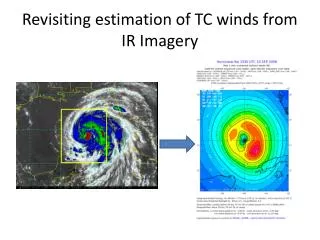
IR Data • Sensor ADS40 • Multi Band (NIR,R,G,B) • 1m resolution • Collection occurred in late June - early July • 6-7 Strips flying N and S across Reservation • Problem with configuration of the sensor
ADS40 New Design SP9, SP12, SP17, SP19 Flight direction PAN FW CIR PAN BW +28.4° RGB +18° +16° +14° -14.2° 0°
Radiometric Correction Preparation • To assist in image acquisition Tribe has contracted Marshall and Associates to aid us in technical specification writing and methods for the project • Panels were laid out in each flight line overlap area to aid in radiometric collection
Data is available on line: gis.cdatribe-nsn.gov