Download
1 / 22
220 likes | 320 Views
Part 3. Distribution and Movement of Air. Chapter 9 Air Masses and Fronts. Introduction. Air masses are large volumes of air that contain uniform temperature and humidity characteristics Different air masses have different source regions

E N D
Part 3. Distribution and Movement of Air Chapter 9 Air Masses and Fronts
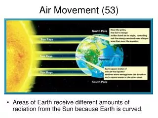
Introduction • Air masses are large volumes of air that contain uniform temperature and humidity characteristics • Different air masses have different source regions • Air mass properties can modify as the air mass travel over continents and oceans • Air mass properties will modify as the air mass moves north or south • Fronts are the boundaries between air masses
Continental Polar (cP) and Continental Arctic (cA) Air Masses • Canada and Asia origin for North America • Cold and dry • Inherently stable Continental Polar Air Arctic Air
cP Air Migration and Modification
Maritime Polar (mP) Air Masses • Upper latitude ocean origin • Cool and moist • Continental Tropical (cT) Air Masses • Desert southwest of U.S. and northern Mexico origin • Hot and very dry • Inherently unstable
Maritime Tropical (mT) Air Masses • Low latitude ocean origin (Gulf of Mexico) • Warm and moist • Inherently unstable
Weather map symbols that show the four types of fronts between air masses
Cold fronts • Cold air displaces warm air • Steep uplift of the warm air causes cumulonimbus clouds and precipitation Frontal development
A cold front depicted on a satellite picture (a) and radar composite (b)
Warm fronts • Warm air overruns and displaces colder air • Lifting along a warm front usually produces stratus clouds and often light precipitation • Stationary fronts • Neither air mass on either side of the front can make the front move very much • The warmer air can move aloft over the colder air at a stationary front
Occluded fronts form when a cold front overtakes a warm front. The front at the surface divides two cold air masses, while the warm air is aloft over the front. • Cold-type occlusion has a colder air mass pushing out a cooler air mass • Common in the eastern half of North America • Warm-type occlusion has a cooler air mass pushing out a colder air mass • Common along the western edge of North America
Some occlusions form when the surface low elongates and moves away from the junction of the cold and warm fronts
Some occlusions form when the intersection of the cold and warm fronts slides along the warm front
Drylines are fronts with little temperature change but a strong humidity contrast • Often form when cT air moves into mT air Continental Tropical Air Maritime Tropical Air