Download
1 / 37
390 likes | 607 Views
Introduction to ArcInfo (Workstation). Getting started with ArcInfo. ArcInfo subsystems. ArcInfo data types. Supported formats. The coverage. Basic unit for vector data Can be point, line, polygon Or region. Linking features and attributes.

E N D
ArcInfo data types • Supported formats
The coverage • Basic unit for vector data • Can be point, line, polygon • Or region
Linking features and attributes • Because every feature has a unique identifier, the uniqueness of each feature is guaranteed even if it shares attributes or spatial coordinates with another feature.
The workspace • A directory (folder) • Used in an ArcInfo session • Contains geo datasets and an INFO
Workspace commands • COPYWORKSPACE • CREATEWORKSPACE • DELETEWORKSPACE • LISTWORKSPACE • RENAMEWORKSPACE • WORKSPACE (or &WORKSPACE)
The geographic database • Core of a GIS • Completeness • Accuracy • Spatial data • Attribute data
Operating ArcInfo • Arctools (buttons+menus) • Limited to functions included • Command-driven interface • Customized/automated by AML • Open Development Environment (ODE) • Visual Basics, C, C++, Delphi, Power Builder
ArcInfo Commands Syntax rules
ArcInfo command example Arc: USAGE CLEAN Usage: CLEAN <in_cover> {out_cover} {dangle_length} {fuzzy_tolerance}{POLY|LINE} Arc: CLEAN STREET STREET2 # # LINE
Getting help for ArcInfo • Get Usage by typing the command • No argument • Good habit to do that Arc: BUILD Usage: BUILD <cover> {POLY|LINE|POINT|NODE|ANNO.subclass} Arc: COMMANDS ….. Arc: COMMANDS B BATCH BUFFER BUILD
ARC Macro Language (AML) • Use to communicate with the ARC system • Full programming capabilities • ArcInfo commands + OS commands • AML elements: • Directives • Functions • Variables
AML directives • Instruct AML to perform a specific operation • Start with an ampersand (&) • Examples: • Arc: &RUN my.aml • Executes an AML program • Arc: &MENU my.menu • Opens an AML menu • Arc: &TERM 9999 • Sets the terminal type for AML menus
AML functions • A function performs text substitution • The function name appears in [] • A function can return • A number • A character string • A Boolean value • Returned value can be used further Arc: BUILD [response ‘Enter the coverage to BUILD’] POLY Arc: BUILD [getcov * -line]
AML Variables • A way to store dynamic information • Variable types: • Character strings • Integers • Real numbers • Boolean expressions • &SETVAR – to set a variable’s value • Examples: Arc: &SETVAR COV = LANDUSE Arc: &SV COV [response ‘enter cov name:’] Arc: BUILD %COV% POLY
Summary • Subsystems • Data formats: raster and vector • ArcInfo workspace, INFO directory • Commands, ArcTools • AML: • directives, • functions, • Variables • ArcDoc and Command Usage
Topology • A mathematical procedure that determines these for geographic features • Spatial properties • Spatial relationships
Topology-Spatial Property ArcInfo uses the inherent topologic relationships of lines and polygons to provide extensive geographic analysis capabilities.
Coverage features • Coverages are either points, lines, or polygons • A coverage can be both a line coverage and a polygon coverage • Annotation • Descriptive text associated with other geographic features • E.g. street names, soil types
Feature attribute tables • FATs are INFO files • Each object is associated with a record in an FAT • A coverage may have more than one FAT (e.g. a PAT, AAT, & NAT)
Records and feature identifiers • RECNO – internal record number • COVER# - ArcInfo assigned ID • COVER-ID – user assigned ID
Routes • A coverage can contain multiple route systems • Each is a separate subclass • Each is made up of sections • Each section is made up of arcs or portions of arcs
Route events Events are located using the route’s measure units and the route contains sections that are associated to the arcs which contain the actual coordinate information.
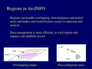
Regions Regions contain attribute information but do not contain spatial or coordinate information. Spatial information is determined from the underlying polygons that make up the region.
Annotation Is a feature type Does not represent geography of a feature Can be associated with other existing feature types Or as independent of any feature
Summary • Topology in ArcInfo coverage • Nodes, • points, • lines, • polygons, • regions, • subclasses
Exercises • Ex1 – Understanding spatial relationships • Ex2 – Introduction to GIS functions • Ex3 - Use the ArcInfo help system • Ex4 - Operate ArcInfo (commands, AML) • Ex5 - Operate ArcInfo (ArcTools)


![A Presentation to [Customer name]](https://cdn3.slideserve.com/6564618/a-presentation-to-customer-name-dt.jpg)