Download
1 / 40
460 likes | 764 Views
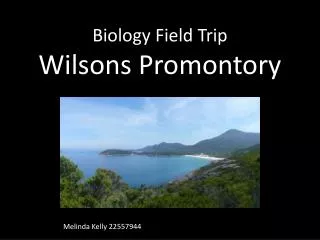
Wilsons Promontory South Gippsland Victoria . Core units: Exemplars – Year 8 Illustration 1: Landscape and landforms of Wilsons Promontory. Wilsons Promontory Lighthouse. History. European settlers followed the explorers into the South Gippsland region in the 1870s

E N D
Wilsons Promontory South Gippsland Victoria Core units: Exemplars – Year 8 Illustration 1: Landscape and landforms of Wilsons Promontory
History • European settlers followed the explorers into the South Gippsland region in the 1870s • The Promontory was named after a London friend of Matthew Flinders and originates from the voyage of George Bass and Matthew Flinders along the Promontory coast in 1798 • The first 'reservation' of Wilsons Promontory was proclaimed by the Victorian Government in 1898 • Today, Victorians call it 'The Prom'
Wilsons Promontory National Park The park is located at the southernmost point of the Australian mainland and is more than 50,000 hectares in area
Wilsons Promontory National Park Source of map: Parks Victoria
Wilsons Promontory National Park • It has 130 km of coastline and features granite headlands, mountains, forests and fern gullies • Tidal River, 30 km inside the park boundary, is the focus for tourism and recreation and has more than 400,000 visitors a year • The park contains the largest coastal wilderness area in Victoria
Geomorphology of 'The Prom' • The rock that makes up the landforms of the Promontory developed deep below the surface of the earth some 400 million years ago • Molten material cooled slowly and crystallised to form granite. • In time, the softer surface layers eroded leaving the mountains of granite you see today • During past ice ages, the oceans subsided and a range of granite mountains stretched across low-lying plains between the present day states of Victoria and Tasmania
Wilsons Promontory National Park • This photograph was taken in the northern section of the park (the largest wilderness area) from the Vereker Outlook, looking north • Corner Inlet is at the right of the photograph and Yanakie Isthmus to the left of the photograph
Wilsons Promontory supports a significant diversity of coastal vegetation
Wilsons Promontory supports a significant diversity of plants and animals • There are: • more than 700 native plant species • 30 kinds of mammals(marsupial mice, bats, kangaroos, koalas, seals, wallabies, wombats) • about 180 species of birds
Wilsons Promontory National Park Fire damage caused by recent bushfires, 10th February 2009 at 11pm
Norman Bay from Mount Oberon (558 metres) Norman Bay and Tidal River estuary (left) Leonard Bay and Leonard Point (middle distance) Norman Island off Leonard Point
Further reading Kettelsm, R. (2010). Southern star. Australian Geographic, 97, January–March, pp. 52–61. Ingamells, P. (1999). Discovering the Prom.Victorian National Parks Association, Melbourne. Meagher. D., & Kohout, M. (200). A field guide to Wilsons Promontory. Oxford University Press, Melbourne, 2002. Neilson, D. (1996). Wilsons Promontory: Coastal wilderness. Melbourne: SnowgumPress, Melbourne. Westcott, G. (1995). Wilsons Promontory: Marine and National Park, Victoria. Sydney: UNSW Press. Websites: Parks Victoria,http://www.parkweb.vic.gov.au Tourism Australia, http://www.australia.com/itineraries/vic_wilsons_prom.aspx Photograph source: All photographs provided by Roger Smith (author).