Download
1 / 11

E N D
Topographic Survey • Topography - defined as theshape or configuration orrelief or three–dimensionalquality of a surface • Topography maps are veryuseful for engineers whenplanning and locating astructure
Topographic Survey Introduction U.S. Geological Survey (USGS) has developed maps for a large part of the US Napoleon Bonaparte received his first promotion because of ability to make and use maps
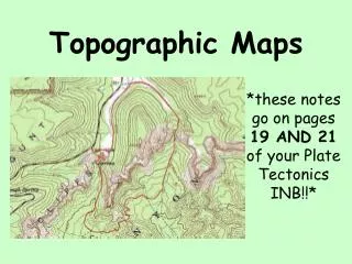
Topographic Survey Contours The most common method of representing the topography of an area is to use contour lines A contour line is an imaginary level line that connects points of equal elevation
Topographic Survey There are several rules to note when viewing topographic maps: The rule of Vs: sharp-pointed V usually are in stream valleys, with the drainage channel passing through the point of the V, with the V pointing upstream. The rule of Os: closed loops are normally uphill on the inside and downhill on the outside, and the innermost loop is the highest area. Spacing of contours: close contours indicate a steep slope; distant contours a shallow slope. Two or more contour lines merging indicates a cliff.
Contours Contours that point up hill can indicate a valley or stream
Contours Imagine a hill that has its top sliced off with a really big knife
Contours When is the steepest part of this terrain? The shallowest part?
Topographic Survey The selection of the contour is important The contour interval should be small enough to give the desired topographic detail while remaining economic Usually every fifth contour line is shown in a heavy, wider line, this is called a index line
Relief The relief is the distance between the highest point and lowest point of elevation on the map. A mapmaker chooses the contour interval based on the relief. A smaller interval may be used on a flat map whereas an interval of 100 feet may be used on steep mountainous terrain.
Reading a Topographic Map • Topographic maps, like other maps, use symbols to represent part of the Earth’s surface. • Different colors are also used to determine different parts of the Earth’s surface: • Buildings, roads, railroads and bridges are black. • Contour lines are brown. • Major highways red. • Cities and towns are pink. • Bodies of water such as lakes, rivers, ponds and oceans are blue. • Wooded areas are represented by the color green
Contour Lines: The Golden Rules • The following four rules can help you interpret the sizes and shapes of landforms on a topographic map. • 1. Contour lines never cross. • 2. The spacing of contour lines depends on slope characteristics. • 3. Contour lines that cross a valley or stream are V-shaped. • 4. Contour lines form closed circles around the tops of hills, mountains, and depressions.