Download
1 / 24
240 likes | 251 Views
Super Cells. The Granddaddy of them all. Textbook Definition Of A Supercell. A thunderstorm with a deep persistent mesocyclone (rotating updraft). Creating a Rotating Updraft. Directional Shear. Speed Shear. Updraft. What Makes Supercells So Unique?.

E N D
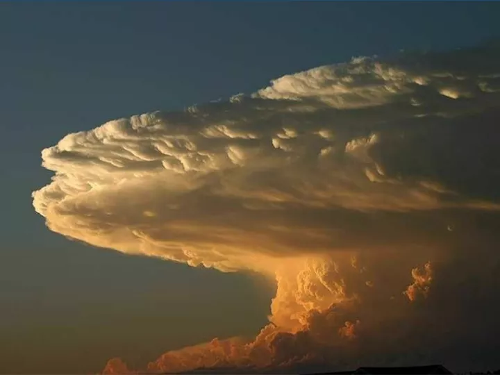
Super Cells The Granddaddy of them all
Textbook Definition Of A Supercell A thunderstorm with a deep persistent mesocyclone (rotating updraft)
Creating a Rotating Updraft Directional Shear Speed Shear Updraft
What Makes Supercells So Unique? • Rotation significantly enhances the vertical velocity of the updraft. • Updrafts become stronger (show more intense upward motion) and are more persistent after they begin to rotate. • Stronger updrafts transport more water and ice mass upward, potentially leading to larger hailstones, strong, damaging downdrafts and tornadoes. • About 90% of supercells produce severe weather • About 15% of supercells produce a tornado
Thunderstorm Structure
Updrafts And Downdrafts • Supercell strength depends on the intensity of the updrafts and downdrafts motion Strong Updrafts And Strong Downdrafts Lead to active weather Rain Free Base Primary “Action Area”
Supercell Updrafts • “back side” of storm • Towering clouds • Rain free base • Upward cloud motion
Supercell Downdrafts • “Front side” of storm • Dark area of storm • Rainfall region • Downward motion • Rain/Hail threat
Real World Example Looking NW ANVIL MAMMATUS UPDRAFT TOWER DOWNDRAFT Hail & Rain FLANKING LINE “ACTION AREA”
Rear Flank Down Draft Strong Downward Winds – sometimes cause dust whirls Form “clear slot” often in the shape of a horseshoe
From A Spotters Perspective Heavy Rain and Hail Mesocyclone Wall Cloud Wrapped in Rain RFD
Pop Quiz! ? ? ? Rain Free Base Wall Cloud / Updraft Area ? Downdraft Area Hail & Rain Tornado
The Ideal Spotter Position View from the north obscured by rain and hail. Radar image of a tornadic storm. Bird’s-Eye View Where should a spotter be positioned? Possible tornado at tip of “hook echo”.
The Ideal Spotter Position If you’re lucky, you might see this – but you need to be very close View from southwest obscured by hook and strong RFD winds.
The Ideal Spotter Position View from southeast offers unobstructed and safe look at the storm as it moves left to right.
In General, For Proper Positioning • You need to be able to see the updraft area of the storm • This is the action area • Severe weather most likely here • Find the updraft region • SQUALL LINE – leading edge (worst first) • SUPERCELL – back edge (worst last)
What You Might See:Wall Cloud • Isolated lowering of the cloud base • Attached to the cloud base • May or may not rotate • May see upward cloud motions • May slope down toward the rain area • Always Follows the Rain
More On Wall Clouds • Many storms produce wall clouds • Most do NOT produce tornados • Key: Identify dangerous wall clouds • Watch all clouds for danger signs • Report and monitor DOWNDRAFT Rain Rain INFLOW
Dangerous Wall Clouds • Look for… • …organized, sustained and persistent rotation • …clouds moving inward and upward • …strong surface inflow
Wall Clouds Shelf Clouds • Abrupt or “blocky” lowering • Linear feature • Associated with storm’s inflow • Associated with storm’s outflow • Sometimes has a tail that points to the precipitation • Slope away from precipitation • Move along with the rain area • Separate from the rain area • Never produce tornadoes • Sometimes produce tornadoes
Rain “Foot” Gives appearance of a foot Indicates strong winds • Results from strong downward winds • Rain slams into ground and spreads outwards
Funnel Clouds A rotating, funnel-shaped cloud extending downward from a thunderstorm base.
Funnel Clouds • Usually located near the updraft & within or along the edge of the wall cloud • Attached to cloud base • Exhibit rapid rotation • Often laminar or smooth in appearance • Circulation does not reach ground