Download
1 / 24
240 likes | 449 Views
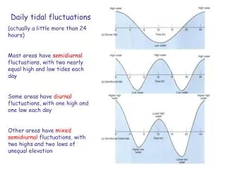
Daily tidal fluctuations (actually a little more than 24 hours) Most areas have semidiurnal fluctuations, with two nearly equal high and low tides each day Some areas have diurnal fluctuations, with one high and one low each day

E N D
Daily tidal fluctuations (actually a little more than 24 hours) Most areas have semidiurnal fluctuations, with two nearly equal high and low tides each day Some areas have diurnal fluctuations, with one high and one low each day Other areas have mixed semidiurnal fluctuations, with two highs and two lows of unequal elevation
Cause of Tides Gravitational attraction of moon/sun creates bulge of ocean water Centrifugal force creates second bulge Earth rotates through both bulges in ~24 hours, causing two high and two low tides each day
Monthly fluctuations in tides Over ~28 days, orientation of moon and sun changes with respect to Earth This causes two periods of large tidal range (spring tides) and two periods of small tidal range (neap tides) each month
Why we have monthly changes in tides Gravitational attraction from moon and sun pull water toward them This creates two bulges As the Earth rotates through these bulges each day, locations experience changing sea level Over a ~28-day period, the orientation of the moon and sun change, creating different tidal ranges through month Spring tide = large differences Neap tide = small differences
Tidal range (vertical difference between high and low tide) Macro > 4 m Meso = 2-4 m Micro <2 m Local differences in geometry of seabed can increase or decrease tidal range
Lagoonal environments Intertidal environments (between high and low tide) surround lagoon They trap and accumulate sediment, filling lagoon
Tidal-flat sedimentation Mud transported as suspended load accumulates on high flat Sand transported as bedload accumulates on low flat Upward growth ultimately controlled by rate of sea-level rise
Asymmetry between flood and ebb currents Frictional interaction with seabed commonly causes flood current to be stronger This results in more sediment being transported into the lagoon and onto the tidal flats, enhancing accumulation
Marsh vegetation Many niches develop, depending on many variables, e.g.,: salt and soaking tolerance, and current velocity Vegetation helps to baffle flow, reduce tidal current velocity, and enhance sediment accumulation
Mangrove distribution Found in warm, tropical settings Ocean circulation extends latitudinal distribution on west sides of ocean basins, and reduces distribution on east sides
Sediment Budget for Beaches and Coasts Sediment Sources: Longshore drift (local source) Cliff erosion Rivers Biogenic shells Continental shelf Sediment Losses: Dunes Lagoon (washover, tidal inlets) Submarine canyons (unusual) Longshore drift (local sink)
Prograding shoreline, building seaward Requires sediment supply to exceed processes leading toward landward movement of shoreline. Rivers are most common supply mechanism (example from east Texas coastline, downstream of Mississippi supply)
Impact of Groins to Shoreline Deposit sediment on upcurrent side, erode beach on downcurrent side Deflects longshore transport farther offshore
Jetty entrapment of sediment Sediment trapped on upstream side, due to longshore transport Loss of sediment causes erosion on downstream side, to resupply longshore transport system Similar to entrapment associated with groins, but on larger scale
Human Beach Structures groins