Download
1 / 28
300 likes | 578 Views
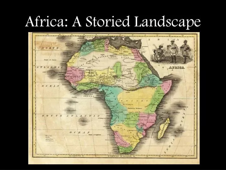
Africa: A Storied Landscape. Africa : A Storied Landscape Lesson prepared by Amy Perkins Lakeshore Public Schools www.yourhistoryhub.weebly.com Lesson prepared for Michigan Geographic Alliance. Lesson Overview.

E N D
Africa: A Storied Landscape Lesson prepared by Amy Perkins Lakeshore Public Schools www.yourhistoryhub.weebly.com Lesson prepared for Michigan Geographic Alliance
Lesson Overview Throughout this lesson students will examine the diverse climates and landscapes of Africa, carefully considering how the continent’s natural diversity shapes human-environment interaction.
Africa: A Storied Landscape Compliance with State Standards K-8 Content Expectationshttp://michigan.gov/documents/mde/SSGLCE_218368_7.pdf 6 – G1.2.3 Use data to create thematic maps and graphs showing patterns of population, physical terrain, rainfall, and vegetation, analyze the patterns and then propose two generalizations about the location and density of the population. 6 – G1.2.4 Use observations from air photos, photographs (print and CD), films (VCR and DVD) as the basis for answering geographic questions about the human and physical characteristics of places and regions. 6 – G1.3.1 Use the fundamental themes of geography (location, place, human environment interaction, movement, region) to describe regions or places on earth. 6 – G2.1.1 Describe the landform features and the climate of the region (within the Western or Eastern Hemispheres) under study. 6 – G4.4.1 Identify factors that contribute to conflict and cooperation between and among cultural groups (control/use of natural resources, power, wealth, and cultural diversity). 6 – G5.1.1 Describe the environmental effects of human action on the atmosphere (air), biosphere (people, animals, and plants), lithosphere (soil), and hydrosphere (water) 7 – G1.1.1 Explain and use a variety of maps, globes, and web based geography technology to study the world, including global, interregional, regional, and local scales.
Goals • To enhance students’ understanding of Africa’s diverse landscapes and climates • To improve students’ ability to read and interpret maps • To challenge students to identify various forms of human-environment interaction in Africa • To empower students to think critically, employing their skills to reach conclusions about the dynamic relationship between humans and their environment
Africa: A Storied Landscape Objectives: Students will be able to… • Identify different geographic regions and major physical features located in Africa • Describe how various climates, the availability of natural resources, and topography affect human experience • Detail both positive and negative consequences of human- environment interaction
Africa: An Introduction to the Storied Landscape Study each of the following images and attempt to answer these questions: • What is it? • Where is it? • How does the image testify to human-environment interaction in Africa?
Fishing traps made out of mangroves in the Greater St. Lucia Wetlands area in South Africa
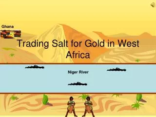
Salt pans in northwestern Niger. Aerial photograph of man-made salt pans in the western Sahara desert. These shallow pools are filled with salt water from underground springs. The water is left to evaporate leaving a crust of salt that is then mixed with soil. The soil contains minerals and bacteria that enrich the salt and produce the various colors seen here. The mixture is then left to dry to allow the salt to crystallize. This enrichment process may be repeated several times. The final product is sold as an animal feed supplement.
Sources • http://www.sciencephoto.com/ • http://ngm.nationalgeographic.com/ngm/megaflyover/gallery6.html
Let’s take a closer look at Africa’s diverse landscapes and climates and consider the following questions: • How does this diversity shape the economies, cultures, and politics of various regions? • What are the positive and negative consequences of human-environment interaction in Africa?
Africa: A Storied Landscape • Unfold your map of Africa and study the side entitled, “Africa: A Storied Landscape.” • Within your small groups, briefly study the map and identify the following… -important physical features of Africa -major climate regions of Africa • Locate the key detailing Africa’s climates (along the right margin of the map) and carefully cut this key from the map. Be sure to include all of the descriptive text boxes. • Align the key along the center of the African continent from north to south.
Observations: • What are the relative locations of Africa’s major climate regions? • Locate the “crowded spaces” in Africa. Why are these places more densely populated than other regions of Africa? Predictions: • What are some environmental challenges/benefits people might face in various regions of Africa? • How will Africa’s natural diversity impact regional economies, political stability, and cultural traditions?
Human Environment Interaction in Africa Humans have a dynamic relationship with their natural environment. Identify some ways in which humans … • depend on the environment for their basic needs of food, shelter, and clothing • adapt to survive the environment’s climate, topography, and natural hazards • modifythe environment to meet their changing needs using technology
Human-Environment Interactionin Africa Use both sides of your map to complete the charts of Human-Environment Interaction in Africa.
The people of the Atlas Mtns depend on springs for water. The people adapt to the land by having towns tap the springs for pure water. The people modify their land by diverting springs for irrigation for their farms. The people of Ethiopia modify the land by clearing the land through controlled fires. The people depend on the Nile River for water. The people adapt to the land by living on farms. The people of the West Zambezi Floodplain depend on their land for food. The people adapt by moving livestock during floods. The people modify their land by building their villages on high mounds. In Egypt, the government pumps water west to create new lakes and irrigate farmland in desert. North Africans depend on narrow fertile strip of land near Mediterranean and Nile River for farming. North Africans use their land for farming.
The people of West Africa depend on trees for their homes and food. The people modify their land by planting oil palms and mangoes. The people adapt to their land by producing firebreaks during the savanna fires. The people modify the land by clearing the land through fires. The people adapt to the land by living on farms The people of Ethiopia depend on the land for food. People in the Congo Basin depend on the forests for food, water, shelter, & fuel. The loggers &miners modify the Congo Basin by building roads for hunters and farmers to use The loggers and miners adapt to the forests by moving their operations deeper into the forest.
People modify their land by building terraces on hills for their crops. People of Rwanda depend on their land for big harvest of food. People adapt to their land by planting crops on steep slopes. The people of Nigeria adapt to the land by feeding their livestock weeds and using manure for fertilizer. The people of Nigeria modify their land by using ox-drawn plows to turn soil. The people of Nigeria depend on the land for their food. Corn is sensitive to drought, sometimes leading to food shortages Scientists are developing drought-resistant corn species. Malawi farmers depend on corn for food source. Ethiopians live in the highlands, a region known for its fertile soil and an area with fewer cases of malaria due to elevation. Ethiopians are over-farming, depleting fragile soil of its nutrients at an unsustainable rate. Farm yields are falling despite rapid population increase. People depend on fertile soil to provide food.
Questions to Consider • Are there any general patterns you notice as you review your charts? • What are some possible long-term consequences for human-environment interaction in Africa? • How might the natural environment affect the economies and political stability of the continent’s various regions?
Extensions: Geography and Recent Events • Sudan (Darfur) • Rwanda (1994 Genocide) • Somalia (global relief effort) • South Africa (apartheid) • Other ideas?
Online Resources: Africa • NGS site for “Africa: A Storied Landscape” http://ngm.nationalgeographic.com/ngm/0509/feature1/zoomify/index.html • PBS site for lessons on Africa http://www.pbs.org/wnet/africa/tools/lesson_plans.html • BBC “Story of Africa” http://www.bbc.co.uk/worldservice/africa/features/storyofafrica/ • Interactive map of Africa (craft your own one page map) http://education.nationalgeographic.com/education/mapping/outline-map/?ar_a=1 • Africa’s struggle with AIDS (lesson online) http://www.nationalgeographic.com/xpeditions/lessons/01/g68/africaaids68.html • Human Impact on Africa as seen from plane (lesson online) http://www.nationalgeographic.com/xpeditions/lessons/01/g68/africaplane.html • Ancient Africa: migration patters and spread of Islam (lesson online) http://edsitement.neh.gov/lesson-plan/lesson-2-trekking-timbuktu-trade-ancient-west-africa-teacher-version • Human Impact on Ancient Rainforests: What we can do http://www.nationalgeographic.com/xpeditions/lessons/14/g912/fayhuman.html • Thinkfinityhttp://thinkfinity.org/welcome