Download
1 / 24
240 likes | 388 Views
SPC Convective Outlook Changes. Changes in Category Names/Definitions. Bill Sammler Warning Coordination Meteorologist National Weather Service, Wakefield VA http://weather.gov/akq. Storm Prediction Center ( SPC ). Located in Norman, OK since 1997

E N D
SPC Convective Outlook Changes Changes in Category Names/Definitions Bill Sammler Warning Coordination Meteorologist National Weather Service, Wakefield VA http://weather.gov/akq
Storm Prediction Center (SPC) • Located in Norman, OK since 1997 • Issues Outlooks for Thunderstorms/Severe Thunderstorms and Fire Weather • Issues All Tornado and Severe TstmWATCHES nationwide
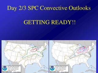
Current SPC Outlooks • 3 Tiers - SLGT, MDT and HIGH • “See Text” Used for Marginal Situations • Increased Coverage and Higher Intensity with MDT/HIGH
Rationale for Proposed Changes • Limitations of SEE TEXT and SLGT • SLGT, MDT, HIGH have been used for 40 years and have some established understanding. Breakpoint thresholds for these categories remain essentially unchanged • Addition of ENH addresses concern about SLGT(word meaning and probabilistic range) • Numbers/colors on legend will further aid interpretation • Social science informed SPC discussions on the change
Day 1-3 Outlook Changes • Increase risk categories to 5 levels for Day 1, Day 2, & Day 3 Outlooks Category 1 = MRGL Category 2 = SLGT Category 3 = ENH Category 4 = MDT Category 5 = HIGH SPC Severe Weather Outlook Probability-to-Categorical Description Tables (2014) ENHANCED TSTMS SLGT MDT HIGH MARGINAL SLGT HIGH ENHANCED MARGINAL MDT TSTMS MARGINAL ENHANCED SLGT MDT TSTMS MARGINAL HIGH MDT ENHANCED TSTMS SLGT “sig” = Significant Severe Tstms = Hail 2+ and/or Wind ≥ 65KT/75 MPH TSTMS ENHANCED MDT MARGINAL SLGT SLGT ENHANCED
Day 1-3 Outlook Changes • Increase risk categories to 5 levels for Day 1, Day 2, & Day 3 Outlooks • Replace See Textwith Marginal for lowest risk probabilities (Day 1 - Day 3) SPC Severe Weather Outlook Probability-to-Categorical Description Tables (2014) ENHANCED TSTMS SLGT MDT HIGH MARGINAL SLGT HIGH ENHANCED MARGINAL MDT TSTMS MARGINAL ENHANCED SLGT MDT TSTMS MARGINAL HIGH MDT ENHANCED TSTMS SLGT “sig” = Significant Severe Tstms = Hail 2+ and/or Wind ≥ 65KT/75 MPH TSTMS ENHANCED MDT MARGINAL SLGT SLGT ENHANCED
Day 1-3 Outlook Changes • Increase risk categories to 5 levels for Day 1, Day 2, & Day 3 Outlooks • Replace See Textwith Marginal for lowest risk probabilities (Day 1 - Day 3) • Insert Enhanced between high-end SLGT & low-end MDT probabilities SPC Severe Weather Outlook Probability-to-Categorical Description Tables (2014) ENHANCED TSTMS SLGT MDT HIGH MARGINAL SLGT HIGH ENHANCED MARGINAL MDT TSTMS MARGINAL ENHANCED SLGT MDT TSTMS MARGINAL HIGH MDT ENHANCED TSTMS SLGT “sig” = Significant Severe Tstms = Hail 2+ and/or Wind ≥ 65KT/75 MPH TSTMS ENHANCED MDT MARGINAL SLGT SLGT ENHANCED
Day 4-8 Outlook Changes • Increase risk categories to 5 levels for Day 1, Day 2, & Day 3 Outlooks • Replace See Textwith Marginal for lowest risk probabilities (Day 1 - Day 3) • Insert Enhanced between high-end Slight & low-end Moderate probabilities • Add a 15 percent (Slight Risk) to Day 4-8 Outlooks SPC Severe Weather Outlook Probability-to-Categorical Description Tables (2014) ENHANCED TSTMS SLGT MDT HIGH MARGINAL SLGT HIGH ENHANCED MARGINAL MDT TSTMS MARGINAL ENHANCED SLGT MDT TSTMS MARGINAL HIGH MDT ENHANCED TSTMS SLGT TSTMS ENHANCED MDT MARGINAL SLGT Expected to result in better alignment with WFO forecasts and DSS SLGT ENHANCED
Example of Change (Day 1) 13Z Day 1 (New) 6/1/2011 13Z Day 1 LSRs 6/1/2011 13Z Day 1 (Current) 6/1/2011
Current Timeline for Implementing Changes: September 2014 SPC Outlook Changes
Impact Based Warning Experimental Product
Impact Based Warning Experimental Product • Spring 2014 Expansion • IBW began in 2012. • Positive feedback supported expansion to 38 central region offices in 2013. • In 2014, six new offices, including NWS Blacksburg, were added. • Expansion is expected in the future.
Impact Based Warning Experimental Product • Goals: • Provide additional valuable information to media and Emergency Managers • Facilitate improved public response and decision making • Better meet societal needs in the most life-threatening weather events
Impact Based Warning Experimental Product • Intended Outcomes: • Optimize the convective warning system within the existing structure • Motivate proper response to warnings by distinguishing situational urgency • Realign the warning message in terms of societal impacts • Communicate recommended actions/precautions more concisely • Evaluate ability to distinguish between low impact and high impact events 2011 Raleigh EF3 Tornado?
Impact Based Warning Experimental Product
Impact Based Warning Examples Tornado – Radar Indicated or Observed
Impact Based Warning Examples Tornado – Tag: Considerable
Impact Based Warning Examples Tornado – Tag: Catastrophic
Impact Based Warning Examples Severe Thunderstorm Warning: Tornado Possible
Impact Based Warning Experimental Product • Enhancements By: • Improving communication of critical information • Making it easier to quickly identify the most valuable information • Enabling users to prioritize the key warnings in your area of interest • Providing different levels of risk within the same product • Enabling the NWS to express a confidence level of potential impacts
Impact Based Warning Experimental Product • Evaluation: • Performed by social science research groups and National Weather Service • Using focus groups and surveys • Media partners • Emergency Management • Public • NWS Forecasters
Impact Based Warning Experimental Product http://www.weather.gov/survey/nws-survey.php?code=IBW www.weather.gov/impacts
The End!! Are There Any Additional Questions? william.sammler@noaa.gov phil.hysell@noaa.gov