Download
1 / 18

E N D
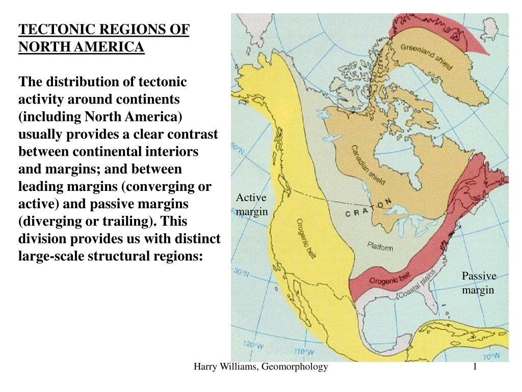
TECTONIC REGIONS OF NORTH AMERICA The distribution of tectonic activity around continents (including North America) usually provides a clear contrast between continental interiors and margins; and between leading margins (converging or active) and passive margins (diverging or trailing). This division provides us with distinct large-scale structural regions: Activemargin Passive margin Harry Williams, Geomorphology
Craton: old, Precambrian (540 million+) metamorphic and igneous rocks at the "core" of continents. The metamorphic rocks are the "roots" of ancient orogenic belts, long since eroded away. Shield: the exposed part of the craton. The North American craton is exposed mainly in the Canadian Shield. Platform: adjacent to the shield, this is where the craton is covered by newer sedimentary rocks. Cratonic rocks are also called "basement rocks" because they underlie more recent rocks in Platform regions. Orogenic belts - the currently or formerly active edge of continents, severely deformed due to tectonic activity(orogenic = "mountain-building"). Passive margins - the trailing edge of continents; little or no tectonic activity. Harry Williams, Geomorphology
The craton tends to be very stable, but has undergone broad warping in the past (because of tectonic movements around the margins) - especially in platform areas, creating basins, domes and tilted strata. View of the Canadian Shield Harry Williams, Geomorphology
Platform Regions. Harry Williams, Geomorphology
Deformed accretionary wedge sediments in california – a real contrast to mostly flat sedimentary strata in Platform areas such as Texas. Harry Williams, Geomorphology
Platforms Platforms occur where the craton is covered by relatively undeformed layers of sedimentary rock, formed when seas occupied these areas (due to tilting/sinking of the craton or rise in sea level – all driven mainly by tectonics). A large part of the interior of North America consists of platform areas. Structure within the platform rocks is usually quite subdued: however, many parts of platforms are not completely flat; instead broad warping of the underlying craton has produced gently tilted beds (< 5o), domes (e.g. the Black Hills of Dakota; Ozark Mountains of Missouri) and basins (e.g. Michigan Basin, Permian Basin). Harry Williams, Geomorphology
An exception to the generally subdued structure of platforms, resulting from plate movements, is intracratonic rifting which forms rift valleys, seas and aulacogens in platform regions. Red Sea rift(view to the south) Harry Williams, Geomorphology
A relatively new idea in plate tectonics suggests that rifting may actually be initiated by hot spots which cause the continental crust to dome up and split into a triple rift. Commonly, one of the rift arms fails, while the other two become active and contribute to an opening linear ocean basin. So the convection cell that drives sea-floor spreading may actually be a line of "hot spots". Harry Williams, Geomorphology
The rift valley forms a large linear trough, bounded by fault scarps and floored by volcanic rocks. If the valley extends below sea level, it becomes the site of sedimentation. Harry Williams, Geomorphology
The failed arm, represented by a deep linear trough into the adjacent continent, may become a natural location for a major river valley within platform areas - probable examples include the Mississippi and the Amazon. Harry Williams, Geomorphology
It is also possible for a failed arm of a rift to become "squeezed shut" by later plate movements - forming an aulacogen. The Arbuckle Mountains lie on the northeastern margin of the southern Oklahoma aulacogen. Closure of the aulacogen resulted in severe folding and faulting of marine sedimentary rocks which had accumulated in the trough - one of the few places that platform strata are so deformed. Harry Williams, Geomorphology
Recap: although platform rocks can be severely deformed like those in the Arbuckles, they are more usually flat or gently tilted, like these shown below in Dallas. Harry Williams, Geomorphology
Orogenic Belts In the case of North America there are two major orogenic belts - the older Appalachian chain in the east, and the much younger Cordilleran belt in the west. Both were formed by plate convergence and have similar structural features. Both areas underwent uplift, metamorphism, volcanism, folding, thrust faulting and later erosion; some crustal extension was also experienced in the west. SHIELD OROGENIC BELT OROGENIC BELT PLATFORM Appalachians ACTIVE MARGIN COASTAL PLAIN Cordillera PASSIVE MARGIN Ouachitas Harry Williams, Geomorphology
The present-day relief of these mountains is a result of erosion - the Appalachians being much older are more subdued and lower and consist mainly of eroded folds (more on this later). Appalachians Cordillera Harry Williams, Geomorphology
The western Cordillera has a number of other features related to orogenesis: Erosion has exposed the granitic batholiths emplaced during orogenesis, forming the Sierra Nevada Mountains. Half Dome Mountain Harry Williams, Geomorphology
Another part of the crust in the west underwent stretching during the orogeny - forming the Basin and Range Province. These ridges and valleys are formed by normal faulting caused by crustal stretching (more later). Death Valley Harry Williams, Geomorphology
Another large region in the west experienced uplift, but with little deformation, forming the large Colorado plateau - rivers cut down through the uplifted strata forming many canyons, including the Grand Canyon. Coloradoplateau Harry Williams, Geomorphology
The Atlantic and Gulf Coast margins of the U.S. are PASSIVE MARGINS, characterized by low-lying flat coastal plains extending below sea-level into a wide continental shelf (the submarine part of the continent, overlain by sediments and subject to subsidence - recall the role of these sediments in orogenesis). Harry Williams, Geomorphology