Download
1 / 17
170 likes | 267 Views
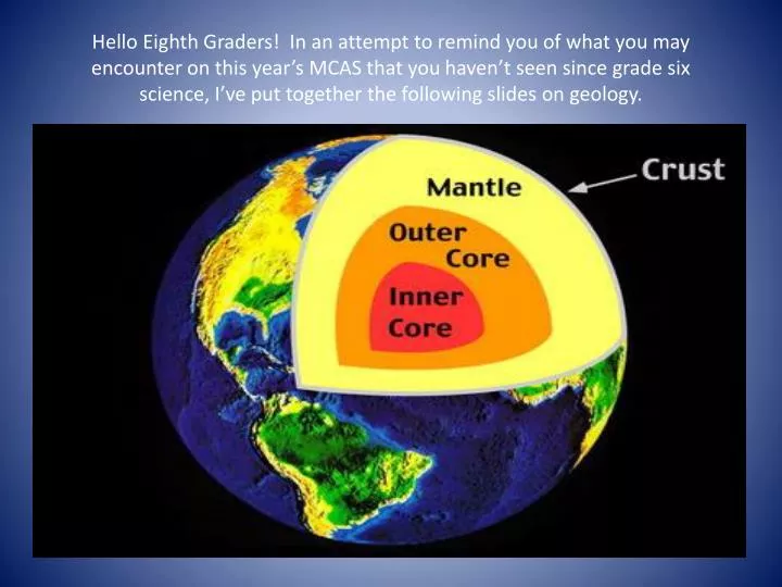
Hello Eighth Graders! In an attempt to remind you of what you may encounter on this year’s MCAS that you haven’t seen since grade six science, I’ve put together the following slides on geology. Try to answer the following questions related to the last slide.

E N D
Hello Eighth Graders! In an attempt to remind you of what you may encounter on this year’s MCAS that you haven’t seen since grade six science, I’ve put together the following slides on geology.
Try to answer the following questions related to the last slide. • Do you know which of the earth’s layers contains the most molten rock and do you know why the answer is a bit unexpected? • Do you know why the earth hasn’t completely cooled to the point where there is no molten rock? • Do you know how thick the crust is compared to the remainder of the earth? Answers are found on the next slide.
Answers • Interestingly, the outer core is mostly molten even though the inner core is likely to be quite a bit hotter. The added pressure on the inner core results in it remaining solid… a very hot solid! • Our moon and planet Mercury, as well, are now completely solid but each has a history of molten lava/magma and volcanic eruptions. Earth as well as other planets are larger so will take longer to cool. In addition, decay of radioactive elements adds a lot of heat to the earthly system. • The earth’s crust ranges from about 5 km to 50 km thick (thickest on mountainous continental masses and thinnest below oceans especially near mid ocean ridges) while earth’s diameter is about 12,000 km.
See if you can answer the following questions. • What do the red dots on the diagram represent and what is important about their location? • Notice two red dots near the center of the Pacific Plate called the ‘Hawaiian Hot Spot’. What is unusual about it’s location? • Find the Mid-Atlantic Ridge. It is know as a ‘spreading center’…a place where a crack in the mid-ocean floor that occasionally widens exists. The average rate of widening is about an inch per year. At that rate how long will it take the Atlantic ocean to widen by one mile? • Where might one find a collision zone and what happens there?
The spreading boundary illustrated below might be considered a good representation of how the Atlantic formed.
Answers • The red dots indicate the locations of active volcanoes. They are almost always found along tectonic plate boundaries. • The Hawaiian volcanoes are found in the center of a tectonic plate which is unusual but not unheard of. Geologists struggle to explain the reason for such mid-plate ‘hot spots’ but interestingly enough such a hot spot exists below ‘Old Faithful’ in Yellowstone Park, WY! • 1 inch/year X 12 inches/foot X 5280 feet/mile = 63,360 years But even that much motion wouldn’t be noticeable on a map…the earth changes very slowly but has been around long enough for huge changes to take place! • A Collision zone is found on the west coast of S. America which has given rise to the Andes Mt. range. Do you know what plates are colliding there?
I’d bet that many know what place this is…but do you know the name of the river responsible?
The Colorado River is responsible for the creation of the Grand Canyon. Well, partially responsible. • What type of rock makes up the walls of the Grand Canyon and what do I mean when I say that the Colorado river is “partially responsible”? • How old is the Grand Canyon?
Answers • The walls of the Grand Canyon are 99% sedimentary rock (or metamorphic rock that was previously sedimentary) like the sandstone pictured in the previous slide. I say ‘partially’ responsible for two reasons. First, the Colorado river couldn’t have eroded so deeply unless tectonic forces were forcing the plateau to rise meaning that part of the world was located near a plate collision. Secondly, the sedimentary rock had to be formed previously. • The age of the Grand Canyon is a tough question. The Colorado River has probably been eroding the canyon for several million years or so. But, the rocks at the bottom of the canyon are over a billion years old, in some cases, so the answer depends on your point of view. More info about the G C found via link below. • http://www.nps.gov/grca/naturescience/geologicformations.htm
Triassic period: Mesozoic era: Can geologists find evidence of the following in the Grand Canyon?
Probably not! Just like the dirt supporting the houses below is soon to be eroded away, much of the dirt/rock that was, long ago, part of the Grand Canyon rock formations, was eroded away. So as a result evidence from the Age of dinosaurs is mostly missing from GC rocks!
Take a look at a modern day event of rapid erosion. Some of you may know that the mudslide below is responsible for the destruction of hundreds of homes and 41 deaths. This occurred in Oso, Washington a month or so ago.
Of course, water is not the only erosive agent. Glaciers move a lot of rock and sediment, too. In fact, most of the rocks you find in your back yard were moved by glaciers!
Finally, our last topic! Topography/MapsYou may remember that each of the curvy lines are called contour lines but do you remember what contour interval means?Can you determine where a river might flow?
Of course, contour interval is the change in vertical elevation between consecutive contour lines. And since contours make a ‘V’ shape upstream the river would be flowing downhill towards the west. See how much information you can glean from the map below:
Topography wrap-up! • I notice that the contour interval on the map is 40 feet. Every fifth contour was labeled 200 feet higher/lower and 200/5 = 40 (it must be feet since meters would mean these mountains were as high as the Himalayas!). • There are very high mountains ( some nearly 10,000 feet tall on the southwest portion of the map) that trend from northwest to southeast and that border a valley in between that trends in the same direction. There are also some lakes or ponds and rivers/streams that are found in the valley (notice the contour lines near the rivers!) • I hope MCAS goes well for you. But, more importantly, good luck @LHS next year! Mr. Rogers