Download

1 / 24
310 likes | 518 Views
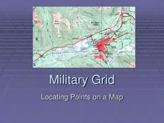
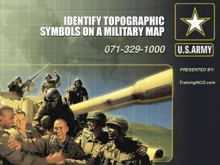
Determine the Grid Coordinates on a Military Map. 071-329-1002. PRESENTED BY:. TrainingNCO.com. CONDITIONS:. Given a standard 1:50,000-scale military map in a field location, a 1:50,000 grid coordinate scale, a pencil, paper, and a point on the map. STANDARDS:.

E N D
Determine the Grid Coordinates on a Military Map 071-329-1002 PRESENTED BY: TrainingNCO.com
CONDITIONS: • Given a standard 1:50,000-scale military map in a field location, a 1:50,000 grid coordinate scale, a pencil, paper, and a point on the map.
STANDARDS: • Determine the six-digit grid coordinates for the point on the map with a 100-meter tolerance. Record the grid coordinates with the correct two-letter 100,000-meter-square identifier.
NOTES: • A military map can help you spot your location accurately. The map has vertical lines (top to bottom) and horizontal lines (left to right). These lines form small squares 1,000 meters on each side called grid squares. • The lines that form grid squares are numbered along the outside edge of the map picture. No two grid squares will have the same number. • The precision of a point location is shown by the number of digits in the coordinates; the more digits, the more precise the location. For example, "1996" is a 1,000-meter grid square, that is, it identifies a location to the nearest 1,000 meters. "192961" is a 100-meter grid square, that is, it identifies the location to the nearest 100 meters.
PERFORMANCE STEPS Figure 1. Grid square 1181. • Look at Figure 1.
PERFORMANCE STEPS Figure 1. Grid square 1181. • Your address is grid square 1181. To determine your address, start from the left and read right until you come to 11, the first half of your address. Then read up to 81, the other half. Your address is somewhere in grid square 1181.
PERFORMANCE STEPS Figure 1. Grid square 1181. • Determine your address to the nearest 100 meters. Grid square 1181 gives your general neighborhood, but there is a lot of ground inside that grid square.
PERFORMANCE STEPS Figure 1. Grid square 1181. • To make your address more accurate, just add another number to the first half and another number to the other half so your address has six numbers instead of four.
PERFORMANCE STEPS Figure 1. Grid square 1181. • To get these extra numbers, suppose that each grid square has 10 lines inside it running north and south, and another 10 running east and west. This makes 100 smaller squares. You can estimate where these imaginary lines are ( Figure 2 ).
PERFORMANCE STEPS Figure 2. Grid square 1181 divided. • Suppose you are halfway between grid line 11 and grid line 12. Then the next number is 5 and the first half of your address is 115. Now suppose you are also 3/10 of the way between grid line 81 and grid line 82. Then the second half of your address is 813. Your address would be 115813 (Figure 2). (If you are exactly on line 81, the second half would be 810.)
PERFORMANCE STEPS • Use a coordinate scale. The most accurate way to determine the coordinates of a point on a map is with a coordinate scale. You need not imagine lines, because you can find the exact coordinates using the coordinate scale, protractor ( GTA 5-2-12, Figure 3 ), or the plotting scale ( Figure 4 ). Figure 3. Coordinate scale and protractor. • Each device actually includes two coordinate scales, 1:25,000 and 1:50,000 meters. Make sure that, regardless which device you use, you choose the correct scale. Figure 4. Plotting scale
PERFORMANCE STEPS Figure 5. Placement of the coordinate scale. • Locate the grid square where the point is located, for example, Point A ( Figure 5; this point should already be plotted on the map. )
PERFORMANCE STEPS Figure 5. Placement of the coordinate scale. • The number of the vertical grid line on the left (west) side of the grid square gives the first and second digits of the coordinate.
PERFORMANCE STEPS Figure 5. Placement of the coordinate scale. • The number of the horizontal grid line on the bottom (south) side of the grid square gives the fourth and fifth digits of the coordinate.
PERFORMANCE STEPS Figure 5. Placement of the coordinate scale. • Place a coordinate scale on the bottom horizontal grid line of the grid square containing Point A to determine the third and sixth digits of the coordinate.
PERFORMANCE STEPS Figure 5. Placement of the coordinate scale. • Check to see that the zeros of the coordinate scale are in the lower left-hand (southwest) corner of the grid square where Point A is located ( Figure 5 ).
PERFORMANCE STEPS • Slide the scale to the right, keeping the bottom of the scale on the bottom grid line until Point A is under the vertical (right-hand) scale ( Figures 6 and 7 ). To determine the six-digit coordinate, look at the 100-meter mark on the bottom scale, which is nearest the vertical grid line. Figure 6. Grid reference box. Figure 7. Aligning the plotting scale
PERFORMANCE STEPS Figure 6. Grid reference box. • This mark is the third digit of the number 115. The 100-meter mark on the vertical scale nearest to Point A gives you the sixth digit of the number 813. Putting these together, you have 115813. Figure 7. Aligning the plotting scale
PERFORMANCE STEPS Figure 8. Grid reference box • To determine the correct two-letter 100,000-meter-square identifier, look at the grid reference box in the margin of the map ( Figure 8 ).
PERFORMANCE STEPS Figure 8. Grid reference box • Place the 100,000-meter-square identifier in front of the coordinate, GL115813.
EVALUATION PREPARATION: • SETUP: Give the Soldier a standard 1:50,000-scale military map in a field location, a 1:50,000 grid coordinate scale, a pencil, paper, and a point on a map for which coordinates must be determined.
BRIEF SOLDIER: • Tell the Soldier to write down the two-letter 100,000-meter-square identifier and the six-digit grid coordinates for one point, along with the two-letter 100,000-meter-square identifier.
REFERENCES: • REQUIRED: FM 3-25.26 GTA 05-02-12
Determine the Grid Coordinates on a Military Map 071-329-1002 PRESENTED BY: TrainingNCO.com