Download
1 / 17
170 likes | 423 Views
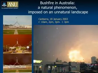
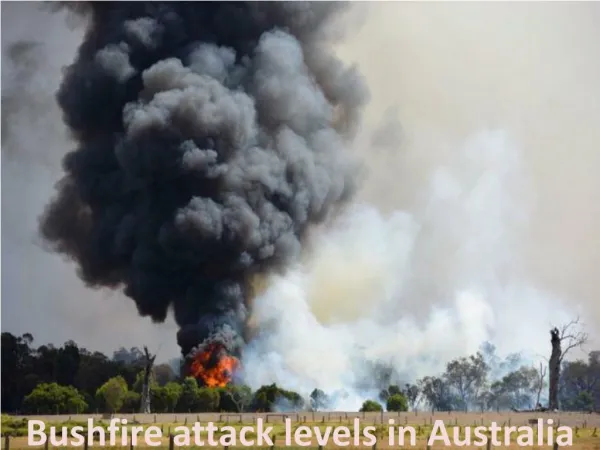
Summer Weather and Bushfire Threats in SE Australia. Tony Langdon VK3JED for the VoIP Weather Net November 5 2006. 1. Summer Weather and Bushfire Threats in SE Australia. Major Air Masses Around Australia in Summer. Typical Summer Weather Patterns in Australia.

E N D
Summer Weather and Bushfire Threats in SE Australia Tony Langdon VK3JED for the VoIP Weather Net November 5 2006 1
Summer Weather and Bushfire Threats in SE Australia • Major Air Masses Around Australia in Summer. • Typical Summer Weather Patterns in Australia. • Fire Danger in Southeastern Australia. • Fire Seasons Around Australia. • Weather Factors Influencing Fire Danger. • High Risk Fire Weather Patterns in SE Australia. • Effect of Cold Front on Fire Spread. • Example of High Risk Day - “Ash Wednesday”. • Prognosis for 2006/2007 and Recent Climate. 2
Major Air Masses around Australia in Summer • SE Australia is influenced by 3 major air masses during summer. • Hot, dry continental to the NW (Australia) • Extremely hot and dry – Often creates extreme fire danger. • Warm, moist maritime to the NE (N Tasman Sea and Pacific Ocean) • Warm to hot and humid conditions, may be a factor in severe storms. • Southern Maritime (Southern Ocean) • Cool, moist conditions – may cause drizzle showers. Cold fronts can cause dramatic temperature falls – as much as 20C in 20-30 minutes. 3
Major Air Masses around Australia in Summer Courtesy Recreational Aviation Australia Inc 4
Typical Summer Weather Patterns in Australia. Courtesy Australian Bureau of Meteorology 5
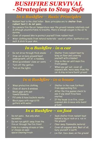
Fire Danger in Southeastern Australia • Vegetation includes a number of highly flammable species (e.g. Eucalypts and dry grasses). • Many species have evolved to recover quickly after fires, and some even depend on fire to reproduce. • Fire is a natural part of the Australian environment (though human activities have increased their frequency over the past 40,000 years) • Mild (by US standards) winters allow a long growth season. • Summer temperatures often exceed 35C (95F), often accompanied by low humidity (under 20%) and high winds (> 20 knots). • Strong, dry frontal changes can greatly increase the length of a fire front and drive the fire into unburnt fuel. • Fringe areas of major cities are the most vulnerable to fire damage, due to high population density extending into bushland. 6
Fire Seasons Around Australia • Courtesy Australian Bureau of Meteorology 7
Weather Factors InfluencingFire Danger • Humidity – Relative humidity < 20% causes fuel to dry out, making it more easily flammable. • Wind – High winds provide more oxygen to feed the fire and increase speed of spread. High winds can also pick up burning embers and carry them considerable distances to start new fires ahead of the main fire. This is known as “spotting”. • Drought – Causes heavier fuels to dry out, increasing the risk of a fire starting and more intense fires. 8
High Risk Fire Weather patterns in SE Australia • Drought, as occurring in 2006 greatly increases fire risk. • Northwesterly winds preceding a cold front bring hot, dry air from central Australia. These winds are often strong as well, due to tight pressure gradients near the front. • Cold front brings high winds and a sudden 90 degree change in direction, which causes flank of fire to become a broad front. 9
Effect of Cold Front on Fire Spread • Courtesy Australian Bureau of Meteorology 10
Example of High Risk Fire Day in SE Australia - “Ash Wednesday”February 16, 1983 • Courtesy Australian Bureau of Meteorology 11
Example of High Risk Fire Day in SE Australia - “Ash Wednesday”February 16, 1983 • Pre-frontal trough intensified northerly winds and brings hot, dry area from central Australia. Winds exceeded 30 knots for much of the day, temperature in Melbourne exceeded 43C (110F), with extremely low humidity. • Cold front and trough caused a wind change from NW to SW, causing fires to spread rapidly on large fronts. Wind increased to over 50 knots during the passage of the front. • Over 400,000 hectares (1 million acres or 1550 square miles) were burnt across 2 states. Reported rates of fire spread exceeded 60mph at some stages. 12
Prognosis for 2006/2007 • Persistent below average rainfall (10 years), culminating in a severe drought means fuel will be dry. • Current El Nino conditions make significant rainfall unlikely before March. El Nino is associated with drier than normal conditions across SE Australia. El Nino also associated with an increased number of extreme fire risk days (i.e. Hot, dry and windy). • BoM forecasting 60% probability of above median maximum temperatures and 65-85% probability of above median minimum temperatures during summer. 13
Recent Rainfall • Recent rainfall has been severely below average 15
Prognosis for 2006/2007 • Personal opinion is that there is a significant risk of major fire outbreaks during the coming summer, due to the drought conditions during 2006 and the expectation of hotter and drier than average conditions during summer. 17