Download
1 / 41
410 likes | 522 Views
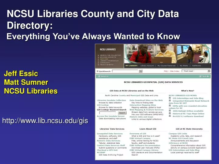
NCSU Libraries County and City Data Directory: Everything You’ve Always Wanted to Know Jeff Essic Matt Sumner NCSU Libraries. http://www.lib.ncsu.edu/gis. County GIS Links. County GIS Links. Link to Municipal Directory. Popularity – Consistently within:.

E N D
NCSU Libraries County and City Data Directory: Everything You’ve Always Wanted to Know Jeff Essic Matt Sumner NCSU Libraries http://www.lib.ncsu.edu/gis
County GIS Links
County GIS Links Link to Municipal Directory
Popularity – Consistently within: • Top 5 of Libraries Entry pages • Top 10 of Libraries pageviews
History • Started August 2000 by Steve Morris • Steve knew of 8 maps services but found 7 more – realized map servers were beginning to quickly emerge and the need to have a link page • Pre-Google – “Links” pages were more relied upon • Dan Madding 2002: NC OneGIS
City GIS Links • Less Comprehensive • Larger number of • municipalities • Fewer municipal • services • Most data is • incorporated into • county services http://www.lib.ncsu.edu/gis/cities.html
Library Holdings • php template • External links • Related City GIS • Wikipedia • Links to NCSU Geodata • server • All vector data • Some raster data http://lib.ncsu.edu/gis/counties/codata.php...
GIS Websites • Preferably: • - Contact Info • - Dept. organization • - Links to: • Map Server • Data Download or • other acquisition • Related Depts. • Map Gallery • Disclaimers • Metadata • GIS help http://www.co.union.nc.us/PropertyServices/GISMaps/tabid/82/Default.aspx
Map Servers • Link directly to • Disclaimer statement • when possible http://imaps.co.wake.nc.us/imaps/main.htm...
NC OneMap • Orthophotos • Links directly to NC • OneMap Orthophoto • download section http://www.nconemap.net/datacatalog
.ims Files • Provided by Dan • Madding, NCDA • Allow connection of • ArcMap to ArcIMS • servers • 3 known WFS Services in • NC: Henderson Co, • Sampson Co, Town of • Highlands (Macon Co) • Others? Save .ims file to C:\Documents and Settings\USERNAME\Application Data\ESRI\ArcCatalog
WMS Links • WMS Links • Maintained by • NC OneMap • Both .ims and WMS • services are useful for: • Counties that don’t • provide data • downloads • Potential web-based • applications http://www.nconemap.net/datacatalog
Maintenance • Originally: • Static • HTML • Now: • Dynamic • php/MySQL • Persistent ID table • Advantages • Fast • Status Maps • Fool-proof HTML http://www.lib.ncsu.edu/gis/counties.html
Persistent Ids • Purpose: • One update – • multiple uses • Clicks get recorded • in logs • Structure • Resolver script • Query parameter • using FIPS code http://www.lib.ncsu.edu/cgi-bin/getloc.pl?loc=G37001ws
Link Maintenance • Average approx. 15 min. per week • Check links approx. twice / yr • students & interns • Heavily depend on new/broken link reports from users
GIS Lookup • Searches containing an NC County name returns a link to the • Library Holdings page
Google Search • Usually: • County GIS Links • 1st or 2nd hit • Library Holdings • 2nd or 3rd hit http://www.google.com
NC Counties with GIS Map Server 93 / 100 5 Sep. 2008
NC Counties with GIS Download 50 / 100 5 Sep. 2008
NC Counties with WMS 58 / 100 5 Sep. 2008
County Mapping and Data Services in NC • 100 Counties in NC
Counties.html Filtered Page Hits by FY Anomaly due to spider filtering problems.
Comparison of Online County GIS Services: Ten Counties that had all services during FY 07-08
Clicks by County to Library Holdings Pages NCSU Only Clicks NCSU : non-NCSU 1:13.5 All Clicks
Clicks by County to GIS Contact/Info Pages NCSU Only Clicks NCSU : non-NCSU 1:57.1 All Clicks
Clicks by County on Map Server Links NCSU Only Clicks NCSU : non-NCSU 1:51.8 All Clicks
Clicks by County on Public Download Links NCSU Only Clicks NCSU : non-NCSU 1:13 All Clicks
Clicks by County on .ims files NCSU Only Clicks NCSU : non-NCSU 1:8.8 All Clicks
Clicks by County on WMS links NCSU Only Clicks NCSU : non-NCSU 1:2.5 All Clicks
NCGDAP (NDIIPP) • NCSU Libraries • NCCGIA • Library of Congress • Objective: • Engage existing • state/federal SDI • in preservation • Dspace depository • No remote access • Focus on archiving • annual “snapshots”
Roanoke • Network data access • Mapped from • PC and Mac • Campus ID/pass • Vector data archive • Most orthos stored on CD • Collection spans ~ 8 • years
Future Desires • Add local govt. • GIS data records into • the main library catalog • Be able to extract • Contact and Framework • info from RAMONA http://www.lib.ncsu.edu/catalog http://www.nc.gisinventory.net
Feedback - Missing/Broken Links? - Suggestions for improvement? - Questions? Jeff Essic jeff_essic@ncsu.edu Matt Sumner matt_sumner@ncsu.edu