Download

1 / 22
220 likes | 448 Views
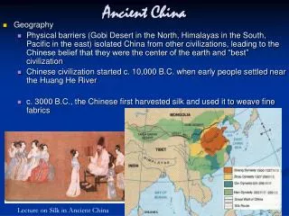
Ancient China. Ancient History 10. Physical Features of China. Physical Features of China. China is the largest landmass in Asia Today it has: 22 provinces, 4 municipalities and 5 autonomous regions. Capital, Beijing. The physical features highlight: Forest steppes.

E N D
Ancient China Ancient History 10
Physical Features of China • China is the largest landmass in Asia • Today it has: 22 provinces, 4 municipalities and 5 autonomous regions. • Capital, Beijing. • The physical features highlight: • Forest steppes. • Deserts (Gobi and Taklamakan). • Dry regions. • Subtropical forests. • Rugged, high altitudes. • Extensive mountain ranges.
Mountains in China • China was composed of pockets of civilization. • The early people in China settled mostly along the Yangtze River and Yellow River. • These early people were protected from the rest of the world by many natural barriers. • One was the Himalayan Mountains.
Mountains in China • The Himalayan Mountains are not located in modern day China. They run along the border to the south. • Helped to protect from invasion. • The Himalayan Mountains to the south are very rugged.
The Taklamakan Desert • Referred to as Sea of Death. (2nd largest) • It has poisonous snakes, frequent sand storms, boiling days, freezing nights, and intense water shortages. • Bounded by the Kunlun Mountains and the desert Pamir Mountains • 85% made up of shifting sand dunes
Godi Desert in China • One of the driest deserts in the world. • Gobi gets some water • It covers parts of northern and northwestern China, and of southern Mongolia. • The desert basins of the Gobi are bounded by the Altai Mountains, steppes of Mongolia and Tibetan Plateau.
Plateau In China • The Tibetan Plateau is surrounded by massive mountain ranges. • The plateau is bordered to the south by the Himalayan range, Kunlun Range, Tarim Basin, and the Qilian Range. • The Tibetan Plateau has an altitude that drops from around 5,000 metres (16,000 ft) to 1,500 metres (4,900 ft) in less than 150 kilometres.
Manchurian Plain • Manchuria, the northeastern • The area is roughly 1,165,000 km sq. • Manchuria is bordered by: • Mongolia • Russia • North Korea • Yellow Sea.
Manchurian Plain • Manchurian Plain, enclosed by heavily forested mountain ranges and hills. • Climate has long, cold winters and short, warm to hot summers. • Temperatures average about -18° C in January to 22° C in July. • Precipitation normally totals 250 to 630 mm
Tarim Basin • Drained by the Tarim River in western China, • Covers about 906,500 square km and enclosed by the mountains. • The climate is extremely dry since the mountains block out moist air from the sea. • Annual rainfall is less than 4 inches
Rivers in China • Some of their natural features provided fertile soil and safe drinking water. • China has two major river systems – • Yellow River (Huang He) and the Yangtze River (Long River).
Rivers in China • The Yangtze (Long River) is the third longest river in the world. • It is about 4000 miles long. • It floods each year and leaves fertile soil along the banks. • The Yangtze River has high banks, which keeps homes safe from the annual flooding.
Rivers In China • The Huang He (Yellow River) is about 3000 miles long. • The banks along the Huang He River are low. • Civilization in ancient China began along the Yellow River about 5000 years ago. • Nickname "The Great Sorrow". (Reason = homes ruined)