Download
1 / 61
610 likes | 735 Views
Jeff Key, NOAA/NESDIS/STAR NPP Cryosphere Team Lead Paul Meade, Cryosphere Products JAM Inputs from the Cryosphere Products Validation Team. Request for Snow Cover EDR Beta Maturity. DR # 7132 CCR # 474-CCR-13-0945 DRAT discussion: April xx, 2013 AERB presentation: April xx, 2013.

E N D
Jeff Key, NOAA/NESDIS/STAR NPP Cryosphere Team Lead Paul Meade, Cryosphere Products JAM Inputs from the Cryosphere Products Validation Team Request forSnow Cover EDR Beta Maturity DR # 7132 CCR # 474-CCR-13-0945 DRAT discussion: April xx, 2013 AERB presentation: April xx, 2013
Outline • Snow Cover EDR Users • Beta EDR Maturity Definition • Summary of Snow Cover EDR • Snow Cover EDR requirements • History of Algorithm Changes/Updates • Beta Maturity Evaluation • Beta Justification Summary • Caveats of Operational Snow Cover EDR • Additional Supporting Documentation • Future Plans Toward Provisional Status • Conclusions
Snow Cover EDR Product Users • U.S. Users • NSIDC - National Snow Ice Data Center (Florence Fetterer ?) • NIC - National/Naval Ice Center (Pablo Clemente-Colon ?) • OSPO - Office of Satellite and Product Operations (Vanessa Griffin ?) • NOHRSC - National Operational Hydrological Remote Sensing Center (?) • STAR - Center for Satellite Applications and Research (Peter Romanov ?) • CLASS - Comprehensive Large Array-data Stewardship System (John Bates) • User Community • Agriculture • Hydrology • Transportation • Emergency Management • DOD
Beta EDR Maturity Definition • Early release product. • Minimally validated. • May still contain significant errors. • Versioning not established until a baseline is determined. • Available to allow users to gain familiarity with data formats and parameters. • Product is not appropriate as the basis for quantitative scientific publication studies and applications.
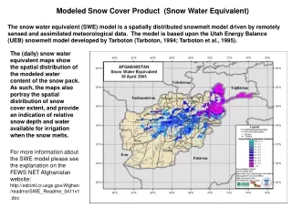
VIIRS Snow Cover EDR • The VIIRS Snow Cover/Depth Environmental Data Record (EDR) products consist of a snow/no snow binary map and snow fraction in a horizontal cell. • The objective of the VIIRS retrieval is to achieve the performance specifications designed to meet the requirements stated in the NPOESS System Specification. • The specifications apply under clear, daytime conditions only. Surface properties cannot be observed through cloud cover by a Visible/Infrared (VIS/IR) sensor. • The specification for the NPOESS Snow Cover/Depth EDR places requirements on the VIIRS binary map product and the VIIRS snow fraction product.
Specification of the VIIRS Binary Map RGB Image shows dense smoke (high absorption) in northwest, north central and central coastal portions of image. 6
Specification of the VIIRS Snow Fraction RGB Image shows dense smoke (high absorption) in northwest, north central and central coastal portions of image. 7
Summary of the Snow Cover EDR Algorithm Inputs Snow Cover EDR Algorithm NPOESS xDRs & IPs Output EDRs & IPs VIIRS 375m SDRs I1, I2, I3, I5 VIIRS 750m SDRs M15, M16 VIIRS 375m TC GEO VIIRS 750m TC GEO VIIRS Cloud Mask IP VIIRS AOT IP VIIRS COP IP VIIRS Snow Cover Binary Map EDR VIIRS Snow Cover Fraction EDR Auxiliary Data VIIRS Snow Cover Tunable Parameter File VIIRS Snow Cover Quality Tunable Parameter
Snow Cover EDR Processing Flow Load and check SDR Reflectance and Brightness Temperatures VIIRS 375m SDRs I1, I2, I3, I5 VIIRS 750m SDRs M15, M16 VIIRS 375m TC GEO VIIRS 750m TC GEO VIIRS Cloud Mask IP VIIRS AOT IP VIIRS COP IP Initial Pixel Quality Checks Construct VIIRS Imagery Resolution Snow Binary Map (NDSI based algorithm) NDSI = (R0.64mm – R1.61mm) / (R0.64mm + R1.61mm) > 0.4 R0.865mm > 0.11 T11.45mm (TOA brightness temperature) < 281 K For NDSI between 0.1 and 0.4 NDVI thresholds as a function of NDSI are used: NDVI = (R0.865mm-R0.64mm)/(R0.64mm+R0.865mm) ndvi_lower = a1 + a2*NDSI ndvi_upper = b1 + b2*NDSI + b3*NDVI2+ b4*NDVI3 ( Klein et al., 1998) Construct EDR Quality Flags for Snow Binary Map and Snow Fraction Map Snow Write Snow Binary Map and Snow Fraction Map Products Construct VIIRS Moderate Resolution Snow Fraction Map 2x2 aggregation of Snow Binary Map
Snow Cover EDR Algorithm • The VIIRS Snow Cover EDR algorithm is an adaptation of the heritage MODIS SnowMap algorithm (Hall et.al 2001) that classifies snow based upon the Normalized Difference Snow Index (NDSI) and additional reflectance, thermal and NDVI thresholds. • The EDR consists of two products: (1) snow binary map (375 m spatial resolution @nadir) and (2) a snow fraction map (750 m spatial resolution @nadir) that is derived from the binary map as a 2x2 aggregated snow fraction. • The VIIRS algorithm adaptations from that of the MODIS heritage are: (1) use of a TOA brightness temperature for thermal false snow screening instead of a surface temperature and (2) use of the VIIRS imagery resolution 0.645µm (I1) reflectance in the NDSI instead of the 0.555 µm reflectance used by the MODIS algorithm.
Beta Maturity Evaluation of the Binary Snow Cover Map Product
Beta Maturity Evaluation Approach, Binary Snow Cover (1/3) • Maturity evaluation approach: • Visual analysis of the product, identification of obvious failures of the algorithm/product including • Missed snow in the regions which are known to be always snow covered at the time of the year when observations were made • Mapped snow in the regions which are known to be always snow-free at the given time of the year • Comparison of VIIRS Snow Cover EDR with independent in situ and remote sensing-based information on the snow cover distribution including • In situ snow cover observations • IMS interactive snow cover analysis • MODIS Terra/Aqua snow cover maps • METOP AVHRR snow cover maps DRAFT
Beta Maturity Evaluation Approach, Binary Snow Cover (2/3) • Details: • Evaluation has been performed • Globally for the visual analysis and when comparing with MODIS and AVHRR products • Over Northern Hemisphere when comparing with IMS • Over Continental US (CONUS) when comparing to station data • Time period when comparison has been conducted • Routine comparison since the beginning of the VIIRS snow product generation • Maturity assessment is based on the VIIRS snow maps generated in the last four months period (December 2012-March 2013) when no major changes were introduced to the VIIRS cloud mask (VCM) • VIIRS global snow data were acquired and processed on every third day
Beta Maturity Evaluation Approach, Binary Snow Cover (3/3) • More details: • Preprocessing of VIIRS snow retrievals • All daily granules have been processed to generate gridded daily global snow cover map • 1, 5 km and 10 km grid cells size • Two cloud masks were tested, “conservative” and “relaxed” • “relaxed” cloud mask included observations identified as “confidently cloudy” and “probably cloudy” • “conservative cloud mask included observations identified as “confidently cloudy” , “probably cloudy” and “probably clear”
Beta Maturity Evaluation, Qualitative analysis of VIIRS binary snow maps VIIRS snow map Qualitative analysis of the VIIRS Binary Snow maps (which are part of the Snow Cover EDR) has shown that this product provides realistic characterization of the global-scale snow cover distribution. In clear sky portions of the image snow mapped by VIIRS closely corresponds to the snow cover identified interactively by IMS analysts. IMS Snow and Ice Chart snow cloud land No data February 12, 2013
Beta Maturity Evaluation – VIIRS vs MODIS Binary Snow Map NPP-Suomi VIIRS snow cover map Visual analysis has shown that VIIRS binary snow maps compare well to MODIS Aqua snow maps. There are some differences in the cloud mask applied in the two products. No severe overestimates or underestimates of the snow cover have been found in the VIIRS snow product. MODIS Aqua snow cover map March 2, 2013 (day 2013061)
Beta Maturity Evaluation – VIIRS vs IMS Quantitative Comparison Omission (snow miss) Commission (false snow) To facilitate the analysis of the VIIRS binary snow product accuracy we have brought VIIRS and IMS snow maps to the same projection and generated an overlay of the two maps. VIIRS binary snow cover with IMS overlaid (March 2, 2013) White: VIIRS & IMS snow Light Gray: VIIRS clouds Green: VIIRS & IMS snow-free land Dark gray: not processed, or no data VIIRS snow map errors: The agreement between the two maps on the snow cover distribution calculated in cloud-clear portions of the VIIRS product over the Northern Hemisphere was 98.3%. Omission and commission errors comprised 1.6 and 0.1% respectively. Snow omissions occur mostly over densely forested areas.
Beta Maturity Evaluation – VIIRS Binary Snow vs IMS Time Series Time series of estimates of correspondence between the VIIRS binary snow map and the IMS snow product • VIIRS binary snow map data aggregated within 4 km size grid cells • Each 4 km grid cell was then labeled according to the dominant category of pixels in it • Comparison was performed by matching the two products grid cell by grid cell • “Total hits” include snow-snow and land-land correct classifications • “Total errors” include VIIRS snow misses and VIIRS false snow identifications • The percent of Clear Sky Pixels in the VIIRS product is given for the 25-600 N latitude band • A noticeable drop in the amount of available cloud-clear grid cells in the VIIRS product in October 2012 corresponds to substantial changes the cloud team introduced to the cloud algorithm. Since the end of 2013 the agreement between the two products over Northern Hemisphere remains above 98%.
VIIRS Binary Snow Map vs In Situ Snow Observations Daily statistics of correspondence between VIIRS snow and in situ data. Location of US Coop Stations “Total hits” include correct snow-snow and land-land classifications “Total errors” include VIIRS snow misses and VIIRS false snow identifications Observations from US Cooperative network stations over Continental US have been used. The number of daily VIIRS-in situ match ups ranges from 150 to 1030. Except of one day disagreement between VIIRS daily snow retrievals and in situ data did not exceed 10%.
VIIRS Binary Snow Cover: Cloud Flag Issue (1/2) VIIRS snow maps were produced with two cloud masks, “relaxed” and “conservative”. The “relaxed” cloud mask included “confidently cloudy” and “probably cloudy” categories. The “conservative ” cloud mask included “confidently cloudy”, “probably cloudy” and “probably clear” categories. . “Relaxed” cloud mask used “Conservative” cloud mask used White: snow Light Gray: clouds Green: snow-free land Dark gray: not processed, or no data) Maps with “conservative” cloud mask have noticeably more clouds than maps with the “relaxed” cloud mask
VIIRS Binary Snow Cover: Cloud Flag Issue (2/2) Omission (snow miss) Commission (false snow) VIIRS maps with different cloud masks were compared with the IMS product. “Conservative” cloud mask used White: VIIRS & IMS snow Light Gray: VIIRS clouds Green: VIIRS & IMS snow-free land Dark gray: not processed, or no data VIIRS snow map errors: “Relaxed” cloud mask used The snow product with a “conservative” cloud mask tends to miss less snow as compared to the snow map with the “relaxed” cloud mask. Therefore at this time it is recommended to us the “conservative” cloud mask.
VIIRS Binary Snow Cover: Other Issues The use of “conservative” cloud mask results in the cloud clear snow cover scenes frequently labeled as cloudy. VIIRS RGB granule image VIIRS granule snow product snow cloud land No data / not processed
VIIRS Binary Snow Cover: Other Issues Portion of VIIRS global gridded snow map over South America on Jan 13, 2013 Some clouds are missed by the VIIRS cloud mask (VCM). Missed clouds are most often interpreted as snow and thus may appear in the snow product as spurious snow. The extent of spurious snow cover is small compared to the true snow. However these errors tend to accumulate in the VIIRS clear sky snow/ice composited images and affect other VIIRS products that rely on them (e.g., LST, NDVI, Albedo, etc) snow land cloud
VIIRS Binary Snow Cover: Other Issues VIIRS snow cover, January 31, 2013 (day 2013031) Occasional failures to detect snow shadowed by clouds were noticed in the VIIRS snow product snow cloud land DRAFT
VIIRS Binary Snow Cover: Other Issues Snow misses in the VIIRS snow product tend to occur more frequently when observations are made in the backscatter
Beta Justification Summary: Binary Snow Cover • Criteria: Early release product • Snow Cover EDR performance is dependent on VIIRS SDR, VIIRS Cloud Mask IP and the Aerosol Optical Thickness IP • VIIRS SDR Cal and Geo products reached provisional maturity in March, 2013. • VIIRS Cloud Mask IP reached provisional maturity in February, 2013 • VIIRS Aerosol Optical Thickness reached beta maturity in September 2013 • VIIRS COP IP has reached beta maturity in March 2013 • Criteria: Minimally validated • Evaluation is based on a limited number of focus days (global comparisons for retrieval products) • About 40 days during December 2012-March 2013 time period • Earlier evaluation results are not valid because of significant modifications introduced to the cloud mask prior to this time period.
Beta Justification Summary: Binary Snow Cover (2/3) • Criteria: Available to allow users to gain familiarity with data formats and parameters • Cryosphere Snow Cover EDR team has evaluated IDPS EDR products available from STAR Central Data Repository (SCDR). Same products are available at NOAA CLASS • Users can access and read the products and the product compares reasonably with the heritage satellite snow map products • Beta release will allow other users within the community to gain experience with the data formats and parameters. • This is important to allow users to complement the validation activity.
Beta Justification Summary: Binary Snow Cover • Criteria: Product is not appropriate as the basis for quantitative scientific publication studies and applications • The product has known flaws as shown in this presentation, but these products are of sufficient quality to justify use by a broader community • The product may change considerably with the further expected changes to the VIIRS cloud mask. • Most of the issues • Missing and false snow may be linked to maturing, improving VIIRS Cloud Mask (VCM) and out of date (not daily updated) Grid-VIIRS-Snow-Ice-Cover-Rolling Tiles that affect performance. • Comprehensive estimates of the VIIRS snow cover product will become possible once the VIIRS cloud mask algorithm is finalized and allowed to run unchanged for a period of several months. The decision on the provisional status of the product will be made when these estimate are made.
Future Plans and Issues:Binary Snow Cover Product • Several changes/modifications to the Binary Snow Map algorithm are considered • Spatial-based filter to identify potentially spurious snow • Climatology-based filter to identify “false snow” • Changes to the algorithm threshold values to improve snow detection • In the backscatter • Over forested areas • Detailed performance characterization requires: • Comprehensive evaluation of the product stratified by the season of the year, climatic/geographic zone and surface cover type • A more detailed analysis of the algorithm and product performance at local scales • Further validation of the VIIRS Binary Snow Map product with the most recent cloud mask is needed before the decision on the provisional maturity of the product can be made
Conclusion: Binary Snow Cover Product • The VIIRS Binary Snow Cover Product (which is part of the VIIRS Snow Cover EDR) has met the beta maturity stage based on the definitions and the evidence shown • It exceeds the definition of beta in most cases • The product performance is close to meeting requirements at this time. • Issues have been uncovered during validation of the VIIRS Binary Snow Cover Product and solutions are being evaluated. • Identified problems are mostly related to failures of the VIIRS cloud mask algorithm and product • If the accuracy of the cloud mask does not change as the result of latest improvements, modifications to the VIIRS Binary Snow Map algorithm should be introduced to at least partially compensate for the cloud mask errors
Beta Maturity Evaluation of the Fractional Snow Cover Product
Binary Snow Product vs Snow Fraction “Snow cover is the fraction of a given area of the earth’s horizontal surface that is masked by snow. In addition, a binary snow/no-snow mask will be produced.” JPSS Level 1 Requirements, SUPPLEMENT – Final, Version: 2.3 11/02/2012 • Different requirements • Imagery vs moderate resolution • Binary classification vs continuous range from 0 to 1 • Different physical meaning and approaches to retrievals • Absence / presence vs relative coverage • Different presentation • Thematic maps vs fraction maps • Different validation • Probability of correct classification vs uncertainty
History of Algorithm Evolution 1998-1999 Multiple Endmember Spectral Mixture Analysis (MESMA) developed, implemented, tested and evaluated • Inclusion of BRDF correction factor 2004 Development of modeled Snow Reflectance LUT 2005 Optional processing of snow cover fraction from the binary mask using 2x2 aggregation of the imagery resolution snow binary map incorporated 2007a MESMA “algorithm for computing snow fraction has been developed but is not being implemented operationally “ 2007b “2x2 binary map aggregation based snow fraction will be implemented operationally for NPP in place of MESMA” 2010 Sections related to the MESMA snow fraction algorithm eliminated
MESMA Multiple Endmember Spectral Mixture Analysis (MESMA) uses the reflectances in nine VIIRS moderate resolution reflectance bands to retrieve snow fraction. An objective of any spectral mixture analysis is the definition of sub pixel proportions of spectral endmembers that may be related to mappable surface constituents. Spectral mixture analysis “unmixes” the mixed pixel, determining the fractions of each spectral endmember that combine to produce the mixed pixel’s spectral signature. The approach is to model the signature from each pixel as a combination of two components: a modeled snow reflectance spectrum and a modeled non-snow reflectance spectrum. The approach is based on the assumption that the non-snow endmember spectrum for each pixel can be estimated from non-snow surface BRDF that will be obtained from the VIIRS Gridded Surface Albedo IP
MESMA Performance Analysis (1999) Snow Fraction Measurement Uncertainty: Stratified Performance for Typical Case
Conclusion of the NOAA Task “Generating and Validating NPOESS Snow … Products” (2009) • Testing of fractional snow algorithm shows ways to significantly improve the quality of retrieval • The first issue requiring consideration is Snow Reflectance LUT • Additional algorithm modifications are required to meet specifications • Specifications for snow EDRs could be attainable
Snow Fraction (ATBD of 2011) • “The snow fraction algorithm has undergone significant development since the Critical Design Review (CDR).” • Snow fraction computed using 2x2 aggregation of the binary snow mask, results in reporting of snow fraction in 25% increments. • “The performance of snow fraction is determined by the performance of the snow binary map since the snow fraction is based on a 2x2 aggregation of the snow binary map pixels.” • “The snow fraction algorithm will produce an error estimate for each pixel.”
Beta Maturity Evaluation Approach • Daily global calculations of snow fraction aggregated within grid cells of different scales (from 1 km to 0.3°) were used to identify the areas of significant errors. • Calculated results of fractional snow cover products were compared locally with VIIRS false color imagery presenting ground truth to explore the commission and omission errors in calculations and determine possible reasons of the errors. • The comparisons of calculations with ground truth were made at the highest possible resolution at pixel scale for 5 min granule in the natural satellite coordinates with X axis corresponding to scan line and Y axis parallel to satellite motion. • The calculations with modified approach were repeated for individual days to assess the influence of corrections and averaged for a month to consider a systematic picture of changes in the results of calculations
Example of Omission Errors Due to Missing Clouds (yellow zone within white snow cover) 100% 75% 50% 25% Non- Snow Water Clouds Boreal forest False color image Snow thematic map
Current Status of Snow Cover Processing The following improvements have been implemented for calculations: • New updated cloud mask is used • Snow retrieved only for “confidently clear” pixels • Speckle-like false snow in low latitudes is removed by applying double filtering (Minimum number of observations and snow fraction above 0.1) The following results are obtained: • Daily global calculations provide a systematic picture of Snow Cover distributions without significant commission and omission errors • The areas of lower snow fraction are associated with the influence of boreal forest mostly in Europe and Asia and to much less degree in Eastern and Western Canada
Snow Cover on March 29 and 30, 2013(calculations illustrate consistency)
Satisfactory Retrieval of Snow Line(border between snow and non-snow) The locations of snow free (yellowish) regions in the thematic map (top) closely correspond to the areas without snow easily distinguishable in the false color image (bottom)
Transition Zones from Snow Covered Regions to Snow Free Areas are Very Narrow VIIRS fraction Image MODIS fraction
Loosing Details of Fraction Distributionswithin the Snow Zone VIIRS fraction MODIS fraction
Missing Snow Structure in VIIRS Fractional Snow Product M 100% 75% 50% 25% Non- Snow Water Clouds False color image VIIRS snow fraction
Comparison of Snow Fractions Simple simulation VIIRS Product 0% 100%