Download
1 / 5
50 likes | 204 Views
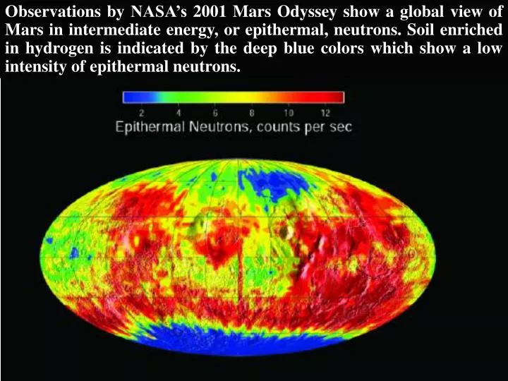
Observations by NASA’s 2001 Mars Odyssey show a global view of Mars in intermediate energy, or epithermal, neutrons. Soil enriched in hydrogen is indicated by the deep blue colors which show a low intensity of epithermal neutrons. NASA’s 2001 Mars Odyssey spacecraft provided this

E N D
Observations by NASA’s 2001 Mars Odyssey show a global view of Mars in intermediate energy, or epithermal, neutrons. Soil enriched in hydrogen is indicated by the deep blue colors which show a low intensity of epithermal neutrons.
NASA’s 2001 Mars Odyssey spacecraft provided this view of the south pole of Mars in inter- mediate energy, or epithermal neutrons. Soil enriched in hydrogen is indicated by the deep blue colors on the map, where a low intensity of epithermal neutrons is found. This view of the south pole of Mars comes from measurements made in the first week of Mars Odyssey’s mapping, in February 2002.
Observations from NASA’s 2001 Mars Odyssey produced this high energy neutron detector map of martian neutrons in the southern hemisphere. The blue region around the south pole indicates a high content of hydrogen in the upper 2 to 3 meters (7 to 10 feet) of the surface. HEND NEUTRONS
The first images from NASA’s 2001 Mars Odyssey show mixed terrain in a daytime infrared image.
The first high resolution map of significant wave height and ocean wind speed from Jason 1 oceanography satellite: a joint effort by NASA and French Centre Nationale d’Etudes Spatiales to monitor the global climate interactions. Jason, cycle 002, Period: Jan 25-Feb 4, 2002