Download
1 / 1
10 likes | 101 Views
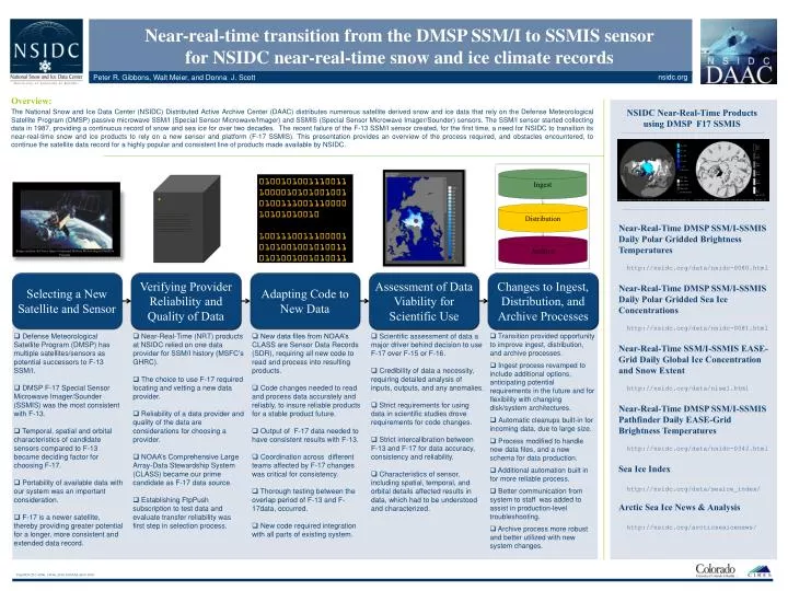
Final ID C21C-0566, 14 Dec 2010, 8:00AM, AGU 2010 . Near-real-time transition from the DMSP SSM/I to SSMIS sensor for NSIDC near-real-time snow and ice climate records. nsidc.org. Peter R. Gibbons, Walt Meier, and Donna J. Scott . Overview:. NSIDC Near-Real-Time Products

E N D
Final ID C21C-0566, 14 Dec 2010, 8:00AM, AGU 2010 Near-real-time transition from the DMSP SSM/I to SSMIS sensor for NSIDC near-real-time snow and ice climate records nsidc.org Peter R. Gibbons, Walt Meier, and Donna J. Scott Overview: NSIDC Near-Real-Time Products using DMSP F17 SSMIS The National Snow and Ice Data Center (NSIDC) Distributed Active Archive Center (DAAC) distributes numerous satellite derived snow and ice data that rely on the Defense Meteorological Satellite Program (DMSP) passive microwave SSM/I (Special Sensor Microwave/Imager) and SSMIS (Special Sensor Microwave Imager/Sounder) sensors. The SSM/I sensor started collecting data in 1987, providing a continuous record of snow and sea ice for over two decades. The recent failure of the F-13 SSM/I sensor created, for the first time, a need for NSIDC to transition its near-real-time snow and ice products to rely on a new sensor and platform (F-17 SSMIS). This presentation provides an overview of the process required, and obstacles encountered, to continue the satellite data record for a highly popular and consistent line of products made available by NSIDC. Ingest 01001010011100111000010101001001010011100111000010101010010 100111001110000101010010010100110101001001010011 Distribution • Near-Real-Time DMSP SSM/I-SSMIS Daily Polar Gridded Brightness Temperatures • http://nsidc.org/data/nsidc-0080.html • Near-Real-Time DMSP SSM/I-SSMIS Daily Polar Gridded Sea Ice Concentrations • http://nsidc.org/data/nsidc-0081.html • Near-Real-Time SSM/I-SSMIS EASE-Grid Daily Global Ice Concentration and Snow Extent • http://nsidc.org/data/nise1.html • Near-Real-Time DMSP SSM/I-SSMIS Pathfinder Daily EASE-Grid Brightness Temperatures • http://nsidc.org/data/nsidc-0342.html • Sea Ice Index • http://nsidc.org/data/seaice_index/ • Arctic Sea Ice News & Analysis • http://nsidc.org/arcticseaicenews/ Archive Image courtesy Air Force Space Command Defense Meteorological Satellite Program Selecting a New Satellite and Sensor Verifying Provider Reliability and Quality of Data Adapting Code to New Data Assessment of Data Viability for Scientific Use Changes to Ingest, Distribution, and Archive Processes • Defense Meteorological Satellite Program (DMSP) has multiple satellites/sensors as potential successors to F-13 SSM/I. • DMSP F-17 Special Sensor Microwave Imager/Sounder (SSMIS) was the most consistent with F-13. • Temporal, spatial and orbital characteristics of candidate sensors compared to F-13 became deciding factor for choosing F-17. • Portability of available data with our system was an important consideration. • F-17 is a newer satellite, thereby providing greater potential for a longer, more consistent and extended data record. • Near-Real-Time (NRT) products at NSIDC relied on one data provider for SSM/I history (MSFC’s GHRC). • The choice to use F-17 required locating and vetting a new data provider. • Reliability of a data provider and quality of the data are considerations for choosing a provider. • NOAA’s Comprehensive Large Array-Data Stewardship System (CLASS) became our prime candidate as F-17 data source. • Establishing FtpPush subscription to test data and evaluate transfer reliability was first step in selection process. • New data files from NOAA’s CLASS are Sensor Data Records (SDR), requiring all new code to read and process into resulting products. • Code changes needed to read and process data accurately and reliably, to insure reliable products for a stable product future. • Output of F-17 data needed to have consistent results with F-13. • Coordination across different teams affected by F-17 changes was critical for consistency. • Thorough testing between the overlap period of F-13 and F-17data, occurred. • New code required integration with all parts of existing system. • Scientific assessment of data a major driver behind decision to use F-17 over F-15 or F-16. • Credibility of data a necessity, requiring detailed analysis of inputs, outputs, and any anomalies. • Strict requirements for using data in scientific studies drove requirements for code changes. • Strict intercalibration between F-13 and F-17 for data accuracy, consistency and reliability. • Characteristics of sensor, including spatial, temporal, and orbital details affected results in data, which had to be understood and characterized. • Transition provided opportunity to improve ingest, distribution, and archive processes. • Ingest process revamped to include additional options, anticipating potential requirements in the future and for flexibility with changing disk/system architectures. • Automatic cleanups built-in for incoming data, due to large size. • Process modified to handle new data files, and a new schema for data production. • Additional automation built in for more reliable process. • Better communication from system to staff was added to assist in production-level troubleshooting. • Archive process more robust and better utilized with new system changes.