Download
1 / 12
140 likes | 493 Views
ACCURACY OF PHOTOMOD AERIAL TRIANGULATION. Ivan KATZARSKY, Vanya PETROVA GIS SOFIA Ltd., Bulgaria. INTRODUCTION. For evaluation the capacity of a digital photogrammetric system of special importance is the accuracy of the aerial triangulation

E N D
ACCURACY OF PHOTOMOD AERIAL TRIANGULATION Ivan KATZARSKY, Vanya PETROVA GIS SOFIA Ltd., Bulgaria
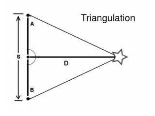
INTRODUCTION • For evaluation the capacity of a digital photogrammetric system of special importance is the accuracy of the aerial triangulation • An experiment in 4 variants in Photogrammetry Department at GIS SOFIA Ltd. determines the accuracy of PHOTOMOD
SOFIA MUNICIPALITY Test area TEST AREA Test area characteristics • Area: 3103 hectares • Terrain: flat, lightly hilly and hilly not dense urban area with predominantly low houses • Average height of the terrain above sea level: 750 m Aerial photography • Contractor: Hansa Luftbild Sensorik und Photogrammetry GmbH, Münster • Execution of the photo-flight: 19.05.2006 • Aircraft: Cessna 404 Titan • Aerial camera: Zeiss RMK TOP 30/23 (Z/I Imaging) • Overlap between the pictures: forward 60 %, side 30 % • Aerial film: Kodak Aerocolor Negative 2444 III, 19 DIN • Film processor: Colenta
Scanning DELTASCAN GeoSystemScientific Production Enterprise 12 μm pixel size Land surveying Pre-marked on the terrain ground control and check points, determined by GPS-receiver Topcon GGD with an accuracy of ± 2 cm in position and ± 3 cm in height
EXPERIMENT DESCRIPTION General information • Blocks of aerial pictures……………………………………………….. 1 • Strips of aerial pictures………………………………………………… 6 • Aerial pictures…………………………… 14+17+18+18+19+19 = 105 • Approximate picture scale…………………………………….. 1 : 4710 • Average flight height above the terrain, m……………………… 1440 • Ground pixel size, cm………………………………………………. 5.7 • Pre-marked points on the terrain……………………………………. 36 • Pictures per 1 pre-marked point……………………………………… 3 • Tie points…………………………………………………………….. 786
Experimented variants Aerial triangulation by PHOTOMOD 4.2 modules • PHOTOMOD Montage Desktop • PHOTOMOD AT • PHOTOMOD Solver Polynomial correction of 2nd degree in X, Y and Z axes are applied
RESULTS The accuracy of aerial triangulationis evaluated by mean square differences between geodetic and photogrammetric coordinates of the ground control and check points Accuracy on the terrain, based on ground control points
ANALYSIS The mean square differences between geodetic and photogrammetric co-ordinates of theground control points are in the following range • In X-axis : ± 3.2 cm to ± 3.8 cm • In Y-axis : ± 1.1 cm to ± 3.7 cm • In XY-plane : ± 4.0 cm to ± 5.0 cm • In Z-axis : ± 2.3 cm to ± 7.1 cm The mean square differences between geodetic and photogrammetric co-ordinates of the checkpoints are in the following range • In X-axis : ± 4.5 cm to ± 7.3 cm • In Y-axis: ± 4.3 cm to ± 9.3 cm • In XY-plane: ± 6.3 cm to ± 11.8 cm • In Z-axis: ± 8.0 cm to ± 26.7 cm
CONCLUSIONS • PHOTOMOD aerial triangulation, based on one ground control point • per 4 to 7 pictures, shows best result • The results strongly depend on the experimental conditions and • parameters. It gives an idea only for the capacity of PHOTOMOD • aerial triangulation. Another experiment could show other results • Aerial triangulation carried out by PHOTOMOD shows a reliable • accuracy
THANK YOU FOR YOUR ATTENTION! Authors Assoc. Prof. Dr. Ivan Katzarsky 22 Omourtag Street BG-1124 Sofia, Bulgaria Tel.: +359 (0)2 8466953 GSM: +359 (0)88 5325509 ikatzarsky@abv.bg Vanya Petrova, M.Sc. GIS SOFIA Ltd., Photogrammetry Dept. 5 Serdica Str., BG-1000 Sofia, Bulgaria Tel.: +359 (0)2 9238338; 9307946 GSM: +359 (0)88 6067306 vpetrova@hotmail.com