Download
1 / 1
10 likes | 70 Views
GIS PUBLISHING TO THE WEB CONNECTING SCHOLARLY COMMUNITIES FOR COLLABORATIVE RESEARCH Mediterranean Coast GIS – Semitic Museum, Harvard University. WORLDMAP - DATAVERSE MODEL. Why is the Mediterranean Coast GIS is Important. What does Med Coast GIS do?.

E N D
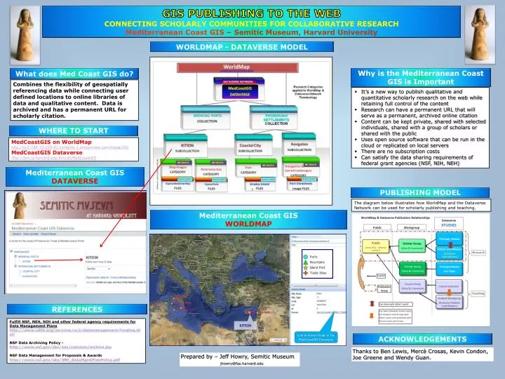
GIS PUBLISHING TO THE WEB CONNECTING SCHOLARLY COMMUNITIES FOR COLLABORATIVE RESEARCH Mediterranean Coast GIS– Semitic Museum, Harvard University WORLDMAP - DATAVERSE MODEL Why is the Mediterranean Coast GIS is Important What does Med Coast GIS do? Combines the flexibility of geospatially referencing data while connecting user defined locations to online libraries of data and qualitative content. Data is archived and has a permanent URL for scholarly citation. • It’s a new way to publish qualitative and quantitative scholarly research on the web while retaining full control of the content • Research can have a permanent URL that will serve as a permanent, archived online citation • Content can be kept private, shared with selected individuals, shared with a group of scholars or shared with the public • Uses open source software that can be run in the cloud or replicated on local servers • There are no subscription costs • Can satisfy the data sharing requirements of federal grant agencies (NSF, NIH, NEH) WHERE TO START MedCoastGIS on WorldMap http://ec2-184-73-229-41.compute-1.amazonaws.com/maps/200 MedCoastGIS Dataverse http://dvn.iq.harvard.edu/dvn/dv/MedCoastGIS Mediterranean Coast GIS DATAVERSE PUBLISHING MODEL The diagram below illustrates how WorldMap and the Dataverse Network can be used for scholarly publishing and teaching. Mediterranean Coast GIS WORLDMAP REFERENCES Fulfill NSF, NEH, NIH and other federal agency requirements for Data Management Planshttp://www.cdlib.org/services/uc3/datamanagement/funding.html NSF Data Archiving Policy - http://www.nsf.gov/sbe/ses/common/archive.jsp NSF Data Management for Proposals & Awards http://www.nsf.gov/sbe/SBE_DataMgmtPlanPolicy.pdf KITION Link to Kition Study in the MedCoastGIS Dataverse ACKNOWLEDGEMENTS Thanks to Ben Lewis, Mercè Crosas, Kevin Condon, Joe Greene and Wendy Guan. Prepared by – Jeff Howry, Semitic Museum jhowry@fas.harvard.edu