Download
1 / 44
440 likes | 542 Views
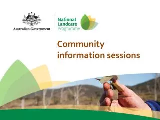
The Nunavut Impact Review Board An Institution of Public Government created by the Nunavut Land Claims Agreement. Community Information Sessions BIPR Part 5 Review, March 2008. Outline of Presentation. Who is NIRB? What does NIRB do? What is a NIRB Review? Why are we here today?

E N D
The Nunavut Impact Review BoardAn Institution of Public Government created by the Nunavut Land Claims Agreement Community Information Sessions BIPR Part 5 Review, March 2008
Outline of Presentation • Who is NIRB? • What does NIRB do? • What is a NIRB Review? • Why are we here today? • Bathurst Inlet Port and Road Project • BIPR File History • How can you participate?
NIRB’s Mission Statement: “To protect and promote the well-being of the Environment and Nunavummiut through the Impact Assessment Process”
NIRB Assessment Process Section 12.4.4 of the Nunavut Land Claims Agreement gives NIRB these four options after assessing a project or activity
What is a Review? A Review is a more detailed environmental assessment of the Project
When is a Review Required? When the project involves potential significant effects on: • Significant public concern • New technology for which the effects are unknown
NIRB screening decision 12.4.4 (b) NLCA NIRB Part 5 Review Flow Chart FEIS Technical Review DEIS Technical Review Minister refers project To Part 5 Review Final Hearing Technical Meeting Issue Scoping NIRB’s Decision (Report to the Minister) Guideline development Pre-Hearing Conference & NIRB Decision Minister’s Decision NIRB receives DEIS NIRB receives FEIS NIRB issues a Project Certificate & holds a regulators meeting Conformity Review NIRB internal Conformity Review to PHC decision EA Post-Mortem
Why are we here today? • We are here to ensure you are aware of the following three things: • The NIRB Review process • The project undergoing Review • Relevant correspondence related to the project
Project Overview • Bathurst Inlet Port and Road (BIPR) project • Port and facilities 40 km South of the community of Bathurst Inlet, about 150 km South of Coronation Gulf • 211 km all-weather road to Contwoyto Lake • 20 person camp at Contwoyto Lake • New road will connect to existing Tibbitt to Contwoyto Winter Road in NWT • Projected 30 month construction period • Minimum 20 year operational period
Project Purpose • Project infrastructure would service the existing diamond mines in the Slave Geological Province • Meant to help attract capital investment for on-going exploration and development of new mines • Meant to help reduce the cost of essential bulk materials to Kitikmeot communities
File History • Original project description submitted to the NIRB • NIRB issues a screening decision, recommends a review under Section 12.4.4b • Minister advises the NIRB to re-screen the project description in light of new correspondence from the Proponent • A revised project description is submitted to the NIRB • The NIRB issues a second screening decision, again recommending the project be sent to a review • The Minister writes to the NIRB, referring the project to a Part 5 Review April 2002 May 2003 September 2003 May 2004 April 2003 July 2002
Minister’s Directions • On May 4, 2004 the Minister of INAC wrote to the NIRB, referring the BIPR project proposal to a Part 5 NLCA Review • “It is my view that a Part 5 Review is appropriate because the physical components of the BIPAR project are located wholly within the Nunavut Settlement Area” • Directed NIRB to consider the potential for transboundary effects and cumulative impacts • “structure the review to enable the best consideration of relevant issues, and to consider a broad participation of the public” • “scope the BIPAR project broadly, and ensure that the interested parties in all the potentially affected jurisdictions have an opportunity to provide input”
File History • The NIRB holds scoping meetings in Kugluktuk, Cambridge Bay and Yellowknife • Further community meetings are held in Cambridge Bay, Kugluktuk and Bathurst Inlet while EIS guidelines are drafted. • The NIRB issues EIS Guidelines to the Proponent • The Proponent submits a Draft Environmental Impact Statement to the NIRB (DEIS) • NIRB commences the Technical Review of the DEIS January 2008 December 2004 February 2008 June – September 2004 October - November 2004
Intervener Funding • The Minister of INAC also directed the NIRB to provide advice on Interveners; “who should participate in the review and who may require funding to do so.” • As a result, the NIRB issued Intervener Funding Guidelines for interested parties to follow, and has received funding applications from 6 Interveners including: • Bathurst Inlet Road and Port Committee • Bathurst Inlet Lodge • Yellowknives Dene First Nation • North Slave Métis Alliance • Canadian Arctic Resources Commission • Inuvialuit Game Council and the Hunters and Trappers Association of Ulukhaktok (joint submission)
What is Scoping? One of the first ways NIRB identifies which components of the environment may be impacted by a project, and what people think about the proposed Project
How was Scoping done? • Public meetings were held by NIRB in Cambridge Bay, Kugluktuk, and Yellowknife in 2004. • People wrote to NIRB to say what they thought about the Project • People called NIRB to tell us what they thought about the Project • People also told the local HTOs and Hamlets what they thought about the Project
Issues Raised • Cumulative Effects • Road • Socio-economic Assessment • Wildlife (including caribou) • Transboundary Effects • Monitoring • Consultation process • Shipping • Traditional Knowledge • Baseline Studies • Abandonment and Reclamation
Issues Raised • Marine and Freshwater Environments • IIBAs and Socio-Economic Agreements • EIS Methodology • Identification of Temporal and Spatial Boundaries • Species at Risk • Alternatives • Project Viability • Fuel Shipping and Storage • Hazardous Materials Management and Emergency Response Plan • And more...
NIRB Process September 2004 December 2004 January 2008
Scope of Impact Assessment • Climate • Air Quality • Noise • Surface Water Quantity • Surface Water Quality and Sediment • Freshwater Aquatic Resources • Freshwater Fish and Fish Habitat • Navigable Waters • Ecosystems and Vegetation • Bedrock Geology, Surficial Material, and Soils • Wildlife and Wildlife Habitat • Marine Water and Sediment • Marine Aquatic Resources
Scope of Impact Assessment • Marine Fish and Fish Habitat • Polar Bears and Seabirds • Marine Mammals • Marine Oil Spill • Heritage Resources • Socio-Economics • Effects of the Environment on the Project • Transboundary Effects Analysis • Environment Management Plan • Cumulative Effects Assessment • Closure and Reclamation
Project Components 1 2 4 3
Port Facilities The proposed site for the port facilities is located on federal crown land at the south end of Bathurst Inlet. The facilities would include the following components: • wharf to serve vessels (up to 50,000 tonnes) delivering fuel and bulk cargo to the port • 250 m long, 30 m wide, 15 m draught • dock to handle barges serving the Kitikmeot communities (excluding Kugaaruk) • 200 person camp and services • 220 million L diesel fuel tank farm • 1200 m airstrip
Port Facilities • Port facilities would also include: • Heliport • Cargo laydown area • Diesel power plant • Sewage treatment plant • Fuel dispensing and loading station • Truck and trailer maintenance shop • Explosives storage • Explosives mixing plant
All-Weather Road • The proposed road would be 211 km long and would pass over 82 km of Inuit Owned Lands and 129 km of federal Crown Lands • 42 quarries identified • 4.7 million cubic metres required for construction • 19 bridges, 38 arch culverts and 47 rock fill fords • Road 8 m wide with turnouts every 1 km • Designed to handle empty trucks traveling at 80 km/h, loaded trucks at 60 km/h • Note: speed limits would be significantly lower than this
Road Operations • Road operations would follow the arctic shipping season • Although designed for all-weather operations, the road would operate from January to April, connecting with the existing winter road to operating mines in NWT • Approximately 73 trucks would operate on the road each year • 58 fuel trucks and 15 cargo trucks • Road maintenance from mid-July to early September
Shipping Route • Marine shipping from the East • From Lancaster Sound (north of Arctic Bay) • Through the Barrow Strait • South through Peel Sound, Franklin Strait, Victoria Strait • Across Queen Maud Gulf, through Dease Strait • South through Bathurst Inlet to the proposed port site
Shipping Operations • Marine Shipping operating schedule: • Marine shipping between mid-July and October 15 • Vessels up to 50,000 tonnes would deliver approximately 300,000 tonnes of fuel and supplies • Ice-breaking support might be required • Up to 7 round trips by tug and barge to deliver fuel and general cargo to the communities • Marine shipping would be from the East only
Cumulative Effects • While the effects of individual actions may be small, the effects of two or more actions may combine to produce cumulative effects that could be considered significant • It is predicted that proposed and future developments would use the project facilities to import supplies and export products. Potential developments include: • Gahcho Kue • Hackett River • Hope Bay Deposits • Izok Lake • The development of these projects is predicted to cause a 300% increase in shipping, truck traffic and emissions to the environment.
Socio-Economics • Fourteen communities within Nunavut and the NWT have been identified as having the potential to be affected by the proposed project. They include: • Nunavut: Kugluktuk, Bathurst Inlet, Cambridge Bay, Umingmaktok, Gjoa Haven, Taloyoak • NWT: Yellowknife, Behchoko, Gameti, Wha Ti, Wekweti, Lutselk’e and Ulukhaktok • As the proposed Project has generated economic interest in both territories, these communities are a potential source of labour, services, and supplies. • NIRB has identified these communities for inclusion in its review process to ensure that public concerns are properly addressed, whether within or outside the Nunavut Settlement Area.
Employment • During the 30 month construction period the project would be expected to employ up to 260 people. • 57 full-time personnel would be required for operation and maintenance, including 6 managers • Accommodations would be provided in the proposed 200 person camp at the port, the 20 person camp at Contwoyto Lake, and two portable road construction camps of 60 and 100 persons. • During operations most employees would live in the Kitikmeot Region, commuting to the camps on a 2 week in/ 2 week out basis.
Closure and Reclamation • Plans for closure and reclamation include: • Removal of buildings and structures • The wharf would not be removed • Re-vegetation of disturbed soils • Removal of bridges and culverts from road • Rip road bed surface where there is an opportunity to reclaim the road • Quarries would be contoured and benched if possible • Contaminated soils would be treated • an environmental monitoring plan would be implemented
Monitoring Programs • Monitoring programs have been outlined for the following: • Climate and air quality • Surface freshwater quality • Bridge maintenance • Re-vegetation, invasive plant species establishment, and metal concentrations in plant tissue • Soil erosion and permafrost • Wildlife • Marine water and sediment • Freshwater and marine fish and fish habitat for the compensation projects • Heritage resources • Socio-economic monitoring, both externally within the communities and internally
YOUR Opportunity • What do you think about the Project? • Do you have any concerns? • Do you have any questions about certain components?
NIRB screening decision 12.4.4 (b) NLCA NIRB Part 5 Review Flow Chart FEIS Technical Review DEIS Technical Review Minister refers project To Part 5 Review Final Hearing Technical Meeting Issue Scoping NIRB’s Decision (Report to the Minister) Guideline development Pre-Hearing Conference & NIRB Decision Minister’s Decision NIRB receives DEIS NIRB receives FEIS NIRB issues a Project Certificate & holds a regulators meeting Conformity Review NIRB internal Conformity Review to PHC decision EA Post-Mortem
How you can participate in the next steps of the Review Process Send your comments to: NIRB PO Box 1360 Cambridge Bay, NU X0B 0C0 Or by fax: 1-867-983-2594 Or by email: lpayette@nirb.ca or rbarry@nirb.ca If you have any questions please call: 1-866-233-3033
BIPR Community Consultation • Have you heard about the Bathurst Inlet Port and Road (BIPR) Project? • Have you attended meetings yet? • Do you have concerns or comments for NIRB to consider?
Youand your knowledgeare a very important part of the Environmental Assessment process!
Questions? • Thank you for your time!