Download
1 / 26
260 likes | 346 Views
Conjunctive ground/surface water/watershed management to secure livelihoods in Marj Sanour, Jenin Governorate November2007-December 2010. REWARD Programme Palestine. Project Setting.

E N D
Conjunctive ground/surface water/watershed management to secure livelihoods in Marj Sanour, Jenin GovernorateNovember2007-December 2010 REWARD ProgrammePalestine
Project Setting The “Conjunctive Ground/ Surface Water/ Watershed Management to Secure Livelihoods in Marj Sanour, Jenin Governorate” Project, is one of the demonstration projects within the REWARD Programme initiated by the DGCS/ WESCANA Project and supported by the IUCN Water and Nature Initiative (WANI), funded by DGIS/ The Netherlands. Up-scaling of methodologies and insights, are realized through the sub-networks on different water resource systems of REWARD’s Regional Water Knowledge Network.
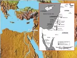
Jenin Governorate • In WBG, Marj Sanour watershed project is implemented in Jenin governorate. • Situated at the northern part of the WB and in the southern part of Jenin Governorate • Governorate area about 583 km². with 258,321 inhabitants. • It is surrounded by 7 villages: • Sanour, Aljarba, Meselieh,Serees; • Seer and Meithaloun .
Marj Sanour Socio-economic conditions 26.500 People • affected socially and economically by the basin; • entirely dependent on groundwater for domestic use.
The climate of the area is characterized by: • a moderate hot and dry summer and by a moderate cool and rainy winter; • average long term rainfall of 540 mm/y; • important flooding every 3 to 5 years from winter rains and snow. Environment Marj Sanour is a valley with good agricultural potential • surrounded by hills. • with an altitude range from 350 m up to 365 m ASL.
The flooding situation diagram Main Water Flow components: 1- Rainfall 2- Water retention on hill slopes 3- Water retention in valley floor 4- Surface run off 5- Evaporation 6- Recharge of the aquifer 7- Seepage of flood water to aquifer 8- Groundwater abstraction by well/ borehole 9- Use of flood water for irrigation 10- Groundwater flow to springs well of Qabatia and Fari’a
Constrains • Lack of trust and confidence by locals • Fragmentation of landownership,influencing any decision process • Low efforts to develop Decision Support System
Project beneficiaries Communities of Marj area, stakeholders, farmers, CBOs, villages, partner NGOs Government institutions Other mountainous area in the region or in other countries From the bottom To the top Best Practice for
Project Donors Project Partners • IUCN Project Office in Palestine • Palestinian Hydrology Group • Union of Agricultural Working Committees Project Stakeholders • Ministry of Agriculture. • Ministry of Local Government. • Palestinian Water Authority. • Environment Quality Affairs.
Project description effective ecosystem/watershed management and conjunctive use of ground and surface water Project long term goal: • to improve rural livelihoods in watershed areas • To increase agricultural development areas through Purpose: Application of systemic and participatory approaches to Integrated Water Resources Management to other mountainous area in the MENA region.
Double face problem (scarcity and flooding) originates from the same root: • Bad land-use • Bad Water management in the watershed
Summer Season Scarcity
Winter season Flooding
Livelihoods of rural households rescued in Marj Sanour Watershed Environmental Hazards decreased Productivity of agricultural land in the valley improved access to ground water in the region( in Al Faraa , Qabatia and Marj Sanour area) for drinking and irrigation increased Productivity of agricultural land in the hills improved Ground water depletion reduced Soil and water conservation of hilly land improved dReduce water loss by evaporation Ground water recharge improved Surface (run off) water coming down the hills reduced Flooding of valley land in heavy rain seasons reduced Water retention techniques improved Adaptive solutions implemented to overcome closed topography of the watershed area and soil impermeability Cultivated and vegetation land increased Use and maintenance of hill terracesimproved Interest, awareness and capacity among farmers raised/built and funds made available to invest in watershed development Long Term Objective Tree
Main Assumption • Improving the productivity of agricultural land • Increasing water availability, by a conjunctive use of ground and surface water.
Key-Pillars Project Strategy Better management of scarce water and land resources through a participatory and stakeholder-led planning process Empowerment Stakeholder Dialogue System Tools
System Tools • A more systemic approach: • to collect and analyze information • to planning and decision-making processes • Under Empowerment. Creating interest/raising awareness. Building Capacity • Under Stakeholders’ Multilevel dialogue/,Long term concerted action • Strong coordination of activities and decision-making
Rural livelihoods in Palestinian watershed areas are rescued Use of systemic, participatory approaches to Integrated Water Resources Management for the mountainous area in the MENA region demonstrated in Marj Sanour watershed A number of tested community pilot activities that can contribute to sustainability of livelihoods Local communities empowered in WR planning and decisions-making and enabled for Plan implementation An operational plan for Marj Sanour watershed development that contributes to livelihoods improvement A general methodology for watershed development strategizing and decision-making endorsed by key stakeholders in Palestine Stakeholder consultation and participatory planning and decision-making Empowerment of local communities and local government agencies Development and endorsement of a watershed development plan for Marj Sanour as a methodology for replication Development of system tools (possibly DSS) to support plan development Conducting studies: water resource assessment, environmental assessments, etc. Development and implementation of community pilot projects to test potential solutions Project Purpose Expected Results
Issues Raised • To involve local people from all surrounding villages in the planning of the project. • To facilitate the dialogue between the implementing partners and the Key Stakeholders. • To enhance Steering Committee role. • To review and verify previous studies
Progress to Date • Stakeholder facilitation and establishing an effective communication system between all stakeholders at different levels. • Establishing Project Steering and Technical Advisory Committees . • Establishing Community Local Committees. • Mobilizing watershed communities. • Promotion for the project idea and increase awareness of the communities on watershed problems and project design. • Agreement on establishing a local watershed development association concluded
Progress to date Cont. • Conducting Draft Hydrological Assesment Study • Identification of the physical boundaries of the watershed that depending on the topographical features of the watershed as a surface water catchment. • Determination of the sub- catchment within the general watershed and their areas. • Classifying and mapping the soil cover in the watershed area. Physical, and chemical properties of soil was determined. • Indicating the geological, structural, and geo-morphological built features of the watershed. • Identifying the different climatologically parameters. • Determining the hydrological parameters (runoff, infiltration, evapotranspiration • Describing the hydro-geological characteristics of the different hydro-geological units depending on their ability of storing and transmitting water.
Progress to date Cont. • Conducting Draft Hydrological Assesment Study Cont. • Describing the hydraulic properties of the aquifer systems. • Identifying the groundwater quality and the hydro-chemical type, through the analyses of different water samples from groundwater wells distributed in the area. • Identifying the water quality of flood water, • Determining the water resources (groundwater wells, cisterns,…) and their capacity for different purposes (domestic, and agricultural). • Studying the situation of water related infrastructure. • Indicating supply, consumption, and demand for the different purposes. Data of these items were collected by using PRA, and records of local councils. • Identifying pollution water resources in the area.
Progress to date Cont. • Socio-Economic Assesment Study almost finalized • investigating the socio-economic characteristics of the Marj Sanour villages (7 villages ) • Studying the main characteristics of the agricultural production systems/patterns and agricultural holdings in the Marj area • Investigating the water availability, access and quality status, and the attitudes of farmers in this regard. • Giving insight on the losses caused by the Marj flooding, and social/economical perceptions vis a vis potential solutions/scenarios for the flooding problem.
Progress to date Cont. • Identification and development of most appropriate and effective DSTs techniques • Building the conceptual Driving Forces-Pressure-State-Impact-Response (DPSIR) framework based on the previous studies and data collected of Marj sanour watershed. • (DPSIR framework is presented as a system for organizing information that emphasizes CAUSE-EFFECT RELATIONSHIPS. It is a methodological framework (or guideline) for decision makers that summarizes key information (indicators) from different sectors. ) • Defining the list of criteria in different aspects (Socio-economic, Environment and Economic) to be quantified and then used for Multi criteria analysis (MCA). • Start building the DSS interface using Visual Studio.Net as a programming language.