Download
1 / 1
10 likes | 16 Views
Global Geocoding Solutions - Adding a location aspect to your projects gives you more insight into your data, improves sales efforts, marketing activity and helps you work more efficiently. Melissa offers highly accurate geocoding with complete global coverage. https://www.melissa.com/in/global-location/geocoder.html

E N D
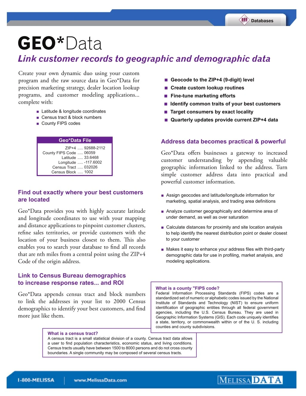
GEO*Data Link customer records to geographic and demographic data Create your own dynamic duo using your custom program and the raw source data in Geo*Data for precision marketing strategy, dealer location lookup programs, and customer modeling applications... complete with: ■ Geocode to the ZIP+4 (9-digit) level ■ Create custom lookup routines ■ Fine-tune marketing efforts ■ Identify common traits of your best customers ■ Target consumers by exact locality ■ Quarterly updates provide current ZIP+4 data ■Latitude & longitude coordinates ■Census tract & block numbers ■County FIPS codes Geo*Data File Address data becomes practical & powerful ..... 92688-2112 ..... 06059 ..... 33.6468 ..... -117.6002 ..... 032026 ..... 1002 ZIP+4 Geo*Data offers businesses a gateway to increased customer understanding by appending valuable geographic information linked to the address. Turn simple customer address data into practical and powerful customer information. County FIPS Code Latitude Longitude Census Tract Census Block Find out exactly where your best customers are located ■Assign geocodes and latitude/longitude information for marketing, spatial analysis, and trading area definitions ■Analyze customer geographically and determine area of under demand, as well as over saturation Geo*Data provides you with highly accurate latitude and longitude coordinates to use with your mapping and distance applications to pinpoint customer clusters, refine sales territories, or provide customers with the location of your business closest to them. This also enables you to search your database to find all records that are nth miles from a central point using the ZIP+4 Code of the origin address. ■ Calculate distances for proximity and site location analysis to help identify the nearest distribution point or dealer closest to your customer ■ Makes it easy to enhance your address files with third-party demographic data for use in profiling, market analysis, and modeling applications. Link to Census Bureau demographics to increase response rates... and ROI What is a county "FIPS code? Federal Information Processing Standards (FIPS) codes are a standardized set of numeric or alphabetic codes issued by the National Institute of Standards and Technology (NIST) to ensure uniform identification of geographic entities through all federal government agencies, including the U.S. Census Bureau. They are used in Geographic Information Systems (GIS). Each code uniquely identifies a state, territory, or commonwealth within or of the U. S. including counties and county subdivisions. Geo*Data appends census tract and block numbers to link the addresses in your list to 2000 Census demographics to identify your best customers, and find more just like them. What is a census tract? A census tract is a small statistical division of a county. Census tract data allows a user to find population characteristics, economic status, and living conditions. Census tracts usually have between 1500 to 8000 persons and do not cross county boundaries. A single community may be composed of several census tracts.