Download
1 / 16
160 likes | 262 Views
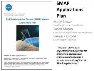
SMAP Applications Plan. Molly Brown SMAP Applications Coordinator Susan Moran Chair, SMAP Applications Working Group Vanessa Escobar SMAP Support Scientist.

E N D
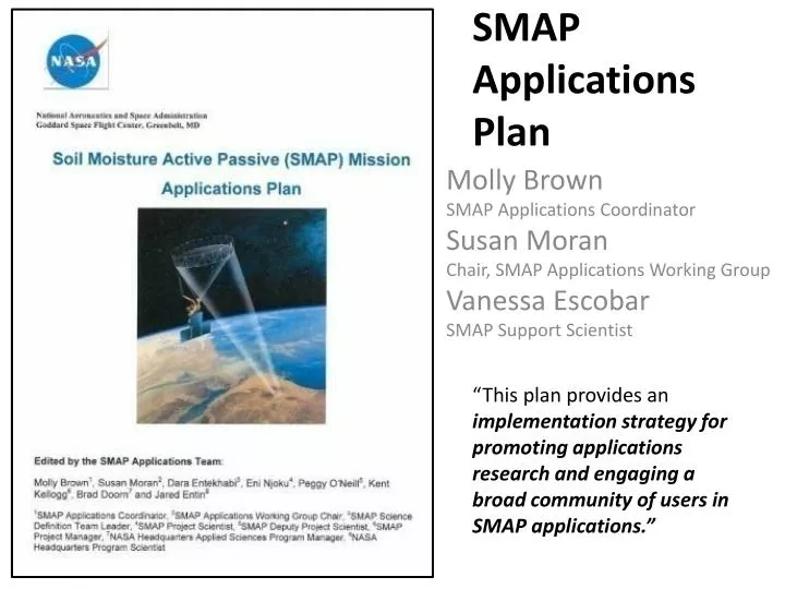
SMAP Applications Plan Molly Brown SMAP Applications Coordinator Susan Moran Chair, SMAP Applications Working Group Vanessa Escobar SMAP Support Scientist “This plan provides an implementation strategy for promoting applications research and engaging a broad community of users in SMAP applications.”
Why does the SMAP Mission have an Applications Plan? NASA Authorization Act of 2005 (P.L. 109-155) SEC. 313. PILOT PROJECTS TO ENCOURAGE PUBLIC SECTOR APPLICATIONS “The Administrator shall establish a program of grants for competitively awarded pilot projects to explore the integrated use of sources of remote sensing and other geospatial information to address State, local, regional, and tribal agency needs. Sec. 314(a): The Administrator shall establish an advisory committee, consisting of individuals with appropriate expertise in State, local, regional, and tribal agencies, the university research community, and the remote sensing and other geospatial information industries, to monitor the program established under section 313.” • National Research Council Decadal Survey Report • EARTH SCIENCE AND APPLICATIONS FROM SPACE “A fundamental challenge for the coming decade is to ensure that established societal needs help to guide scientific priorities more effectively and that emerging scientific knowledge is actively applied to obtain societal benefits. New observations and analyses, … broadened community participation and improved means for dissemination and use of information are all required.” • NASA Earth Sciences Division • APPLIED SCIENCES PROGRAM STRATEGIC PLAN Goal to “evaluate the potential for current and planned NASA missions to meet societal needs through applied sciences participation in mission science teams” and provide Mission applications support to “integrate applications needs into mission planning.”
What is a SMAP Application? Applications are defined as innovative uses of SMAP data products in decision-making activities for societal benefit. Applications research will provide fundamental knowledge of how SMAP data products can be scaled and integrated into users’ policy, business and management activities to improve decision-making efforts. Users include individuals or groups in the public or private sectors with national or international applications at local to global scales. e.g.,USAID makes decisions based on crop models that rely on high quality precipitation information in countries with poor local ground observations.
Examples of SMAP Applications Research This figure illustrates an objective evaluation of improved surface fluxes on numerical weather predictions by operational implementation of a new land surface scheme with improved soil moisture initial conditions (Bélair et al., 2003). Results in this figure indicate the relative improvement in root-zone soil moisture retrievals when surface soil moisture information was included in soil water balance models (Bolten et al., 2009).
The SMAP applications program will be considered a success if we can describe, document and verify the benefits of SMAP data in at least: • 2 applications at the TRL-A Level 7-9 • 2 applications at the TRL-A Level 4-6 • 2 applications at the TRL-A Level 1-3 • In addition, funds permitting, we will conduct one comprehensive study enabling quantification and monetization of the benefits of at least one application by the end of the first two years after launch.
Applications Plan Implementation Strategy • Two engagement levels: • Community of Practice • Community of Potential • Implementation Strategy • 1) Engagement with Early Adopters • 2) Promotion of Community of Potential • 3) SMAP Applications Research, possibly • funded by ROSES call • 4) Coordination with SMAP Cal/Val • 5) Coordination with other DS Missions
1) Engagement with Early Adopters • What is an Early Adopter? • Early Adopters are defined as those groups or individuals who have a clearly defined need for SMAP-like soil moisture or freeze/thaw data and who have sufficient interest and personnel to demonstrate the utility of SMAP data for their particular application. • Recall that applications are defined as innovative uses of SMAP data products in decision-making activities for societal benefit. Why are we engaging Early Adopters? To conduct pre-launch applications research to accelerate the use of SMAP products after the launch of SMAP • How are we engaging Early Adopters? • MOA (unfunded, immediate) • ROSES RFP (funded in late 2012)
Memorandum of Agreement with Early Adopters (unfunded, immediate) • SMAP commitment • Provide simulated SMAP data products • Provide access to cal/val data • Early Adopter commitment • Conduct applications research • Join the SMAP Applications Team • Attend SMAP Applications Workshops to report results ROSES RFP (under construction) • $150K 18-month studies to be completed before the launch of SMAP • Timeline • Work out RFP details over next 12 months • RFP announced Jan 2012 • Projects funded October 2012 • SMAP launch November 2014
4) Coordination with SMAP Cal/Val • The 2nd SMAPCal/ValWorkshop is planned for May 3-5, 2011 Oxnard, CA USA • The next Cal/Val Experiment: SMAPEx-3: September, 2011, Melbourne, Australia • SMAPExwill utilize airborne radar and radiometer data replicating the SMAP configuration in terms of frequency, viewing angle and resolution ratio, as well as supporting ground data on soil moisture, vegetation properties, soil temperature and surface roughness. CanEX (wet) – June 2010 SMAPEx-1 (winter) – July 2010 SJV (orchards) – Summer 2010
Soil Moisture Cal/Val • High Priority Candidates – Compatible with validation requirements, parallel programs, partnerships with formal commitments, strength of supporting program – Canada, Australia, SMOS Core Sites (Valencia, Danube), Mongolia (GCOM-W) • Next Priority Candidates – Data sparse regions, would require more significant efforts to use in validation, some level of common interest – Africa, Argentina, Brazil, Asia Water Cycle • Low Priority Candidates – High latency, sparse, unverified, no infrastructure support
Freeze/Thaw Cal/Val Yellow: Alectra Pink: USDA-SCAN Green: NRCS-Snotel Red: Fluxnet White: WHO
1st SMAP Applications Workshop, NOAA, September 9-11 2009 2nd Annual SMAP Applications Workshop, USDA, October 12-14 2011
Additional Applications Identified at the 1st SMAP Applications Workshop (Sept 2009 at NOAA SMC)
Upcoming Workshop Goals • Report progress from 1st Applications Workshop • Engage AppWG members in SMAP Cal/Val plans • Connect with the Community of Potential • Encourage more international participation in AppWG • Share lessons learned from applications research by SMAP Early Adopters • Thus, encourage more Early Adopters • Facilitate feedback from AppWG to SMAP Mission
Interested in joining the SMAP Applications Working Group? • Sign up at http://smap.jpl.nasa.gov/science/applicWG • Email molly.brown@nasa.gov susan.moran@ars.usda.gov • Call Molly Brown (301) 614-6616 • Susan Moran (520) 670-6380 X171