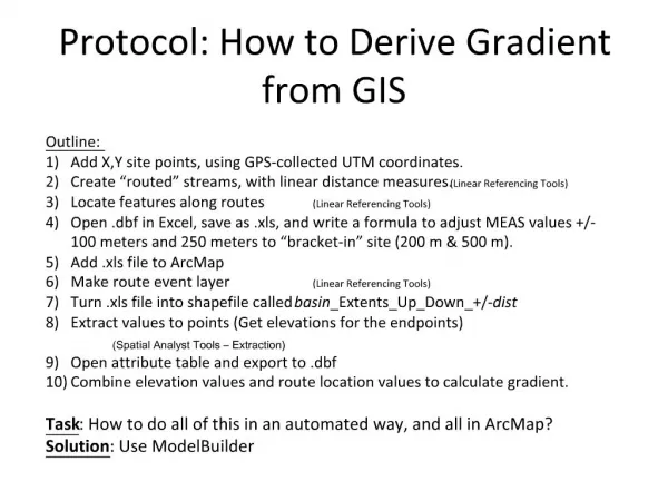
Download
1 / 5
50 likes | 133 Views
Routemap to derive ISO models from BUFR. Why do we need both ISO and BUFR models? The BUFR data model is very large – much larger in principle than most (any?) ISO 191xx data models ISO models are intended to foster open data exchange between different communities using open software

E N D
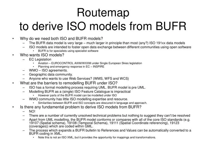
Routemap to derive ISO models from BUFR • Why do we need both ISO and BUFR models? • The BUFR data model is very large – much larger in principle than most (any?) ISO 191xx data models • ISO models are intended to foster open data exchange between different communities using open software • BUFR is for specialists using specialist software • Who wants ISO models? • EC Legislation • Aviation – EUROCONTROL AIXM/WXXM under Single European Skies legislation • Planning and emergency response in EC – INSPIRE • WMO – ISO agreements. • Geographic data community. • Anyone who wants to use Web Services? (WMS, WFS and WCS) • What are the barriers to remodelling BUFR under ISO? • ISO has a formal modelling process requiring UML. BUFR model is pre UML. • Modelling BUFR as a (single) ISO Feature Catalogue is impractical • However parts of the BUFR model can be modelled under ISO • WMO community has little ISO modelling expertise and resource. • Similarities between BUFR and ISO concepts are obscured in language and approach. • Is there any fundamental problem to derive ISO models from BUFR? • NO! • There are a number of currently unsolved technical problems but nothing to suggest they can’t be resolved • Apart from UML modelling, the BUFR model conforms or compares with all of the core ISO standards (e.g. 19107 (Spatial schema), 19108 (Temporal Schema), 19111 (Spatial Coordinate referencing), 19123 (coverages)) which are coded within GML. • The process which expands a BUFR bulletin to References and Values can be automatically converted to a BUFR coding in XML. • Note this is not an ISO XML, but it provides the opportunity for mappings and transformations.
BUFR vs ISO • What are the advantages of BUFR? • BUFR is a WMO standard • BUFR already exists and is the intended main data exchange format in WMO. • BUFR bulletins (feature instances in ISO terms) are highly compact. • Most suitable for bulk data transfer. • The BUFR data model is comprehensive for Meteorology and extensible (e.g. Oceanography) • ET DR&C controls an active maintenance process • This is arguably the biggest advantage of BUFR. • Disadvantages of BUFR? • Perceived as complex – certainly extensive • Not integrated into Web Services – not suitable for external public data exchange • WMO community specific • What are the advantages of ISO Modelling? • As well as ISO, 191xx standards are also OGC standards such as GML and Observation and Measurement. • ISO standards are well supported by IT industry software. Different software solutions will be developed. • XML under GML (Geographic Markup Language) Application Schemas is the current data exchange format with extensive software support. • ISO has standard mechanisms for cross-community publication and registries for Web Services • Highly suitable for data exchanges after extraction and aggregation of data from different datasets • Disadvantages of ISO/ XML/GML • ISO 191xx is overwhelmingly for spatial data models, and much of the modelling is to support 2D geographic operations • Extension for 3D and multi-Dimensionality is limited in practice. • Meteorology concentrates on physical processes – spatial modelling is NOT the major task. • WMO community has some re-interpretation to do with ISO concepts. • XML/GML is bloated – not suitable for bulk data exchange • Highly suitable for smaller scale external data exchange.
Steps on the route • BUFR XML • The process expanding/decoding BUFR bulletins to matching references and values can be easily extended to a BUFR XML • May be problems with “scope” of coordinates • Component BUFR communities • No BUFR user community uses all the BUFR model • Identify these communities and their BUFR subset • E.g. Aviation (WXCM), Oceanography, Hydrology, PWS • Create ISO “Feature Catalogues” of this BUFR Subset • This is probably automatable • Feature catalogues can use “community names” for BUFR entries • E.g. Air temperature for Dry-Bulb Temperature at the surface • Names in other languages • The feature catalogue should have references to all appropriate BUFR entries • Using XPath references to the BUFR XML. • This allows powerful hierarchical specifications to be defined (e.g. it can deal with “Dry-Bulb Temperature F0X12Y001 or F0X12Y101 defined at surface or NOT defined at any other level”) • A generic GML application schema may be possible for these feature catalogues • Defining where, when, who metadata (probably using WMO Core Metadata) • (Feature catalogues are the what and feature instances are the how - the specific data).
ISO 19000 Modelling process for BUFR BUFR is too big to be represented in a single ISO Feature Catalogue, which should be small enough to be useable by external communities. No external community uses the full BUFR model, and most communities use a small subset, augmented with extractions, aggregations, and compounds of this subset. The ISO model is intended for this sort of use. Full BUFR Model Aviation Hydrology Public Weather Service Aviation Feature Catalogue Hydrological Feature Catalogue Public Weather Service Feature Catalogue Aviation Feature Catalogue Aviation community names linked to (one or more) BUFR table elements Hydrological Feature Catalogue Hydrological community names and common aliases Public Weather Service Feature Catalogue Common names, aliases and language variants linked to relevant BUFR table elements
What are the advantages • ISO models are derived from the BUFR model • The maintenance process is fundamental and is not changed • References to BUFR entries from Feature Catalogues are invertible. • Relevant changes to the BUFR model can be mapped and notified to the user communities • The structure allows an automatic mapping from BUFR to XML/GML • Not necessarily the implementation (although likely to be possible using XML tools) • The structure allows servicing of data requests which include extraction of data subsets across sets of BUFR data. • E.g. query for all air temperatures within a space and time window. • All surface BUFR bulletins expanded into BUFR XML • All mappings of air temperature to BUFR elements selected (with relevant position and times) • The data returned in an XML/GML encoding under WFS.