Download
1 / 30
310 likes | 950 Views
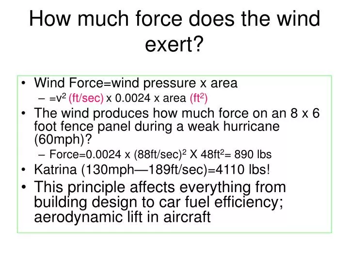
How much force does the wind exert?. Wind Force=wind pressure x area =v 2 (ft/sec) x 0.0024 x area (ft 2 ) The wind produces how much force on an 8 x 6 foot fence panel during a weak hurricane (60mph)? Force=0.0024 x (88ft/sec) 2 X 48ft 2 = 890 lbs Katrina (130mph—189ft/sec)=4110 lbs!

E N D
How much force does the wind exert? • Wind Force=wind pressure x area • =v2 (ft/sec)x 0.0024 x area (ft2) • The wind produces how much force on an 8 x 6 foot fence panel during a weak hurricane (60mph)? • Force=0.0024 x (88ft/sec)2 X 48ft2= 890 lbs • Katrina (130mph—189ft/sec)=4110 lbs! • This principle affects everything from building design to car fuel efficiency; aerodynamic lift in aircraft
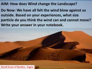
Wind and Exposed Soil Microscale winds bounce and skip sand grains, expose desert pavement, erode patterns into rocks, and shape sand dunes with ripples revealing wind direction.
Wind and Snow Surfaces . Turbulent eddies of wind can trigger rolling of moist snow to create cylindrical snow rollers. Snow fences are used to accumulate snow so that it does not drift over roads
Wind and Vegetation Wind speeds increase with elevation above earth's frictional surface, where stronger winds sculpt and denude the branches of trees. Shelter belts may protect downwind property, but may also create unwanted turbulent eddies.
Wind and Waves -Water waves are generated by surface friction and eddies that force winds and water upward and downward. -Wave height increases with wind speed, wind duration, and fetch (the length) of open water.
Wind Direction and Origin -Wind direction is typically given as the origin from which it blows, such as "westerlies" coming out of the west. -Counter-examples use the adverbs 'on' and 'up' to indicate direction, such as 'onshore wind', and "upslope wind" for wind moving uphill.
Charting Prevailing Winds -Winds shift in direction, noted by degrees or compass direction, and knowledge of prevailing wind directions are useful in planning. -A wind rose of likely directions might be used to orient runways and pollution sources .
Wind Rose • Monthly or annual average speed and directions represented graphically
Wind Measurements -Pilot balloons observed with theodolites, and rawinsondes are useful ways to detect winds in the lower atmosphere. -Doppler radar detects changes in wind speed. Also very helpful in identifying developing storms and tornadoes.
Thermal Circulations -Solar heating and radiational cooling of earth's surface generates cold-core thermal highs and warm-core thermal lows. -Winds can circulate between these two systems.
Thermal Winds Changes in air temperature causing warm air to rise and cool air to sink can also generate horizontal winds. Rising warm air creates a surface low and upper level high. Sinking cool air creates a surface high and upper level low.
Land/Sea Breeze • Forms when large scale pressure differences are small (large scale winds are weak), or when large scale winds are blowing in direction of breeze development. • There must be strong temperature differences between land and water. • Leading edge of the sea breeze front frequently will cause lifting and trigger thunderstorms.
Sea/Land Breezes • Land heats more quickly than water, creating land-water temperature differences along a coastline. • - During the day the land's warm-core thermal low draws a sea breeze, while at night, the warmer sea draws a land breeze.
Sea and Land Breezes Opposing breezes may converge on an isthmus of land, and this rising moist unstable air will trigger thunderstorms. The leading edge of land-water breezes can bring rapid changes in humidity or pollutants.
Asian Monsoon Seasonal reversal of monsoon winds in southern Asia is explained by continental temperature shifts. Summer monsoon depressions of low pressure and rains are enhanced by solar insolation, latent heat of condensation, and jet stream patterns. El Nino-Southern Oscillation is also known to affect monsoon intensity.
Southwest US Monsoon Monsoon-like winds develop in July across the southwestern U.S. region. As the continental interior heats and rises, humid Gulf air sweeps in creating instability and thunderstorms
Mountain and Valley Winds -Solar heating of hill slopes creates air that is warmer and less dense than air at the same elevation over the valley, and generates rising valley breezes. -Nighttime radiational cooling of the mountain slope creates relatively denser air that sinks as a mountain breeze, or gravity wind.
Mountain and Valley Breezes Daily warming of mountain slopes that trigger valley breezes of moist air may result in cumulus clouds above mountain summits.
Katabatic Wind • Elevated plateaus with snow cover may foster development of a thin layer of high pressure cold air. • Pressure gradient winds are triggered due to lower pressure above the adjacent valley, pushing cold air into the lower valley…can be as strong as 100 kts • Common in Columbia River Gorge in Washington state; in the former Yugoslavia, and France
Chinook Winds • Known as the “snow eater”, or Chinook winds • Common in US Great Plains • Strong westerly winds force air upslope • Moisture condenses and precipitates when ascending high mountains • The air is then warmed upon descent • Air is much warmer and much drier on the lee side of the mountain The drying/warming process happens any time the air rises and then descends over high mountain ranges, but Chinook winds form when upper level winds are strong and perpendicular to the mountain range
Chinook Wall Cloud Chinook wall clouds are an indicator of the presence of Chinook conditions.
Santa Ana Winds Easterly winds that descend from southern California's elevated desert plateau are heated by compression and lowered in humidity.
Santa Ana Story • Named after Southern California's Santa Ana Canyon and a fixture of local legend and literature, the Santa Ana is a blustery, dry and warm (often hot) wind that blows out of the desert. • In Raymond Chandler's story Red Wind, the title being one of the offshore wind's many nicknames, the Santa Anas were introduced as "those hot dry [winds] that come down through the mountain passes and curl your hair and make your nerves jump and your skin itch. • On nights like that every party ends in a fight. Meek little wives feel the edge of the carving knife and study their husbands' necks. Anything can happen."
Haboob Winds Al Asad, Iraq -Desert winds with dust and sand may form from cold downdrafts along the leading edge of a thunderstorm. -These winds are most commonly found in the African Sudan and Arizona Sonora deserts.
Dust Devils -Not a tornado -On a hot, dry day the sun strongly heats the surface of the ground, causing strong thermals….
Dust Devils -Winds near the surface can cause the thermal to spin -The dust devil then creates a rising column of dust and (light) debris.


![[How Much Does Dental Insurance Cost]](https://cdn0.slideserve.com/339593/how-much-does-dental-insurance-cost-dt.jpg)