Download
1 / 16
160 likes | 294 Views
GOMOS Mission Planning Overview. ESTEC – SEPTEMBER 10, 2002 9:15 – 9:30. Paul Snoeij, Bertrand Théodore, Alain Hauchecorne. GOMOS Observation Geometry. Pointing range Azimuth: -10 to 90 degree w.r.t anti-flight direction Elevation: 62 to 68 degree from nadir direction

E N D
GOMOS Mission Planning Overview ESTEC – SEPTEMBER 10, 2002 9:15 – 9:30 Paul Snoeij, Bertrand Théodore, Alain Hauchecorne
GOMOS Observation Geometry Pointing range Azimuth: -10 to 90 degree w.r.t anti-flight direction Elevation: 62 to 68 degree from nadir direction Tracking range Azimuth: 7.4 degree Elevation: 6.5 degree Rallying Speed 50 degree star separation = 24 Seconds Max Tracking Duration 250 Seconds Tracking altitude -15 to ~248 Km
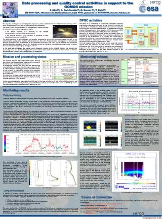
Depending on the season, there are 150 to 250 stars bright enough that they can be acquired and tracked by GOMOS. Shown is an example of one orbit with all available occultation's. But only about 40 occultation's can be measured per orbit. The objective of the mission planning is to select the stars to be used in order to fulfil the mission objectives. • The mission planning considers: • star-specific criteria • occultation specific criteria
The GOMOS Cal/Val observation plan is given by: Required monitoring modes for instrument calibration One science objective merit function with one specific product accuracy table (global stratospheric ozone monitoring) Limited altitude range Set of ground stations (defined by the ACVT-GBMCD team) Set of campaign locations (defined by the ACVT-ESABC team) Set of fixed stars based on Cal/Val plan requirements ground station / campaign locations (defined by the GOMOS ESL team) Resulting in a timeline (temporal distribution of the measurements over time) GOMOS Cal/Val Observation Plan
The observation planning to be generated is split in two main groups, according to their objectives: a) Calibration measurements. b) Verification measurements. The calibration measurement consists of a number of occultation and monitoring mode observations throughout the commissioning phase. The verification observations consist primarily of the background plan. GOMOS Observation Planning
GOMOS Calibration Needs Main parameters re-characterised during the commissioning phase: Correction functions Parameter (for in-orbit calibration) Comment / required accuracy Cosmic ray processing Threshold value Median filter Digital to electron conversion Sensitivity [LSB / radiometric unit] Monitoring of drift Non-linearity < 0.1 % Electronic chain offset < 1 % Dark Charge Removal Dark Signal < 1% Mirror reflectivity correction SFM Reflectivity Calibrated on-ground; 0.05%/deg Star background estimation Pixel-Response Non-Uniformity < 1 % IR Vignetting < 5% Slit transmission Star signal estimation Pixel-Response Non-Uniformity < 1 % IR Vignetting < 5 % Wavelength Assignment Wavelength Assignment1/3 pixel Level 2 processing Line Spread Function 5 % Only a very limited number of parameters were expected to change (red) and required recalibration
Instrument Calibration Supporting Modes Besides the normal occultation mode, GOMOS has four other operation modes useful for calibration purposes. • The Linearity mode is the same as the occultation mode except that the integration time can be programmed from 0.25 to 10 second in steps of 0.25 second. • The Uniformity mode produces pixel images of both spectrometer, photometer and SATU1 sensors. In this mode the instrument operates in open loop (no active tracking of stars, only orbit compensation). • The Spatial Spread Mode produces, as in uniformity mode, pixel images of spectrometers, photometers and SATU’s. The difference is that the mode operates in closed loop with the tracking chain and hence needs a star target to track. • The Fictive Star Modeis similar to the occultation mode except that there is no active tracking (the star is specified with a specific position and speed) SATU= Star Acquisition and Tracking Unit
The background measurement scenario is defined by the scientific objectives as recommended by the ESA earth science division (EOP-FS) with the advice of the GOMOS science advisory group. The background-plan is primarily meant to be executed after the GOMOS commissioning phase, although it has been decided within the GOMOS ESL to use some of the objectives also during the commissioning phase. These measurements satisfy in most cases the requirements of the commissioning verification activities. Additional observations for e.g. ground stations, and balloon- and aircraft campaigns are added for the purpose of the verification activity under the form of set of fixed stars. GOMOS Background Observation Plan
GOMOS Commissioning Observation Plan The mission planning considers the importance of each mission objective. For each constituent a priority value is defined for each altitude region. During the commissioning phase stratospheric ozone monitoring with global coverage is used, with the following priority for the vertical column in the 20-30 km region. The accuracy requirement involves two values, the region of best accuracy and the worst accuracy that is still acceptable. Criterion Requirement Priority O3 accuracy 2% / 5% 1
GOMOS Mission Planning FOS Flight Operation Segment PDS Processing Data Segment IECF Instrument Engineering Calibration Facility Data / Processing Configuration Observation commanding GOMOS Commissioning Centre Processor update RGT Reference Operation Plan Generation Tool Products Observation planning AO Groups External Scientific Studies NILU Norwegian Institute for Air Research SODAP Switch-On & Data Acquisition Phase Group
GOMOS Mission Planning GOMOS ESL Team GOMOS measurements from the PDS Mission planning inputs Instrument Commanding FOS @ ESOC GOMOS RGT Operator @ ACRI / ESTEC Mission planning files
Based on the Cal/Val requirements the GOMOS mission planning files are generated using the RGT Generation of a table with available stars during the planning period (at present a planning period is one week) Selection of the most appropriate stars, based on the requested mission objective and instrumental accuracy's and operational restrictions Generation of the macro command lists to be send to the FOS Visualisation of the measurements for verification After the generation the files are transferred to the FOS/ESOC. Just before up linking to the instrument a last check is performed with the latest available expected attitude of the satellite during the measurements. GOMOS Planning Generation
GOMOS Mission Planning Targets The GOMOS star catalogue consist of: 899 Hipparcos catalogue stars 100 Dark Targets (DSA) 7 Planets These targets can all be selected based on their availability during the measurements. During the commissioning phase only the 180 brightest stars and 100 DSA’s were made available for target selection. The use of planets as targets is still to be investigated.
Star Catalogue GOMOS Cal/Val plan STARSCENE Observation requirements Star opportunity table STARSEL ACVT teams Selected star table and/or Selected monitoring mode STARPOS Attitude prediction FOS flight star table file
GOMOS Global Coverage Example of the global coverage of GOMOS using the Cal/Val based selection of stars and after one day of measurements
After refinement of some pointing margins and some other minor undocumented features the GOMOS Mission Planning tools are working satisfactory The time-delay between the generation of the plan and the results from the measurements (> 10 days) caused some (instrumental) problems An assessment of the capabilities for selecting stars close to ground stations is in progress The different mission objectives and accompanying accuracy tables needs still to be improved w.r.t. to the post-launch conditions The new requirements for measuring DSA’s for improved dark charge monitoring need to be incorporated in the GOMOS mission planning Improvements with respect to a more automatic plan generation have been started Conclusions