Download
1 / 22
220 likes | 421 Views
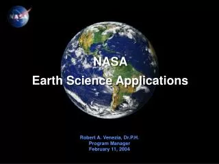
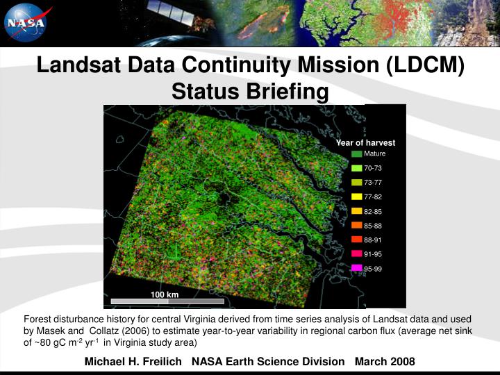
Mature. 70-73. 73-77. 77-82. 82-85. 85-88. 88-91. 91-95. Year of harvest. 95-99. 100 km. Landsat Data Continuity Mission (LDCM) Status Briefing .

E N D
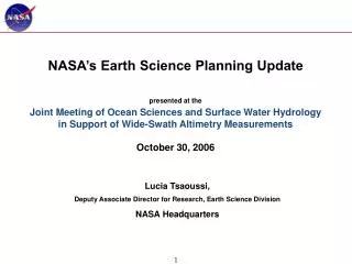
Mature 70-73 73-77 77-82 82-85 85-88 88-91 91-95 Year of harvest 95-99 100 km Landsat Data Continuity Mission (LDCM) Status Briefing Forest disturbance history for central Virginia derived from time series analysis of Landsat data and used by Masek and Collatz (2006) to estimate year-to-year variability in regional carbon flux (average net sink of ~80 gC m-2 yr-1 in Virginia study area) Michael H. Freilich NASA Earth Science Division March 2008
History of the Landsat Program Commercial Operations Gov’t Operations Gov’t Operations
Land Remote Sensing Policy Act of 1992 • The Act (P.L. 102-555) directs Landsat Program Management to study options for a successor mission to Landsat 7 that: • “…adequately serve the civilian, national security, commercial, and foreign policy interests of the United States” • “…maintain data continuity with the Landsat system” • The Act defines data continuity as: • “the continued acquisition and availability of unenhanced data which are, from the point of view of the user -- • (A) sufficiently consistent (in terms of acquisition geometry, coverage characteristics, and spectral characteristics) with previous Landsat data to allow comparisons for global and regional change detection and characterization…” • The Act states a preference for private sector funding and management of a successor mission • NASA named the successor mission the Landsat Data Continuity Mission (LDCM)
LDCM Mission Objectives • The LDCM, consistent with U.S. law and government policy, will continue the acquisition, archival, and distribution of multi-spectral imagery affording global, synoptic, and repetitive coverage of the Earth's land surfaces at a scale where natural and human-induced changes can be detected, differentiated, characterized, and monitored over time • Major mission objectives: • Collect and archive medium resolution (~30 m spatial resolution) multi-spectral image data affording seasonal coverage of the global land mass for a period of no less than five years. • Ensure that LDCM data are sufficiently consistent with data from the earlier Landsat missions, in terms of acquisition geometry, calibration, coverage characteristics, spectral characteristics, output product quality, and data availability to permit studies of land cover and land use change over multi-decadal periods. • Distribute LDCM data products to the general public on a nondiscriminatory basis and at a price no greater than the incremental cost of fulfilling a user request.
LDCM Mission Overview Mission Science Objective: Extend the multi-decadal Landsat land surface observations to study, predict, and understand the consequences of land surface dynamics Key Science Products: Moderate resolution maps of land cover/land use change over multiple decades including deforestation, agricultural extensification, and urbanization; documentation of ecosystem fragmentation and connectivity; identification and quantification of regional to continental scale sources and sinks of carbon • Mission Description: • S/C: Rapid Spacecraft Development Catalog Procurement • Instrument: Operational Land Imager (OLI) multi-spectral, 30m, • 185km swath (Ball Aerospace) • Launch Vehicle: Atlas V Model 401 (United Launch Alliance) • Orbit: 705 Km circular, sun-synch, 98.2°, 10:00 am +/- 15 mins., • 16-day repeat • Mission Life: 5 Years • Mission Project Management: NASA/USGS • Launch Date: No Earlier Than (NET) July 2011
LDCM Spectral Band and GSD Specifications Seven of the nine LDCM spectral bands correspond to bands sensed by Landsat-7’s ETM+. Two new bands are the blue band (#1) principally for coastal zone observations and a SWIR band (#9) for cirrus cloud detection
LDCM Schedule Criticality • LDCM is schedule driven to minimize the data gap with Landsat-5/7 • Landsat 5 and Landsat 7 remain in operation • Landsat 5 is 20(!) years beyond its design life (launched 1 Mar 1984) • Performance limited by subsystem degradation over time • Landsat 7 is 4 years beyond its design life • Data degraded by the failure of the Scan Line Corrector • Further subsystem failures or expected satellite fuel depletion before the LDCM launch will result in a Landsat data gap • Landsat 5 & 7 fuel expected to be sufficient for operations through 2010 • The LDCM instrument, the Operational Land Imager (OLI) development is the critical path for a July 2011 launch • The threat of a data gap is driving an aggressive OLI development schedule • 39 months vs. 60 months typical
LDCM Development Status • NASA Goddard Space Flight Center serves as mission system integrator • Acquisitions include separate procurements for: Operational Land Imager (OLI) Instrument • Contract awarded to Ball Aerospace in July 2007 • Preliminary Design Review Held March 4-7, 2008 Spacecraft • Utilizing NASA Rapid Spacecraft Development Office Catalog • Contract award in March-April 2008 timeframe • “Scarred” for potential directed manifest of Thermal and Solar Instruments Launch Vehicle • Atlas-V contract awarded to United Launch Alliance in October 2007 Mission Operations Element (MOE) • NASA will acquire the MOE for the USGS • RFP released February 29, 2008; Award in 2nd QTR CY2008
Programmatic Evolution – Thermal on LDCM • The thermal infrared capability was removed from the LDCM requirements baseline in 2002 when, under the commercial data buy, the thermal capability was determined not to be commercially viable • Following the non-award of the commercial data buy, the LDCM instrument was manifested on NPOESS • Due to technical constraints, the thermal capability was found to be unachievable • Under the current free-flyer approach, analysis of alternatives has shown that the budget profile cannot support the development of this capability • At present the development time for a thermal imaging instrument would delay the mission launch and increase the potential Landsat data gap
Programmatic Evolution – Thermal on LDCM –cont- Following the OSTP direction to develop a free-flyer, NASA provided support to affect a funding decision on a thermal capability for LDCM • Initiated thermal development analyses early 2006 with GSFC and JPL • Provided informational briefings to OSTP and OMB throughout 2006 • Thermal remained unfunded in FY07 budget • Community and stakeholder involvement increased 2006/07 • NASA supported community informational briefings to OSTP and OMB • NASA initiated studies to provide detailed cost and schedule and provided information to policy makers • Thermal remained unfunded in FY08 budget • May 2007, policy makers were made aware of the required decision date of Oct 2007 for funding/authority to proceed • Thermal remained unfunded at critical decision milestone • Stakeholder interest remains as evidenced in FY08 Appropriations language: " NASA is directed to provide a plan on all continuity of data for the Landsat Data Continuity Mission not later than 120 days after the enactment of this act ..."
Programmatic Evolution – Thermal on LDCM –cont- NASA recognized potential for late direction to develop a thermal capability and has taken steps to mitigate the schedule and cost risk • Investigated potential of International partnerships with Japan and Germany • Initiated systems engineering and management studies to define requirements and analyze interfaces • Included potential of additional instruments in early 2007 spacecraft studies • Included the capability for the provision of additional instruments within the spacecraft procurement (soon to be awarded) • NASA consulted the user community represented by the Landsat Science Team for acceptability of schedule risk due to late manifest • In January 2008, the Landsat Science Team concluded that the LDCM must be operational by Mar 2012 to observe the Northern hemisphere growing season
Programmatic Evolution – Thermal on LDCM –cont- Schedule impact of a late directed manifest for a thermal capability conflicts with user requirements for LDCM to be operational by March 2012 • Development of a thermal capability on LDCM will take ~48 months • If directed to begin today, LDCM launch date would slip 15 months to December 2012 (instrument development and s/c I&T) • Both independent and internal NASA analyses of the most expedient alternatives verifies approximate schedule impact Currently, thermal capability development for LDCM is unfunded • Earlier cost estimates are invalid: they do not account for program slip • Additional funding required to slip instrument, spacecraft, launch vehicle, mission operations development and support personnel
Overview LDCM development is on-track to support the OSTP mandate to minimize the Landsat data gap with a NET Jul 2011 launch date • OLI Instrument development through Preliminary Design • Atlas-V Launch Vehicle under contract • Spacecraft soon to be under contract • Mission Operations Element in procurement Thermal capability development for LDCM is unfunded and if directed, will impact launch date and increase the cost of all mission elements
History of the Landsat Program Landsat-1 (originally called ERTS) Landsat-2 Landsat-3 Landsat-4 Instruments: Landsat-5 MSS (79 m, 4 band) Landsat-6 (launch failure) TM (30/120 m, 7 band) ETM+ (15/30/60 m, 8 band) Landsat-7 2005 1970 1975 1980 1985 1990 1995 2000 Gov’t Operations Commercial Operations Gov’t Ops
Landsat 7 ETM+ and LDCM OLI Spectral Bands • Explanation of Differences • Cirrus Band added in 2001 to detect cirrus contamination in other channels • Coastal Band added in 2001 at request of ocean color investigators requiring higher resolution of coastal waters relative to MODIS and SEAWifs • LWIR removed from LDCM in 2002 during data buy attempt primarily due to lack of commercial market for thermal data • Bandwidth refinements made in all bands to avoid atmospheric absorption features • Enabled by higher SNR which is, in turn, enabled by push-broom instrument architecture
History of Landsat Thermal Data • Landsat satellites have acquired thermal images since 1978 • Landsat 3 (1978 -1983 ) - 240 m spatial resolution • Limited use due to calibration challenges and coarse resolution • Landsat 4 (1982 - 1989) and Landsat 5 (1984 - present) - 120 m spatial resolution • Applications increased • Landsat 7 (1999 - present) - 60 m spatial resolution • Data used for automated cloud cover assessment • Operational evapotranspiration models developed for water resouce management • Single channel thermal images collected by the same sensors collecting the multispectral data with the same swath width (185 km) • MSS - Landsat 3 • TM - Landsat 4 & 5 • ETM+ - Landsat 7
LDCM RFP Synopses • NASA released synopsis for the LDCM acquisition strategy on Oct. 24, 2006 • “NASA plans to issue an openly competed Request for Proposal (RFP) for the instrument element before the end of CY 2006 that will result in a cost reimbursable contract award in CY 2007” • “NASA continues to assess alternatives for the inclusion of a thermal spectrum sensing capability” • “NASA plans to use the Rapid Spacecraft Development Office (RSDO) contract to acquire the LDCM spacecraft element”
Landsat thermal data are now used routinely to monitor water consumption on a field-by-field basis in the U.S. West and internationally Development of energy-balanced-based evapotranspiration models SEBAL METRIC Research to Routine Use Using 120 m Landsat 5 Thermal Data Courtesy of Richard Allen, Kimberly Research and Extension Center, University of Idaho • Water rights regulation and administration are critically tied to identification and quantification of water consumption on a field-by-field basis - Allen, R.G. “The Need to Continue High Resolution Thermal Imagery …” • Typical irrigated field sizes in the U.S. range from 180 m to 750 m on a side • Quantification of water use from Landsat using thermal data is the only way to independently and consistently measure water use on a field-by-field basis - Morse, A., and R.G. Allen. “Water and the Critical Need for a Thermal Band on Landsat”
Multi-scale Ecosystem Health Monitoring FLORIDA EVERGLADES GOES (5km) MODIS (1km) L7 (60m) (hourly) (daily) (monthly) Evaporative stress (high) (low) From M.C. Anderson, PI. Multi-scale remote assessment of land-surface hydrological response to natural and anthropogenic stressors - A case study in the Florida Everglades - proposal funded from NRA-03-OES-02 - Earth System Science Research …
Science Requirements for High Resolution Thermal Data • Scaling • Surface temperature maps are required at the scale of flux tower footprints: • to scale up flux tower network measurements • to validate regional energy balance models • to tie field observations of flux to landscape scale processes • Surface temperature maps are required at the landscape scale: • to resolve small features in the landscape that consume disproportionately large amounts of water; e.g., narrow riparian corridors or irrigated fields • to assess the impact of these small features on regional scale land surface models (LSMs) - LSM validation • to assess stress within and between ecosystems • to evaluate coarse-resolution microwave estimates of soil moisture • Cloud cover screening • Cloud cover screening is required for efficient long-term or broad-scale land cover mapping at the Landsat resolution • Thermal data are needed to screen clouds in Landsat images
1986 100 km 1997 Amazonian Carbon Fluxes Net Carbon Flux (Tg C yr-1) 300 200 100 0 1975 2000 Landsat Data Continuity Mission (LDCM) Status Briefing Landsat images of tropical deforestation in Amazonia, South America Courtesy TRFIC–MSU, Houghton et al, 2000 March 2008