Download
1 / 2
30 likes | 35 Views
Compare GeoMedia vs ArcGIS Online in Geographic Information System (GIS) to analyze features, use cases, reviews and more.

E N D
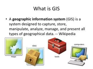
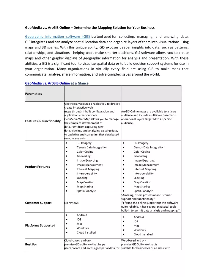
GeoMedia vs. ArcGIS Online – Determine the Mapping Solution for Your Business Geographic information software (GIS) is a tool used for collecting, managing, and analyzing data. GIS integrates and can analyze spatial location data and organize layers of them into visualizations using maps and 3D scenes. With this unique ability, GIS exposes deeper insights into data, such as patterns, relationships, and situations—helping users make smarter decisions. GIS software allows you to create maps and other graphic displays of geographic information for analysis and presentation. With these abilities, a GIS is a significant tool to visualize spatial data or to build decision support systems for use in your organization. Many organizations in virtually every field are using GIS to make maps that communicate, analyze, share information, and solve complex issues around the world. GeoMedia vs. ArcGIS Online at a Glance Parameters GeoMedia WebMap enables you to directly create interactive web maps through inbuilt configuration and application creation tools. GeoMedia WebMap allows you to manage the complete development of data, right from capturing new data, viewing, and analyzing existing data, to updating and correcting that data based on your analysis. • 3D Imagery • Census Data Integration • Color Coding • Geocoding • Image Exporting • Image Management • Internet Mapping • Interoperability • Labeling • Map Creation • Map Sharing • Spatial Analysis ArcGIS Online maps are available to a large audience and include multiscale basemaps, operational layers targeted to a specific audience. Features & Functionality • • • • • • • • • • • • 3D Imagery Census Data Integration Color Coding Geocoding Image Exporting Image Management Internet Mapping Interoperability Labeling Map Creation Map Sharing Spatial Analysis "Amazing, offers professional customer support and functionality." "I found the online support for this software quite reliable. It has several statistical tools built-in to permit data analysis and mapping." Product Features No reviews Customer Support • • • • • Android iOS Mac Windows Cloud installed • • • • • Android iOS Mac Windows Cloud installed Platforms Supported Cloud-based and on- premise GIS software that helps users collate and access geospatial data for Web-based and on- premise GIS Software that is suitable for businesses of all sizes with Best For
processing, analysis, presentation and sharing with a unified map view workflow automation, workforce routing, data management, geocoding, spatial mapping, collaboration, and remote sensing. • Subscription • One-time Purchase • Request a quote With separate products for online and desktop, an enterprise solution, and ArcGIS for Developers, the ArcGIS product suite is quite expansive. Each ESRI product is sold distinctly from the base product. Most users start with the base product and then add functionalities as required. For users who need an advanced solution with robust geospatial features, ArcGIS Online is one of the most complete mapping and data analysis software in the market. • • One-time Purchase Request a quote Pricing options Data management is GeoMedia’s unique offering - advanced data management and visualization functionality. It can also connect directly to major enterprise data servers, aggregating, and analyzing all GIS data in harmony. One more special feature is data validation tools. Data validation is significant because it verifies all incoming data for accuracy before integrating it. This saves users a step and adds important value to the product. Summary About 360quadrants 360Quadrants is the largest marketplace looking to disrupt USD 6.3 trillion of technology spend and is the only rating platform for vendors in the technology space. The platform provides users access to unbiased information that helps them make qualified business decisions. The platform facilitates deeper insights using direct engagement with 650+ industry experts and analysts and allows buyers to discuss their requirements with 7,500 vendors. Companies are able to win ideal new customers, customize their quadrants, decide key parameters, and position themselves strategically in niche spaces, to be consumed by giants and startups alike. Experts are able to grow their brand and increase their thought leadership. The platform targets the building of a social network that links industry experts with companies worldwide. The platform has around 400 buyers across various markets. 360Quadrants will also be launching quadrants in fields such as Digital Transformation Software, Cloud Computing Software, and Access Control Software. Contact: Mr. Agney Sugla agney@marketsandmarkets.com 630 Dundee Road, Suite 430 Northbrook, IL 60062 USA: +1-888-600-6441