Download
1 / 18
180 likes | 190 Views
This study examines the potential for determining cloud-tracked winds and their height assignment using optical flow/stereo techniques applied to a tandem imaging system of AATSR and ATSR-2. The Farneback optical flow algorithm is used to determine wind speeds, and the Census stereo matching algorithm is used to define wind heights. The study includes an inter-comparison with NASA MERRA wind products and a limited validation against rawinsonde data from the NOAA/ESRL Radiosonde Database network. The future potential for application to MISR-lite is also explored.

E N D
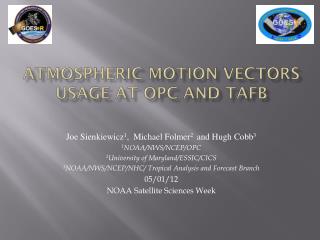
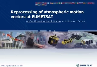
Atmospheric Motion Vectors from the tandem operation of AATSR and ATSR-2 Jan-Peter Muller, Daniel Fisher Mullard Space Science Laboratory International Winds Workshop #12, Copenhagen, 16-20 June 2014
Overview • We assess the potential for determination of cloud tracked winds and their height assignment through optical flow/stereo techniques applied to a tandem imaging system • ATSR-2/AATSR tandem operation data is exploited for this demonstration • The Farneback optical flow algorithm is used to determine meridional and zonal wind speeds. • The Census stereo matching algorithm is used to define wind heights. • An inter-comparison is made against the NASA MERRA wind products. • A limited preliminary validation is made against rawinsonde data from the NOAA/ESRL Radiosonde Database network. • The future potential for application to MISR-lite is examined. Height Wind
Dual View: Along-track Scanning Radiometer (ATSR) • Height attributes • derived from purely geometric approach • completely automated, globally • independent of radiometric calibration, temperature profiles, cloud emissivity • instantaneous height accuracies of ≈1 km, validated against ground-based radar/lidar Apparent cloud position Parallax Winds from ATSR2-AATSR tandem (30 minutes apart) for 2002/3
Example of (A)ATSR(2) Multispectral Stereo to sample thin high Cirrus over dense Strato-Cumulus False Colour Compositeof 11µm, 1.6µm, 0.68µm (left) Red/Green stereo anaglyph (right) ATSR2 Stereo CTH retrievals (thin cloud observable in 11µm stereo Muller et al. (2007) IJRS 8 (9):1921-1938 1.6µm 11µm
0.67µm Latitudinal mean CFbA AATSR stereo-CTHs over ice Fisher, D. & Muller, J-P. NCEO (2013) 1.6 N.B. Large differencein Greenland CTH & CF in stereo between 0.67 and 11µm 11 AATSR 0.67µm MISR AATSR-GRAPE MOD-CER AATSR 11µm
Tandem Operation • A single ATSR instrument can determine pixel level accuracy across track winds to quantisation of 8-10 ms-1 (dependent on scan position). • A tandem ATSR operation, with the instruments observing a shared ground track have the viewing geometries of each view approximately the same. This removes the parallax effect, and any observed displacements in the scene is related to object motion. • This enables across and along track wind determination. • For the period June 2002-July 2003 ATSR2 and AATSR operated with a shared ground track enabling motion determination in both imaging axes. • 30 minute separation between the observations allow for wind speed to be determined at 0.5 ms-1 quantisation.
Cloud Tracking • ATSR-2 orbit 38977 and AATSR orbit 3105 from the 4th of October 2002 were initially selected for analysis. • Nadir 11 μm observations used in all instances. • 3 algorithms evaluated for motion tracking: • M4 stereo matching algorithm [1]. Based on normalised cross correlation and FFT disparity refinement (in this instance FFT disparity refinement not employed) • SIFT feature matcher [2]. Scale invariant feature detection algorithm. Detects features that persist through differing scales (achieved by Gaussian blurring and non-maxima suppression). Generates description from the local feature neighbourhood. Matching through minimisation of descriptor magnitude difference. • Farneback optical flow algorithm [3]. Estimates displacement fields through analysis of polynomial expansion coefficients. Available in OpenCV. • Visual assessment of the Farneback optical flow algorithm shows that it outperforms the other matching algorithm (see next slide).
Cloud Tracking Farneback M4 SIFT
Wind heights are assigned using the AATSR forward and nadir 11 micron views in combination with the census stereo matching algorithm to ~1km quantisation[4]. • Evaluation against collocated obs. (for the 0.67 μm channel) from 17 MISR orbits over Greenland demonstrate good agreement and improved performance over M4 when using AATSR data. Wind Height Assignment Height Wind
Tandem Processing Chain Height Wind
Zero Wind Analysis • Cloud free AATSR/ATSR-2 nadir 11 micron image pair over Antarctica employed. Processed with Farneback algorithm. • Pixel displacements in both axes typically << 1 pixel. • Converted to wind components: RMSD of 0.37 ms-1, bias of 0.24 ms-1 for zonal; RMSD of 0.2 ms-1, bias of -0.14 ms-1 for meridional.
Example Outputs ATSR-2/ AATSR Farneback NASA MERRA
MERRA Comparison • ATSR-2 orbit 38977 and AATSR orbit 3105 pair 11 micron nadir channels processed with Farneback algorithm. • Converted into zonal and meridional wind components. Components compared against collocated MERRA reanalysis outputs [5] as shown in previous slide. • Meridional comparison shows a RMSE of 7.7 ms-1 and a bias of -2.5 ms-1. • Zonal comparison returns a RMSE of 6.6 ms-1 and a bias of -0.5 ms-1.
Sonde Comparison • Same ATSR2-AATSR dataset as used for MERRA compared against rawinsonde data from the NOAA/ESRL Radiosonde Database [6]. • 13 stations found to be collocated with the ATSR orbit pair and used for the assessment and plotted below (red circles). Calculated statistics shown next to plot. rmseU 7.45 biasU -1.96 rmseV 4.75 biasV 1.63
MISR-Lite : Airborne prototype UK Space Agency CEOI fund airborne prototype for flight in Adelaide, SA • Uncooled ULIS microbolometer arrays (320 x 240) • Operating in TDI mode • Mounted on a gimbal in a payload pod • Bore-sighted with lidar
SENTINEL-3 SLSTR (& OLCI) – from 2015 SLSTR 750km overlap could provide stereo (1km) winds from polar Overlap and with 2 SENTINEL-3 spacecraft possible sideways overlap
The Farneback optical flow algorithm has been identified for application to the ATSR-2 AATSR tandem operation for the determination of zonal and meridional tropospheric winds. • In a zero wind analysis the Farneback algorithm is demonstrated to result in biases of less than 0.5 ms-1 • In a comparison against the MERRA re-analysis biases of less than 2.5 ms-1 are returned. • In a limited comparison against rawinsonde data biases of less than 2 ms-1 are observed. • Future possibilities include the use of sideways and along-track overlap with Sentinel-3a,b, especially with SLSTR and the MISRlite instrument as part of the EPS-Metop convoy discussed by Ad Stoffelen in a poster Summary Height Wind
References [1] Muller, J. P., Denis, M. A., Dundas, R. D., Mitchell, K. L., Naud, C., & Mannstein, H. (2007). Stereo cloud‐top heights and cloud fraction retrieval from ATSR‐2. International Journal of Remote Sensing, 28(9), 1921-1938. [2] Bay, H., Ess, A., Tuytelaars, T., & Van Gool, L. (2008). Speeded-Up Robust Features (SURF). Computer Vision and Image Understanding, 110, 346-359 [3] Farnebäck, G. (2003). Two-frame motion estimation based on polynomial expansion. In Image Analysis (pp. 363-370). Springer Berlin Heidelberg. [4] Zabih, R., & Woodfill, J. (1994). Non-parametric local transforms for computing visual correspondence. In Computer Vision—ECCV'94 (pp. 151-158). Springer Berlin Heidelberg. [5] Rienecker, M. M., Suarez, M. J., Gelaro, R., Todling, R., Bacmeister, J., Liu, E., ... & Woollen, J. (2011). MERRA: NASA's modern-era retrospective analysis for research and applications. Journal of Climate, 24(14), 3624-3648. [6] http://www.esrl.noaa.gov/raobs/ Height Wind