Download
1 / 1
10 likes | 141 Views
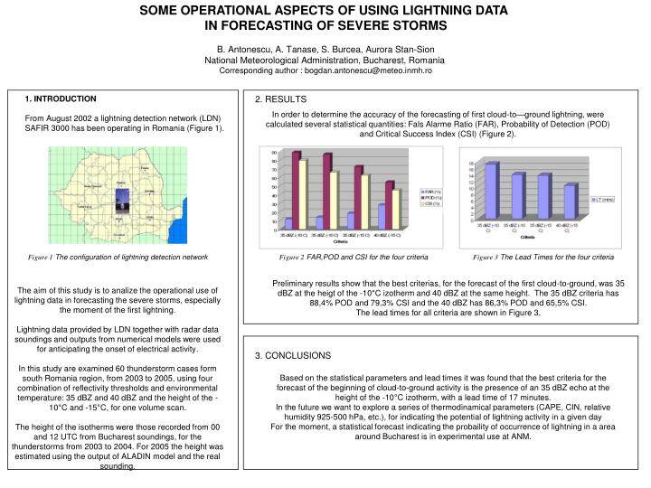
SOME OPERATIONAL ASPECTS OF USING LIGHTNING DATA IN FORECASTING OF SEVERE STORMS B. Antonescu, A. Tanase, S. Burcea, Aurora Stan-Sion National Meteorological Administration, Bucharest, Romania Corresponding author : bogdan.antonescu@meteo.inmh.ro. 2. RESULTS. 1. INTRODUCTION

E N D
SOME OPERATIONAL ASPECTS OF USING LIGHTNING DATA IN FORECASTING OF SEVERE STORMS B. Antonescu, A. Tanase, S. Burcea, Aurora Stan-Sion National Meteorological Administration, Bucharest, Romania Corresponding author : bogdan.antonescu@meteo.inmh.ro 2. RESULTS 1. INTRODUCTION From August 2002 a lightning detection network (LDN) SAFIR3000 has been operating in Romania (Figure 1). In order to determine the accuracy of the forecasting of first cloud-to—ground lightning, were calculated several statistical quantities: Fals Alarme Ratio (FAR), Probability of Detection (POD) and Critical Success Index (CSI) (Figure 2). Figure 1 The configuration of lightning detection network Figure 2 FAR,POD and CSI for the four criteria Figure 3 The Lead Times for the four criteria Preliminary results show that the best criterias, for the forecast of the first cloud-to-ground, was 35 dBZ at the heigt of the -10°C izotherm and 40 dBZ at the same height. The 35 dBZ criteria has 88,4% POD and 79,3% CSI and the 40 dBZ has 86,3% POD and 65,5% CSI. The lead times for all criteria are shown in Figure 3. The aim of this study is to analize the operational use of lightning data in forecasting the severe storms, especially the moment of the first lightning. Lightning data provided by LDN together with radar data soundings and outputs from numerical models were used for anticipating the onset of electrical activity. In this study are examined 60 thunderstorm cases form south Romania region, from 2003 to 2005, using four combination of reflectivity thresholds and environmental temperature: 35 dBZ and 40 dBZ and the height of the -10°C and -15°C, for one volume scan. The height of the isotherms were those recorded from 00 and 12 UTC from Bucharest soundings, for the thunderstorms from 2003 to 2004. For 2005 the height was estimated using the output of ALADIN model and the real sounding. 3. CONCLUSIONS Based on the statistical parameters and lead times it was found that the best criteria for the forecast of the beginning of cloud-to-ground activity is the presence of an 35 dBZ echo at the height of the -10°C izotherm, with a lead time of 17 minutes. In the future we want to explore a series of thermodinamical parameters (CAPE, CIN, relative humidity 925-500 hPa, etc.), for indicating the potential of lightning activity in a given day For the moment, a statistical forecast indicating the probaility of occurrence of lightning in a area around Bucharest is in experimental use at ANM.