Download
1 / 1
10 likes | 229 Views
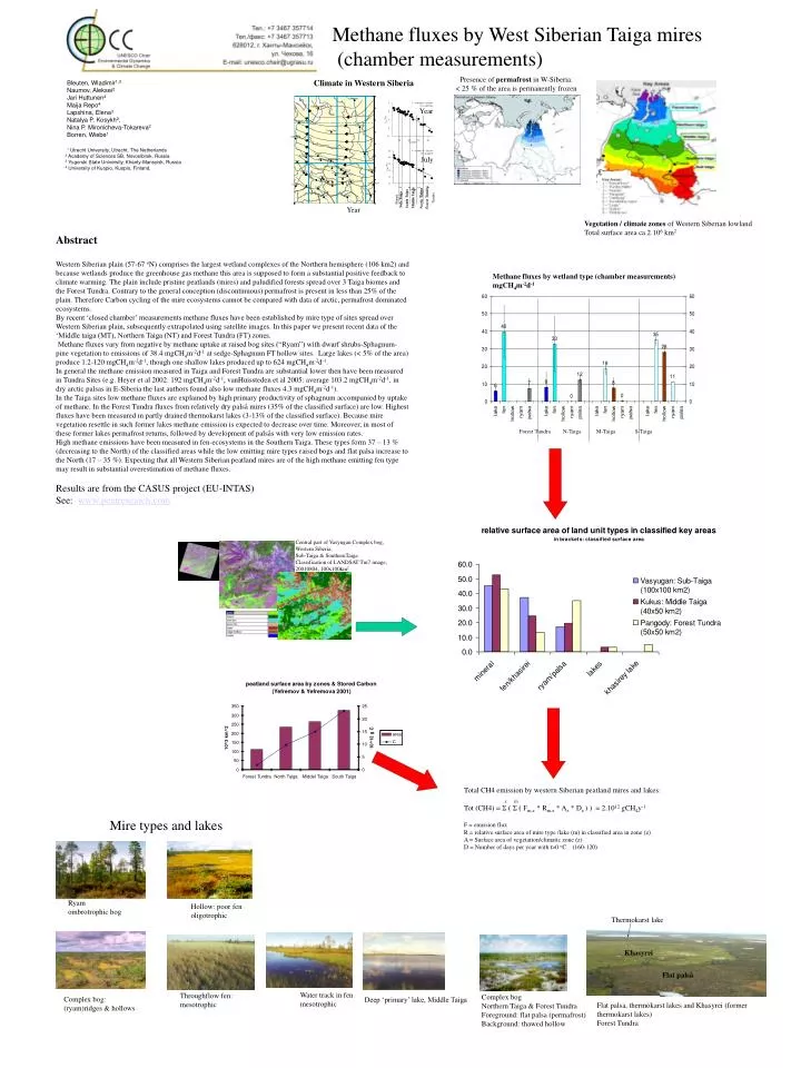
Year. Thermokarst lake. Presence of permafrost in W-Siberia: < 25 % of the area is permanently frozen. Khasyrei. July. Flat palså. Forest Tundra. Middle Taiga. North Taiga. Tundra. South Taiga. Sub-Taiga. Steppe. Year. Vegetation / climate zones of Western Siberian lowland

E N D
Year Thermokarst lake Presence of permafrost in W-Siberia:< 25 % of the area is permanently frozen Khasyrei July Flatpalså Forest Tundra Middle Taiga North Taiga Tundra SouthTaiga Sub-Taiga Steppe Year Vegetation / climate zones of Western Siberian lowland Total surface area ca 2.106 km2 Methane fluxes by wetland type (chamber measurements)mgCH4m-2d-1 Forest Tundra N-Taiga M-Taiga S-Taiga Central part of Vasyugan Complex bog, Western Siberia, Sub-Taiga & SouthernTaigaClassification of LANDSAT Tm7 image, 20010804, 100x100km2 Throughflow fen: mesotrophic Ryam ombrotrophic bog Complex bog Northern Taiga & Forest Tundra Foreground: flat palsa (permafrost) Background: thawed hollow Hollow: poor fen oligotrophic Complex bog: (ryam)ridges & hollows Deep ‘primary’ lake, Middle Taiga Water track in fen mesotrophic Flat palsa, thermokarst lakes and Khasyrei (former thermokarst lakes) Forest Tundra Methane fluxes by West Siberian Taiga mires (chamber measurements) Climate in Western Siberia Bleuten, Wladimir1,3 Naumov, Aleksei2 Jari Huttunen4 Maija Repo4 Lapshina, Elena3 Natalya P. Kosykh2, Nina P. Mironicheva-Tokareva2 Borren, Wiebe1 1 Utrecht University, Utrecht, The Netherlands 2 Academy of Sciences SB, Novosibirsk, Russia 3 Yugorski State University, Khanty-Mansyisk, Russia 4 University of Kuopio, Kuopio, Finland, Abstract Western Siberian plain (57-67 oN) comprises the largest wetland complexes of the Northern hemisphere (106 km2) and because wetlands produce the greenhouse gas methane this area is supposed to form a substantial positive feedback to climate warming. The plain include pristine peatlands (mires) and paludified forests spread over 3 Taiga biomes and the Forest Tundra. Contrary to the general conception (discontinuous) permafrost is present in less than 25% of the plain. Therefore Carbon cycling of the mire ecosystems cannot be compared with data of arctic, permafrost dominated ecosystems. By recent ‘closed chamber’ measurements methane fluxes have been established by mire type of sites spread over Western Siberian plain, subsequently extrapolated using satellite images. In this paper we present recent data of the ‘Middle taiga (MT), Northern Taiga (NT) and Forest Tundra (FT) zones. Methane fluxes vary from negative by methane uptake at raised bog sites (“Ryam”) with dwarf shrubs-Sphagnum-pine vegetation to emissions of 38.4 mgCH4m-2d-1 at sedge-Sphagnum FT hollow sites. Large lakes (< 5% of the area) produce 1.2-120 mgCH4m-2d-1, though one shallow lakes produced up to 624 mgCH4m-2d-1. In general the methane emission measured in Taiga and Forest Tundra are substantial lower then have been measured in Tundra Sites (e.g. Heyer et al 2002: 192 mgCH4m-2d-1, vanHuissteden et al 2005: average 103.2 mgCH4m-2d-1, in dry arctic palsas in E-Siberia the last authors found also low methane fluxes 4.3 mgCH4m-2d-1). In the Taiga sites low methane fluxes are explained by high primary productivity of sphagnum accompanied by uptake of methane. In the Forest Tundra fluxes from relatively dry palså mires (35% of the classified surface) are low. Highest fluxes have been measured in partly drained thermokarst lakes (3-13% of the classified surface). Because mire vegetation resettle in such former lakes methane emission is expected to decrease over time. Moreover, in most of these former lakes permafrost returns, followed by development of palsås with very low emission rates. High methane emissions have been measured in fen-ecosystems in the Southern Taiga. These types form 37 – 13 % (decreasing to the North) of the classified areas while the low emitting mire types raised bogs and flat palsa increase to the North (17 – 35 %). Expecting that all Western Siberian peatland mires are of the high methane emitting fen type may result in substantial overestimation of methane fluxes. Results are from the CASUS project (EU-INTAS) See: www.peatresearch.com Total CH4 emission by western Siberian peatland mires and lakes: z m Tot (CH4) = Σ ( Σ ( Fm,z * Rm,z * Az * Dz ) ) = 2.1012 gCH4y-1 F = emission flux R = relative surface area of mire type /lake (m) in classified area in zone (z) A = Surface area of vegetation/climatic zone (z) D = Number of days per year with t>0 oC (160-120) Mire types and lakes