Download
1 / 18
180 likes | 267 Views
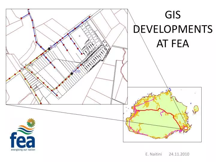
GIS DEVELOPMENTS AT FEA. E. Naitini 24.11.2010. CONTENTS. INTRODUCTION USING FEA_GIS HIGHLIGHTS FOR 2010 FUTURE PLANS CONCLUSION. INTRODUCTION. GIS reintroduced to fea in 2004 SOPAC assistance GPS and GIS training. Completed field data capture Viti Levu and Ovalau

E N D
GIS DEVELOPMENTS AT FEA E. Naitini 24.11.2010
CONTENTS • INTRODUCTION • USING FEA_GIS • HIGHLIGHTS FOR 2010 • FUTURE PLANS • CONCLUSION
INTRODUCTION • GIS reintroduced to fea in 2004 • SOPAC assistance GPS and GIS training
Completed field data capture VitiLevu and Ovalau • FEA_GIS stores Overhead Line Distribution System info, capture maintenance works records, Underground Cable system info etc.
USING FEA GISNetwork Design • Designs new extension / upgrades to existing Dist. System
Ability to combine different data sets; satellite images, topo maps, scheme plans (CAD) from Developer makes GIS important tool for Designers.
Major Projects • Proposed Nadarivatu – Nacocolevu 132kV Transmission Line. • GPS coordinates from Engineers > map onto GIS > overlay with NLTB data > identify land owning units.
Distribution Team • FEA_GIS used to plan and capture maintenance works, locating assets in the field when attending to faults, part of reports. • Now part of the requirement for planned shutdowns to include GIS map.
Distribution Team • New poles for new schemes have PoleID tags to number on site. • Data capture of new extensions to the grid
ICT • Optic fibre for communication and SCADA needs of FEA. • FEA_GIS used to determine best route to follow > calculate distance, materials, labor and cost.
HIGHLIGHTS OF 2010 • Nadarivatu optic fibre
FUTURE PLANS • Started capturing consumer meters. • Network modeling, load flow on GIS • MapInfo good for introducing GIS to FEA, currently meeting needs of users • Enterprise wide GIS.
CONCLUSION • What more can be offered? • Databases • Capturing consumer meters • On going training on how to use FEA_GIS
Acknowledgements • SOPAC • NLTB • USP • Lands Department • GIS user group
VINAKA ???