Download
1 / 1
20 likes | 193 Views
Disclaimer: This concept is based on discussions about satellite data requirements for agricultural monitoring and does not represent official USDA or ARS policy. .

E N D
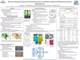
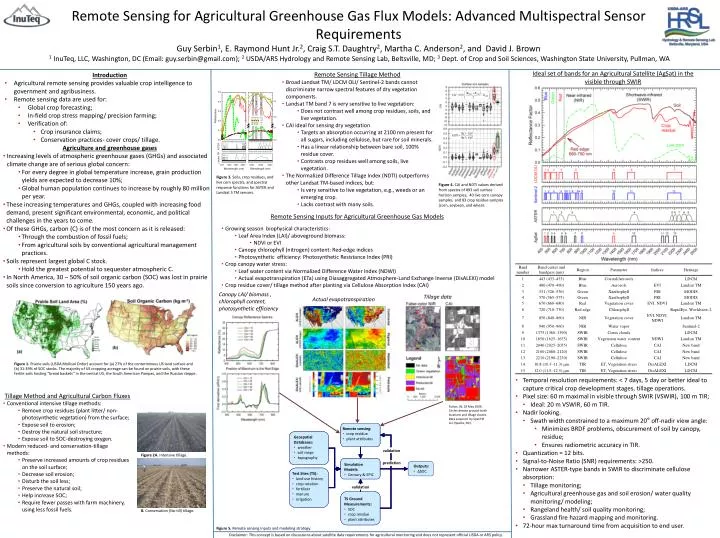
Disclaimer: This concept is based on discussions about satellite data requirements for agricultural monitoring and does not represent official USDA or ARS policy. Figure 1. Prairie soils (USDA Mollisol Order) account for (a) 27% of the conterminous US land surface and (b) 31-39% of SOC stocks. The majority of US cropping acreage can be found on prairie soils, with these fertile soils hosting “bread baskets” in the central US, the South American Pampas, and the Russian steppe. • Introduction • Agricultural remote sensing provides valuable crop intelligence to government and agribusiness. • Remote sensing data are used for: • Global crop forecasting; • In-field crop stress mapping/ precision farming; • Verification of: • Crop insurance claims; • Conservation practices- cover crops/ tillage. • Agriculture and greenhouse gases • Increasing levels of atmospheric greenhouse gases (GHGs) and associated climate change are of serious global concern: • For every degree in global temperature increase, grain production yields are expected to decrease 10%; • Global human population continues to increase by roughly 80 million per year. • These increasing temperatures and GHGs, coupled with increasing food demand, present significant environmental, economic, and political challenges in the years to come. • Of these GHGs, carbon (C) is of the most concern as it is released: • Through the combustion of fossil fuels; • From agricultural soils by conventional agricultural management practices. • Soils represent largest global C stock. • Hold the greatest potential to sequester atmospheric C. • In North America, 30 – 50% of soil organic carbon (SOC) was lost in prairie soils since conversion to agriculture 150 years ago. • Remote Sensing Tillage Method • Broad LandsatTM/ LDCM OLI/ Sentinel-2 bands cannot discriminate narrow spectral features of dry vegetation components. • Landsat TM band 7 is very sensitive to live vegetation: • Does not contrast well among crop residues, soils, and live vegetation. • CAI ideal for sensing dry vegetation • Targets an absorption occurring at 2100 nm present for all sugars, including cellulose, but rare for soil minerals. • Has a linear relationship between bare soil, 100% residue cover. • Contrasts crop residues well among soils, live vegetation. • The Normalized Difference Tillage Index (NDTI) outperforms other Landsat TM-based indices, but: • Is very sensitive to live vegetation, e.g., weeds or an emerging crop. • Lacks contrast with many soils. Ideal set of bands for an Agricultural Satellite (AgSat) in the visible through SWIR • Remote sensing: • crop residue • plant attributes AVIRIS crop residue Geospatial • Geospatial • Databases: • weather • soil maps • topography plant attributes Databases weather validation validation soil maps topography prediction Simulation prediction • Simulation • Models: • Century & EPIC Outputs • Outputs: • ΔSOC Models SOC Remote Sensing for Agricultural Greenhouse Gas Flux Models: Advanced Multispectral Sensor RequirementsGuy Serbin1, E. Raymond Hunt Jr.2, Craig S.T. Daughtry2, Martha C. Anderson2, and David J. Brown1InuTeq, LLC, Washington, DC (Email: guy.serbin@gmail.com); 2 USDA/ARS Hydrology and Remote Sensing Lab, Beltsville, MD; 3 Dept. of Crop and Soil Sciences, Washington State University, Pullman, WA Test Sites (TS) • Test Sites (TS): • land use history • crop rotation • fertilizer • manure • irrigation Century & EPIC Figure 3. Soils, crop residues, and live corn spectra, and spectral response functions for ASTER and Landsat 5 TM sensors. land use history Figure 4. CAI and NDTI values derived from spectra of 893 soil surface horizon samples, 40 live corn canopy samples, and 83 crop residue samples (corn, soybean, and wheat. crop rotation validation validation fertilizer manure Remote Sensing Inputs for Agricultural Greenhouse Gas Models TS Ground • TS Ground • Measurements: • SOC • crop residue • plant attributes irrigation Measurements • Growing season biophysical characteristics: • Leaf Area Index (LAI)/ aboveground biomass: • NDVI or EVI • Canopy chlorophyll (nitrogen) content: Red-edge indices • Photosynthetic efficiency: Photosynthetic Resistance Index (PRI) • Crop canopy water stress: • Leaf water content via Normalized Difference Water Index (NDWI) • Actual evapotranspiration (ETa) using Diasaggregated Atmosphere-Land Exchange Inverse (DisALEXI) model • Crop residue cover/ tillage method after planting via Cellulose Absorption Index (CAI) SOC crop residue plant attributes Canopy LAI/ biomass , chlorophyll content, photosynthetic efficiency Tillage data Actual evapotranspiration • Temporal resolution requirements: < 7 days, 5 day or better ideal to capture critical crop development stages, tillage operations. • Pixel size: 60 m maximal in visible through SWIR (VSWIR), 100 m TIR; • Ideal: 20 m VSWIR, 60 m TIR. • Nadir looking. • Swath width constrained to a maximum 20° off-nadir view angle: • Minimizes BRDF problems, obscurement of soil by canopy, residue; • Ensures radiometric accuracy in TIR. • Quantization = 12 bits. • Signal-to-Noise Ratio (SNR) requirements: >250. • Narrower ASTER-type bands in SWIR to discriminate cellulose absorption: • Tillage monitoring; • Agricultural greenhouse gas and soil erosion/ water quality monitoring/ modeling; • Rangeland health/ soil quality monitoring; • Grassland fire hazard mapping and monitoring. • 72-hour max turnaround time from acquisition to end user. • Tillage Method and Agricultural Carbon Fluxes • Conventional intensive tillage methods: • Remove crop residues (plant litter/ non-photosynthetic vegetation) from the surface; • Expose soil to erosion; • Destroy the natural soil structure; • Expose soil to SOC-destroying oxygen. • Modern reduced- and conservation-tillage methods: • Preserve increased amounts of crop residues on the soil surface; • Decrease soil erosion; • Disturb the soil less; • Preserve the natural soil; • Help increase SOC; • Require fewer passes with farm machinery, using less fossil fuels. • Fulton, IN, 29 May 2006. Circles denote ground-truth locations and tillage classes. Data acquired by SpecTIR LLC (Sparks, NV). Figure 2A. Intensive tillage. B. Conservation (No-till) tillage. Figure 5. Remote sensing inputs and modeling strategy.