Download
1 / 19
190 likes | 308 Views
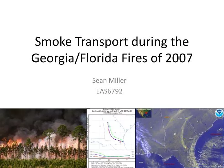
Smoke Transport during the Georgia/Florida Fires of 2007. Sean Miller EAS6792. Georgia Bay Complex Fires. Series of fires began in/around Okefenokee swamp during spring 2007 Fires merged and continued through early summer Antecedent conditions favorable for wildfire development and spread

E N D
Smoke Transport during the Georgia/Florida Fires of 2007 Sean Miller EAS6792
Georgia Bay Complex Fires • Series of fires began in/around Okefenokee swamp during spring 2007 • Fires merged and continued through early summer • Antecedent conditions favorable for wildfire development and spread • Extreme Drought • Dry soil; low RH • Strong wind from Subtropical storm Andrea
Georgia Bay Complex Fires • Burned over 2,300 km2 in SE GA/NE FL in 2007 • Smoke advected over 300 km to Atlanta metro • PM2.5 reached unhealthy levels several times
Purpose • Track mesoscale smoke transport from the fire region using active and passive remote sensing in conjunction with model back trajectories and surface observations • Use model reanalysis data to determine the mean meteorological conditions favorable for smoke transport from the fire region to Atlanta
Methods • Find Acceptable Study Days • Daily PM2.5 concentrations must violate NAAQS in the Atlanta region (mass concentrations >35.5 µg m-3) • Suitable remotely sensed and/or surface based datasets must be available to infer smoke influence on PM2.5 • Track the smoke plume • Using a combination of MODIS AOD, CALIPSO backscatter, surface PM2.5 concentrations, and HYSPLIT backward trajectories • Determine favorable conditions for transport • Using NCEP/NCAR reanalysis of meteorological fields for the chosen study days
MODIS AOD • Aerosol Optical Depth • Indicates particle abundance in atmospheric column • Obtained from MODerate resolution Imaging Spectroradiometer sensors (MODIS) • MODIS located aboard Terra and Aqua polar orbiting satellites • 2 overpasses each day • 1°x1° spatial resolution regridded data • Cloud fraction /masking remove cloud contaminated pixels
CALIPSO Backscatter • CALIOP Backscatter • Cloud-Aerosol Lidar with Orthogonal Polarization (CALIOP) • Located aboard Cloud-Aerosol Lidar and Infrared Pathfinder Satellite Observation (CALIPSO) polar orbiting satellite • Active Lidar measures vertical profile of backscattered intensity • Provides profile of vertical distribution of aerosol and clouds • Surface footprint of 70 m; vertical resolution of 30 m • Able to penetrate clouds
Finding Acceptable Days • Daily PM2.5 concentrations must violate NAAQS in the Atlanta region (>35.5 µg m-3) • Evaluate surface PM2.5 concentrations • Suitable remotely sensed and/or surface based datasets must be available • MODIS AOD retrievals cloud fraction for un-obscured conditions • CALIPSO backscatter if available • Study Days Chosen • 5/22, 5/23, 5/26, 5/27, 5/28, 5/31, 6/1
Tracking the plume • Example high PM 2.5 day in Atlanta • Dry and stable • Smoke transported NE from fire region towards Atlanta
Tracking the plume • Example low PM 2.5 day in Atlanta • Moist and unstable • Smoke transported E from fire region away from Atlanta
Tracking the plume • CALIPSO Backscatter • Elevated aerosol layer in fire region (top) • Aerosol layer in western Georgia (bottom)
Conclusion • Favorable Conditions for Smoke Transport to Atlanta during fire episode • Anomalous mid-level ridging from Southeast into Great Lakes region; upper steering pattern favors anomalous northeasterly transport over the Southeastern region • Anomalous surface ridging from the Southeast into New England; low-level flow again favors northeasterly transport over the Southeast region • These meteorological patterns match the observed movement of the smoke plume via remotely sensed and surface-based datasets and are supported by computed backwards trajectory analysis
References Alston, J., I. Sokolik, and G. Doddridge. 2011. Investigation into the Use of Satellite Data in aiding Characterization of Particulate Air Quality in the Atlanta, Georgia Metropolitan Area, Journal of Air & Waste Management Association 61:211-225, doi:10.3155/1047-3289.61.2.211 Christopher, S., P. Gupta, U. Nair, T.A. Jones, S. Kondragunta, Y-L Wu, J. Hand, and X. Zhang. Satellite Remote Sensing and Mesoscale Modeling of the 2007 Georgia/Florida Fires, IEEE J. of Selected Topics in Applied Earth Sciences and Remote Sensing, 2009. National Ambient Air Quality Standards for Particulate Matter: Final Rule 40 CFR Part 50. Fed. Regist. 2006, 71, 61444-61233. Li, Z., M.C. Cribb, F. Chang, and P. Trishchenko. Validation of MODIS-Retrieved Cloud Fractions Using Whole Sky IAGER Measurements at Three ARM Sites, Fourteenth ARM Science Team Meeting Proceedings, Albuquerque, New Mexico, March 22-26, 2004.
S2: Speciation • Speciation for South DeKalb monitoring site on 5/27/07 • Uncharacteristically high concentrations of organic and elemental carbon • Combined elemental and organic carbon makes up nearly 50% of the particle species detected • These are markers for fire
S3: Forecasting Issues • Forecast challenges associated with smoke event • Meteorology played large role in daily fluctuations • Large source for error and uncertainty in daily PM forecasts for metropolitan Atlanta and Columbus areas