Download
1 / 18
180 likes | 300 Views
GeoPDFs Utilized for ePlanning Version 2. May 9, 2007 Geospatial Conference. Agenda. GIS workflow Purpose of GeoPDFs Benefits of GeoPDFs Demonstration Questions. What is ePlanning?.

E N D
GeoPDFs Utilized for ePlanning Version 2 May 9, 2007Geospatial Conference
Agenda • GIS workflow • Purpose of GeoPDFs • Benefits of GeoPDFs • Demonstration • Questions
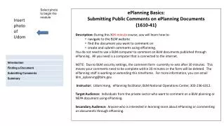
What is ePlanning? • ePlanning is content and workflow management system that assists resource specialists and line managers with land use planning and NEPA documentation. • GIS analysis, map output • LUP content creation (XML) • Publishing Engine • Comment Collection / Analysis
ePlanning LUP Specific GeoDatabase ArcGIS GeoPDF GIS Workflow Public Spatial Comments Public Review Local GIS Data Content Repository Enterprise GIS Data Records Retention
What are GeoPDFs? • Georegistered layered PDF
GeoPDF Publishing and Collaboration GeoMark for Reader Public or Reviewer Redline & Mark Up GeoPDF Review Comments Captured and Import as SDE layer
Purpose of GeoPDFs for ePlanning • Reviewer can navigate GeoPDF (pan, zoom) • Query attributes • Toggle layers on / off • GeoMeasure Tools (distance, area calculations) • Reviewer can markup (red-line) GeoPDF • Points, lines, polygons, comments, stamps • Reviewer saves comments as GeoPDF file • All markups are Georeferenced • Will be imported back to ArcSDE as georeferenced features. • Spatial comment data layers
Benefits of GeoPDF • Users familiar with Adobe Reader and PDF files • Interactive maps are difficult for Public (non-GIS users) • Better reliability and performance in external website • Free GeoPDF Toolbar for Adobe Reader/Acrobat • PDF stable, expect to be supported indefinitely • Records retention requirements much easier • Put burden on the planner to make a good stand-alone map products • Easily extends GIS to disconnected operations • Every user can be a data collector / commenter
Benefits of GeoPDF continued • Leverage BLM’s rich Geospatial data to large groups of GIS and non-GIS end users • Distribute in a standard format throughout the enterprise- business and consumer • Easy to use and implement • Control Security and Policy • Integrate and leverage existing GIS and PDF infrastructure • Enterprise Scalability
ArcGIS GeoPDF ePlanning GIS Workflow Public Spatial Comments Public Review Content Repository Records Retention
ArcGIS GeoPDF Generate GeoPDFs from ArcMap • GIS Specialist executes Map2PDF extension for ArcMap, creates GeoPDF output file • GeoPDFs ‘enabled for commenting’ by Adobe Acrobat Professional • GeoPDFs ‘enabled for Geomarking’ by GeoMark Enable
GeoPDF Send to Documentum Repository Content Repository Front Office Website • GeoPDFs sent to repository (drag and drop) • Arbortext Publishing Engine includes GeoPDF files in document build • Source GIS spatial data snapshots (zipped shapefiles) sent to repository • Metadata (zipped xml files) sent to repository • System sends source data and metadata to Front Office web site
ArcGIS GeoPDF Spatial Issue Areas Public Spatial Comments Public Review • Comments imported to SDE from GeoPDFs attached with comment submission • Provide a spatial issue area layer for all LUPs. Another way to analyze public concern. Content Repository
BLM Issues • Low number of recommended object data records in a GeoPDF (5,000) • Actual Object count depends on complexity of data • No concept of “active layer” – for selection or identify functions • TerraGo likes this idea – open to providing a solution • Multi-feature select not available • Based on Adobe’s Object Data Tools • Extraneous feature data outside of neatline • Issue for Map2PDF development team • Raster Data resolution vs file size – is image compression a possibility? • No dynamic zoom scale displayed on map – just % • Feature request for upcoming release
Demo • GeoPDF
Where to Get Information • www.terragotech.com • www.blm.gov/eplanning • On-line help and tutorials • web.blm.gov/eplanning • Back Office training • Web Trends, how to information, Information about version 2.0, etc.
Questions? Matt Brown, NG ePlanning PMNorthrop Grumman IT(720) 963-6943matt.brown@ngc.com