Download
1 / 14
140 likes | 261 Views
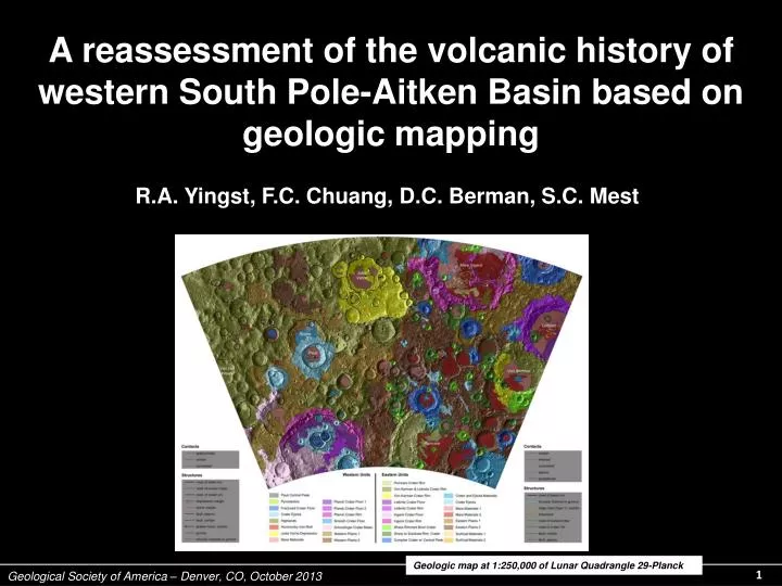
A reassessment of the volcanic history of western South Pole-Aitken Basin based on geologic mapping. R.A. Yingst, F.C. Chuang, D.C. Berman, S.C. Mest. Geologic map at 1:250,000 of Lunar Quadrangle 29-Planck. Overview. Geologic setting of the mapping site.

E N D
Geological Society of America – Denver, CO, October 2013 A reassessment of the volcanic history of western South Pole-Aitken Basin based on geologic mapping R.A. Yingst, F.C. Chuang, D.C. Berman, S.C. Mest Geologic map at 1:250,000 of Lunar Quadrangle 29-Planck
Overview • Geologic setting of the mapping site. • Methodology; criteria for identifying volcanics. • Implications • More diverse modes of emplacement • Greater area covered by volcanics Geological Society of America – Denver, CO, October 2013
LROC WAC mosaic of Planck Quadrangle Planck Quadrangle (outlined in black), with large impact structures noted. Map was created at 1:2,500,000-scale. Geological Society of America – Denver, CO, October 2013
Datasets LROC WAC mosaic of Jules Verne, Planck Quadrangle (~100 m/pxl) Clementine multispectral mosaic of Jules Verne (~100-300 m/pxl) LOLA topographic of Jules Verne (~1 m/pxl vertical) N 15 km Geological Society of America – Denver, CO, October 2013
Volcanic deposits Volcanic deposits identified by albedo, texture, morphology and spectral signature. - Mare deposits - Pyroclastics • Other volcanically derived deposits - Cryptomare candidates Geological Society of America – Denver, CO, October 2013
Mare deposits Pauli N 12 km Geological Society of America – Denver, CO, October 2013
Pyroclastic deposits N Jules Verne N 20 km Geological Society of America – Denver, CO, October 2013
Other volcanically-derived deposits Jules Verne P N 7 km N 7 km Geological Society of America – Denver, CO, October 2013
Other volcanically derived deposits Jules Verne N 5 km 5 km Geological Society of America – Denver, CO, October 2013
Cryptomare material N of Planck N 15 km Geological Society of America – Denver, CO, October 2013
Results • 22 mare deposits, 18 other volcanic deposits (7 are newly mapped). • An additional 3,000-5,000 km2 covered by other volcanics (5% more). • Broader range of volcanic expressions than previously mapped. Geological Society of America – Denver, CO, October 2013
Conclusions • Greater surface area covered by volcanics implies a greater volcanic flux. • More variations in eruptive style than previously suspected — We infer mode of emplacement of volcanic deposits (an indication of conditions at depth) was more diverse than previously thought. • Other volcanics associated with fractures — tectonic trigger? • No estimate yet on the stratigraphy of these deposits and how morphology varies as a function of time. Geological Society of America – Denver, CO, October 2013